
The central and western parts of India, which form the core monsoon zone, may face challenges in coping with the drying effects due to inadequate rainfall early in the season, Skymet Weather said.

IMD data shows in the 24 hours between September 1 and 2, Haryana received 806 per cent more rainfall than normal, Punjab 759 per cent, Himachal Pradesh 510 per cent, Delhi 740 per cent, Chandigarh a staggering 1,638 per cent, and Rajasthan 193 per cent.

Delhi is experiencing its first heatwave of the season, with temperatures reaching 40.2 degrees Celsius. Doctors have warned that exposure to extreme heat can lead to a range of health issues, from mild rashes and muscle cramps to serious conditions like heat exhaustion and heatstroke. They advise staying hydrated, avoiding outdoor activities during peak hours, and wearing light, breathable clothes. Vulnerable groups like children, the elderly, and those with pre-existing conditions are at greater risk.

'The intensity and frequency of heatwaves will be much higher than in previous years over Punjab, Haryana, Rajasthan, Gujarat, Madhya Pradesh and Odisha.'

If Jatin Singh is right in the long run and his morphed business can help reduce farmer distress, Skymet will provide a service of far more value from where it began

The minimum temperature in Delhi was recorded at 28.6 degrees Celsius, according to the India Meteorological Department (IMD).

Mumbai has seen 30 mm rain during the last 24 hours, Skymet's weather team has reported.

The Mungeshpur weather station recorded a high of 48.8 degrees Celsius, eight notches above the normal. It recorded a minimum temperature of 27.6 degrees Celsius, a notch above the season's average.

This would be the second cyclonic storm in the Arabian Sea this year.

India is likely to experience below-normal monsoon rainfall this year, with a 20 per cent chance of drought due to the end of La Nina conditions and the potential for El Nino to take hold, private forecasting agency Skymet Weather said on Monday.

The independent group of scientists and communicators previously said that winters are quickly transitioning into summer-like conditions in north India, shortening the spring season.

Cyclone 'Biparjoy', the first storm brewing in the Arabian Sea this year, has rapidly intensified into a severe cyclonic storm, with meteorologists predicting a 'mild' monsoon onset over Kerala and 'weak' progress beyond southern peninsular under its influence.

India's leading commodity exchange, National Commodity and Derivatives Exchange (NCDEX), and private weather forecasting company Skymet took a significant step towards launching the country's first tradeable weather index on Monday (August 14) by entering into an agreement to deepen their understanding of the impact that weather has on agricultural commodities. The memorandum of understanding (MoU) between NCDEX and Skymet is a profound step in the direction of linking farmers with the weather in a scientific way, according to an official statement. Sources indicate that NCDEX and Skymet will conduct workshops and seminars across the country to educate farmers about how they can scientifically use weather forecasts to hedge risks.

Pre-monsoon rainfall, colloquial referred to as "mango showers", is vital to many parts of the country.

A depression over the southeast Arabian Sea, south of Porbandar in Gujarat, is likely to move northwestward and intensify into a cyclonic storm, the India Meteorological Department said on Tuesday.

The weather department has said that the skies are expected to be partly cloudy for the next few days in Delhi.

A punishing cold wave swept Delhi on Monday morning with the minimum temperature at the Safdarjung observatory, the city's base station, plunging to 1.4 degrees Celsius, the lowest in the month since January 1, 2021.

G P Sharma, President (Meteorology) of the Skymet Weather said the Long Period Average of the rainfall during June to September will be 103 per cent with an error margin of plus or minus 5 per cent.
The four-month monsoon season from June to September accounts for 75 per cent of rainfall in the country.

Dense to very dense fog prevailed in some parts of the National Capital Region (NCR), Haryana, Punjab, west Uttar Pradesh and north Rajasthan on Tuesday.

Temperatures in March will be critical to determining the impact of any unusual heatwave conditions on this year's wheat crop in North India. It is that time of the year when the crop enters its vital grain-filling stage, say meteorologists and crop experts. So far, the high day temperatures in the North are not believed to have any significant impact on the final yields since the crop hasn't entered a stage where heat affects yields.

The country can expect normal rainfall during the southwest monsoon season as a positive Indian Ocean Dipole (IOD) and a lower snow cover over the northern hemisphere are likely to counter the evolving El Nino conditions, the India meteorological department (IMD) said on Tuesday.

Low temperature -- Delhi recorded a minimum of 13.5 degrees Celsius on Tuesday, the season's lowest so far -- allowed accumulation of pollutants, said Mahesh Palawat, vice president (meteorology and climate change), Skymet Weather.
It's still early days, but the southwest monsoon has been nearly 37 per cent 'below normal' in the first seven days (June 1-7) of this month. According to the data furnished by the India Meteorological Department (IMD), between June 1 and June 7, India received 14.5 millimetres (mm) of rainfall, against a 'normal' 23.1 mm. Among places where rains have arrived, monsoon in Kerala in the first seven days has been 48 per cent 'below normal', while in Puducherry, it has been 56 per cent 'above normal'. In Tamil Nadu, rains were 21 per cent 'above normal' between June 1 and June 7.

The city also witnessed cold wave conditions, as the minimum temperature was less than 10 degrees Celsius and five notches below normal, according to Mahesh Palawat, an expert at Skymet Weather, a private forecasting agency.

Around 29 trains have been delayed by two to five hours due to foggy weather, a railway official said.

Skymet says the IMD ignored the required criterion of two days of necessary rainfall to declare a proper onset of monsoon, reports Sanjeeb Mukherjee.
Though early days, meteorologists point towards a neutral La Nina during the initial phase of the four-month monsoon season this year that starts from June. If this holds true, by the time the rains hit the mainland, it could mean there would be one less reason to worry about the prospects of the monsoon this year. Weathermen said making any accurate prediction of how El Nino will behave and what impact it can have on the progress and distribution of rains is difficult to say at this point. A clear picture will emerge around late May or early June.

Monsoons have had limited effect on market returns for a given year, report Sachin Mampatta and Sundar Sethuraman.

Between June 1 and July 28, about 32 per cent of the 685 districts in the country did not receive adequate rainfall.

Delhi is likely to receive the first monsoon showers on June 30 or July 1, India Meteorological Department (IMD) officials said on Tuesday.

The bounteous monsoon this year has already dumped 1159.4 mm of rainfall in Delhi till Thursday afternoon, the highest since 1964 and the third-highest ever, according to the IMD data

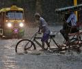
Incessant rain has lashed parts of Mumbai on Tuesday morning, disrupting local train services and road traffic with water logging in several low-lying areas. The weatherman has predicted widespread rainfall in the state during the next 36 hours.

Normally, monsoon reaches Delhi by June 27. It covers the entire country by July 8. Last year, the wind system had reached Delhi on June 25 and covered the entire country by June 29.

Monsoon normally starts withdrawing beginning September 1 from west Rajasthan.

'Cyclone Nisarga will pass by Mumbai, Thane, Kalyan, Panvel and Navi Mumbai by a safe distance,' says Air Vice Marshal G P Sharma (retd), President, Meteorology and Climate Change, Skymet Weather Services,

The Ayanagar weather station recorded 122.8 mm between 8.30 am on Wednesday and 8.30 am on Thursday, which was 11 times the normal rainfall.

Till July 26, kharif crops have been sown in around 68.87 million hectares, which is 6.43 per cent lower than the area covered during the same period last year.

On Sunday, too, a drizzle resulted in an increase in humidity, triggering a massive pollution spike.

Incessant rains continued to lash Mumbai city and neighbouring districts on Saturday, throwing normal life out of gear even as weathermen predicted heavy showers across the state for Sunday.