.jpg)
An El Nino is a temporary change in the climate of the Pacific Ocean, in the region around the equator.

Though their intensity has been less so far and the exact impact on the crop is not yet known.

Intense spells of rain are likely to continue in the districts of Thane, Raigad and Mumbai during next four hours, the India Meteorological Department (IMD) said.

'Expect very heavy rainfall at some places in Uttar Pradesh and Bihar along with sub-Himalayan West Bengal comprising of Alipurduar, Cooch Behar, Darjeeling, Kalimpong, Siliguri, Jalpaiguri, including Sikkim, parts of Arunachal Pradesh, and parts of lower Assam, Rangia downward like Barpeta, Goalpara, Dhubri along with parts of Meghalaya.'

The national capital battled weather conditions in the "red category" as the maximum temperature recorded at the Palam observatory was 46.1C,

'It could rain about 200 mm in short span of time.'

According to Skymet Weather, the initial surge in the Monsoon rains can be attributed to the transition of El Nino into the neutral phase.

IMD will present its month-wise and region-wise forecast in June.

Total area impacted across India pegged at 18.9 mn hectares.

The Centre had lowered its estimate of crop damage.

Weather watchers said it can't be known till May whether El Nio will impact the monsoon or not.

The broader market outperformed with the S&P BSE Midcap down 0.3%, while the S&P BSE Smallcap was little changed.
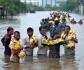
Simultaneous activation of both Arabian Sea and Bay of Bengal low-pressure systems has led to the state receiving an excess 65 per cent rainfall.

The official India Meteorological Department (IMD) and the private Skymet Weather Services have made widely divergent monsoon forecasts.

While the IMD had forecast a 'normal' monsoon for the entire season, Skymet stated that rain this year would be 'below normal', report Sanjeeb Mukherjee and Sahil Makkar.

Monsoon is expected to cover central and eastern India after Tuesday.