IMD data shows in the 24 hours between September 1 and 2, Haryana received 806 per cent more rainfall than normal, Punjab 759 per cent, Himachal Pradesh 510 per cent, Delhi 740 per cent, Chandigarh a staggering 1,638 per cent, and Rajasthan 193 per cent.

The southwest monsoon has entered its final lap, with September marking the last month of its four-month cycle over India.
Early signs suggest the season will close on a surplus, as forecast by the India Meteorological Department. But while Monsoon 2025 looks set to end with a bang, its excess has brought both bounty to farms and devastation to fields, homes and lives across large parts of the country.
Adding to that, the withdrawal pattern of the monsoon has shifted.
Traditionally beginning in the first week of September, the official withdrawal date is now September 17 -- well past the halfway mark of the month.
With the forecast of more rains, clearly, the monsoon is here to stay for a while.

A season of surpluses
IMD data shows that since the 1980s, September has more often than not recorded rainfall above its long period average of 167.9 millimetres (mm), barring only seven years: 1986, 1991, 2001, 2004, 2010, 2015 and 2019.
This year, rainfall has consistently beaten averages across the season. All-India cumulative rainfall was 8.9 per cent above normal in June, 4.8 per cent in July, and 5.2 per cent in August.
Except for patches of east and northeast India -- covering states like Bihar, Assam, Tripura, Meghalaya and Manipur -- the rest of the country has seen normal to above-normal rains.
This makes 2025 one of the most well-distributed southwest monsoon seasons.
What also stands out is not just the quantum of rainfall but also its spread and timeliness.
The distribution has been unusually uniform, with very few prolonged dry spells, something not commonly seen even in other 'normal' monsoon years.
Boost to kharif acreage
The abundant rainfall has translated into strong kharif sowing, higher reservoir levels, and healthy root-zone soil moisture that bodes well for the upcoming rabi sowing.
Government data as of August 22 shows root-zone soil moisture at levels similar to or better than the average of the past nine years across most parts of Madhya Pradesh, eastern Rajasthan, Uttar Pradesh, Chhattisgarh, Jharkhand, West Bengal, Odisha, Haryana, Punjab, Kerala, Karnataka, Maharashtra, Telangana, Andhra Pradesh, Tamil Nadu, and southern Bihar.
However, it is lower than the past nine-year average in northern Bihar, parts of Assam, Saurashtra in Gujarat, some pockets of Rajasthan, and southern Odisha.
By August 29, kharif crops were sown in over 109.28 million hectares, 3.25 million hectares more than during the same period last year, with paddy and maize leading the way.
Paddy, at 43.19 million hectares, saw an expansion of 2.66 million hectares over this period last year, while maize acreage reached 9.4 million hectares, up by nearly a million hectares.

Fertiliser shortages emerge
The rush to capitalise on favourable soil conditions has triggered a surge in fertiliser demand.
Urea sales jumped 14.2 per cent between April and July to 12.4 million tonnes compared to the same period last year, while diammonium phosphate (DAP) sales slipped 12.9 per cent to 2.56 million tonnes.
The gap was offset by higher sales of NPKS (nitrogen, phosphorus, potassium, sulphur) fertilisers, which rose 27.2 per cent to 5 million tonnes.
Usually, kharif is the season for urea and NPKS, while the rabi season is when DAP sales peak.
The imbalance led to an unprecedented shortage of urea and DAP, causing long queues at retail points as supplies lagged demand.
The Centre stepped in to place emergency orders for urea. Reports suggest this scramble has pushed global urea prices up.

Floods and crop damage
The surplus rains have also created conditions ripe for pest and disease outbreaks, impacting the kharif crop in many parts of India, raising input costs for farmers who are spending more on sprays and pesticides.
Leafhopper infestations in cotton, Fiji virus in paddy, and black grub in Gujarat are among the widespread threats reported this season.
If the early surplus rains were a boon for agriculture, the downpours since mid-August have turned destructive.
Excessive rainfall across north India -- especially in Punjab, Haryana, Himachal Pradesh, Uttarakhand, and Jammu and Kashmir -- has flattened crops and submerged fields. Parts of central India are also facing the fury of rain.
In Punjab alone, an estimated 150,000 hectares of standing crops have been submerged, potentially affecting basmati and non-basmati rice yields.
A statement by the All India Kisan Sabha said that in Haryana, farmers from 1,402 villages in 12 districts have lost their crops to the extent of almost 250,000 acres, while 25,000 acres of apple orchards in Himachal Pradesh have suffered damages.
In Jammu and Kashmir, thousands of acres of paddy have been washed away, it said.
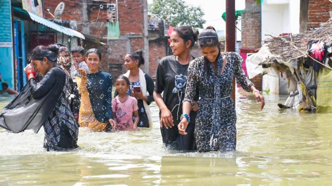
Beyond agriculture, the deluge has wreaked havoc in hilly states, sweeping away highways, bridges and homes.
Fatalities have run into the hundreds, with several states such as Himachal Pradesh and Punjab urging the Centre to declare the floods a 'national calamity'.
Cities across north India, too, have struggled with paralysed infrastructure.
IMD data shows the scale of excess was extraordinary: In the 24 hours between September 1 and 2, Haryana received 806 per cent more rainfall than normal, Punjab 759 per cent, Himachal Pradesh 510 per cent, Delhi 740 per cent, Chandigarh a staggering 1,638 per cent, and Rajasthan 193 per cent.
Union Home Minister Amit Shah has toured flood-hit Jammu and Kashmir and is holding regular reviews with affected states.
The Centre has constituted an inter-ministerial team to assess damage in Punjab, Himachal Pradesh, Uttarakhand, and Jammu and Kashmir.
Union Agriculture Minister Shivraj Singh Chouhan has set up a special monitoring cell for crop loss complaints.
Standing crop in central and west Indian states could also be impacted if rains continue throughout September.

The climate change question
While some experts have attributed the current spell of surplus rains to climate change, Madhavan Nair Rajeevan, one of India's leading monsoon specialists and former secretary in the ministry of earth sciences, doesn't think that is the case.
In an interaction with Business Standard, he said the excess rainfall over north India and the Himalayan belt in August and September is not linked to climate change but to western disturbances interacting with moisture-laden easterlies from the Bay of Bengal.
Normally, August sees one, at most two, western disturbances, but this season has had four, he said. "In winters, western disturbances drive most of the rains in the north. But such high frequency during the monsoon months is unusual."
Rajeevan said that some scientists believe the rise in western disturbances during the monsoon could be tied to the melting of Arctic Sea ice due to global warming, but emphasised that there is no conclusive evidence of that yet.
"Western disturbances usually originate from the Caspian region, travel across central Asia and reach north India. Their growing frequency during monsoon is still an unexplained phenomenon," he added.
IMD data shows that in August 2025, the country recorded 14 low-pressure system days, compared to the normal 16.3 days.
Mahesh Palawat, vice-president (meteorology and climate change) at Skymet Weather Services, a Noida-headquartered private weather forecaster, echoed Rajeevan's assessment.
The heavy rains since mid-August were mainly the result of low-pressure systems interacting with an unusually high number of western disturbances, Palawat said.
Typically, such disturbances hit north India in October and November. This year, they came in August, he said.
Southern India, too, has seen the impact of excess rains, with Chennai recently experiencing a rare cloudburst in the plains.

Fear of inflation looms
The prolonged showers, apart from causing loss of life and property, could also trigger a short-term spike in food inflation if vegetable and fruit supplies from rural belts to urban centres are disrupted.
So far, data from Agmarknet, the government's portal for market trends and commodity prices, shows that prices of key vegetables in New Delhi and neighbouring regions remain largely stable. But traders warn that transportation bottlenecks could quickly change the picture.
A study by research consultancy Climate Trends highlights how, over the past five years, extreme heatwaves and erratic rainfall have severely hit the production of tomatoes, onions and potatoes (TOP crops), fuelling food inflation.
It cites Reserve Bank of India data showing that rainfall variations push up vegetable inflation by 1.24 percentage points, while temperature shifts increase it by 1.30 percentage points.
For now, the rains are continuing to blur the line between blessing and curse. A season that promised bounty now carries the weight of loss.
Feature Presentation: Rajesh Alva/Rediff