
The recent helicopter crash near Kedarnath, in which seven lives were lost, has proven yet again that aviation regulatory authorities have not learnt lessons from similar air mishaps in the challenging Kedar valley and have done little to improve flying conditions.

India will launch its own composite index next year to quantify the impact of heat on its population and generate impact-based heat wave alerts for specific locations, the India Meteorological Department (IMD) has said.

vThe longest duration cyclone over the north Indian Ocean had developed over the Bay of Bengal and weakened over the Arabian Sea between November 8-23, 1977 with a life period of 14 days and six hours.

At least 25 people were killed in lightning strikes and hailstorms in several districts of Bihar, India, on Thursday. The India Meteorological Department has issued an 'orange alert' for a number of districts, forecasting heavy rainfall on Friday and Saturday. The state capital, Patna, recorded an average of 42.6 mm rainfall till 5.30 pm.

Skymet says the IMD ignored the required criterion of two days of necessary rainfall to declare a proper onset of monsoon, reports Sanjeeb Mukherjee.

'Nobody asked us to work on this. It was on our own that we decided to embark on this journey.'

According to the IMD, a rain event is categorised as a cloudburst if a weather station receives 100 mm of rain in one hour.

Former BCCI president Sourav Ganguly on Saturday expressed optimism about the Eden Gardens keeping its date with the 2025 IPL final

The eastern and northern parts of Delhi witnessed rain and hailstorm, IMD said.

Climate change has hampered the ability of the forecasting agencies to accurately predict severe events and weather bureaus across the world are focusing on augmenting the observational network density and the weather prediction modelling to improve predictability, India Meteorological Department (IMD) Director General Mrutyunjay Mohapatra has said.

Wholesale price inflation dropped to 0.85 per cent in April as prices of food articles, manufactured products, and fuel eased, government data showed on Wednesday. WPI-based inflation was 2.05 per cent in March. It was 1.19 per cent in April last year.

The country can expect normal rainfall during the southwest monsoon season as a positive Indian Ocean Dipole (IOD) and a lower snow cover over the northern hemisphere are likely to counter the evolving El Nino conditions, the India meteorological department (IMD) said on Tuesday.

A steady drizzle in the evening brought premature end to evening practice sessions of Kolkata Knight Riders and Royal Challengers Bengaluru on the eve of their IPL 2025 opening match on Saturday.

Scientists had earlier said the cyclone pulled the moisture and convection, impacting the intensity of the monsoon and delaying its onset over Kerala.

The national capital has been witnessing an incessant spell of light to moderate rain for the past two days.

Addressing a press conference virtually, India Meteorological Department Director General Mrutyunjay Mohapatra said September was likely to witness normal rainfall in the range of 91-109 per cent of the long period average of 167.9 mm.

Trading sentiment in the equity market will largely be driven by domestic corporate quarterly earnings, any update related to US tariffs and foreign fund movements this week, analysts said. Investors would also focus on world market trends, movement of global oil benchmark Brent crude and the rupee-dollar trend for further cues, experts noted.

Overall automobile retail sales in India grew a modest 2.95 per cent in April this year to 22,87,952 units with completion of purchases by customers around Chaitra Navratri, Akshay Tritiya, Bengali New Year, Baisakhi and Vishu helping April end on a positive note, Federation of Automotive Dealers Associations said on Monday.

'The intensity and frequency of heatwaves will be much higher than in previous years over Punjab, Haryana, Rajasthan, Gujarat, Madhya Pradesh and Odisha.'

The cold wave days in December too are expected to be 'below-normal' this year.

Heavy waterlogging was witnessed in several towns and cities, while roads were closed in rural areas on Friday morning due a heavy spell.

There could be occasional gusty winds reaching 40-50 kmph as per the weather bureau's prediction.

States are mandated to develop and implement 'heat HAPs' for prevention of heat-induced diseases. But most do not go beyond standard advisory on heat prevention.

It expects rainfall to be about 106 per cent of the long period average, aided by La Nia conditions anticipated to play a role in the second half of the monsoon season.

Climate scientists warn that climate change is intensifying heatwaves in India, with the cooling effects of La Nia potentially becoming less effective in a warmer future. The India Meteorological Department (IMD) predicts an early summer with above-normal temperatures and intense heatwave spells, following an unusually dry winter and the warmest February since 1901. Experts emphasize the role of human-caused climate change, along with natural climate drivers like El Nio and La Nia, in shaping weather patterns. While La Nia typically brings cooler temperatures, scientists suggest that under climate change, its ability to mitigate heatwaves may be diminished.

The southwest monsoon might finally start withdrawing from parts of North-West India over the next three days, signaling the end of its four-month journey over the country that started in June, the India Meteorological Department (IMD) said. However, though the retreat might begin from next week, the rains might not descend quickly, as the met department predicted fresh spells of rains in Vidarbha, Chhattisgarh and east MP on September 21-22 and over Odisha, Coastal areas north Andhra Pradesh and Gangetic West Bengal on September 19-21. "Due to anti-cyclonic flows over northwest India at lower tropospheric levels, dry weather is very likely over west Rajasthan, Punjab, Haryana, Chandigarh and Delhi during the next five days. "Hence conditions are becoming favourable for the withdrawal of Southwest Monsoon from parts of northwest India during next three days," the IMD said.

The India meteorological department on Monday issued an 'orange alert' for Mumbai and Thane signalling very heavy rainfall till June 21.

The IMD said India did not experience any "break monsoon" conditions this year because of the large number of low-pressure systems.

Residents of North India battle freezing conditions.

Incessant heavy rain lashed Mumbai, prompting the meteorological department to upgrade the 'orange' alert to 'red' with effect from Wednesday night till Thursday afternoon, officials said.

Mercury hovered around 40 degrees Celsius in large parts of the country on Monday as the Indian meteorological department predicted heat wave conditions in parts of east India over the next four days and the northwest region over the next two days.

Mumbai recorded its coldest day on Monday since December 24, 2015 with the temperature dipping to 13.7 degrees Celsius, an India Meteorological Department official said.

Skymet expects a good monsoon over western and southern India.

The rain and flood situation in northeastern states remained grim on Tuesday, with lakhs people affected in Assam, Mizoram and Manipur, even as the meteorological department predicted more rain in several parts of the region.

As Cyclone Dana barrels toward the coasts of Odisha, threatening to impact nearly half of the state's population, the government is racing against time to execute a massive evacuation plan aimed at relocating about 10 lakh people in several coastal districts to safety. In West Bengal, the cyclone is set to bring heavy rainfall in several southern West Bengal districts, including Kolkata, the India Meteorological Department (IMD) has said.

Northwest, central and east India are predicted to record maximum temperatures three to five degrees above normal over the next five days, the India meteorological department (IMD) said on Thursday.
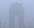
The India Meteorological Department (IMD) reported that very dense fog began forming around 5.30 am, resulting in a thick haze over different parts of the national capital.

The IMD, in its review for the month, said the observed monthly average maximum, minimum and mean temperature for the country as a whole during March this year are 32.65 degrees Celsius, 19.95 degrees Celsius and 26.30 degrees Celsius, respectively, against the normal 31.24 degrees Celsius, 18.87 degrees Celsius and 25.06 degrees Celsius based on the climatology period 1981-2010.

Cyclonic storm Fengal has commenced making landfall close to Puducherry and it may approximately take 4 hours for it to cross the coast completely, an India Meteorological Department (IMD) official said. The process of the cyclone's landfall commenced at about 5.30 pm on November 30. The IMD said the forward sector of spiral bands associated with the cyclone has entered into the land and is likely to move west-southwestwards and cross north Tamil Nadu-Puducherry coasts between Karaikal and Mahabalipuram close to Puducherry as a cyclonic storm with a wind speed of 70-80 kmph gusting to 90 kmph during next 3 to 4 hours.

The landfall process of the severe cyclonic storm Dana was complete on Friday morning and the system took at least eight and half hours to enter the landmass, India Meteorological Department (IMD) said.