
The administration is geared up for more showers as the India meteorological department has warned of heavy to very heavy rains with isolated extremely heavy rains in several districts of the state till Thursday morning.

Cold-day conditions prevailed in parts of north India on Friday though the maximum temperatures rose slightly amid clear skies and sunshine during the day.

The weather office has issued a forecast of heavy to very heavy rains at isolated places in several districts of Gujarat over the next one week.

Amid the heavy downpour in Bengaluru, residents of many flood-affected areas have taken to social media to pour out their woes ranging from waterlogging to complaining about "crumbling" infrastructure.

The India Meteorological Department (IMD) seems to have taken a cautious stand over the World Meteorological Organisation's (WMO) projection of a 'poor monsoon' due to a probable 'El Nino' impact. The IMD did not agree with WMO's projections, saying, "El Nino and the progress of monsoon are not mutually exclusive events", and remained non-committal over its earlier projection of a "normal monsoon" for the June-September 2009 season.

The IMD has issued a red-colour coded warning for the southern areas of Tamil Nadu Kerala in view of the brewing storm and said that these areas are expected to receive heavy to very heavy rainfall.

The maximum temperature on Saturday settled at 18.1 degrees Celsius, two notches below the season's average, and the minimum was recorded at 3.6 degrees Celsius, four notches below the season's average, the IMD said.

Ten to 20 days of heatwave are expected against the normal of four to eight days in the entire April-June period.

Delhi's air quality deteriorated significantly on Monday, with areas like Dwarka, Mundka and Najafgarh recording an AQI of 500, the worst this season. The city's overall AQI reached 491, triggering the implementation of the Graded Response Action Plan (GRAP) Stage-IV restrictions in Delhi-NCR. Doctors warned of health risks, urging people to wear N95 masks and avoid outdoor activities. The Supreme Court questioned the Delhi government on its anti-pollution measures and warned against scaling down preventive measures without its permission. Delhi Chief Minister Atishi accused the BJP-led central government of political maneuvering while neglecting stubble burning in states it governs. Meanwhile, the city enforced stricter pollution control measures, including a ban on truck entry and suspension of construction activities. Air purifier sales surged, reflecting the public's concern over the severe air pollution.

The IMD issued a 'red alert' for Pune district and asked people to take precautions.

As weather patterns grow more unpredictable due to climate crisis, India is taking a giant leap with "Mission Mausam" to improve weather understanding and forecasting through expanded observation networks, better modeling and advanced tools like AI and machine learning.

Satellite imagery showed a layer of dense fog extending from Punjab and north Rajasthan to the northeast. Patches of fog were also visible along the east coast.
Gross Value Added (GVA) growth in agriculture and allied activities in the first quarter of the 2024-25 financial year (Q1FY25) dipped to 2.7 per cent at constant prices from 4.2 per cent in Q1FY24 due to a drop in output of some crops following heatwave in the main growing months. Low post-monsoon rains, which dried most of the reservoirs in several states across the country, also impacted the production of many crops. At current prices, the growth was estimated at 8.5 per cent as against 4.1 per cent in Q1FY24 due to a spike in food inflation during the April to June months of FY25.

The mercury in Delhi, which recorded its hottest day of the year so far at 45.6 degrees Celsius on Sunday, came down to 42.4 degrees Celsius, according to the India meteorological department.
The heavy rains led to water level in various dams in the state rising to the red alert mark, prompting the government to open one of the shutters of Cheruthoni dam of Idukki reservoir in the afternoon.

The news will augur well for the country as large parts have been witnessing agriculture distress and water levels in reservoirs in west and south India have dipped to low levels.

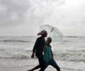
The IMD director said, the cyclonic storm Tauktae in the Arabian sea is moving away from the Kerala coast and is now approaching the Karnataka coast.

The Met office has issued a "red" warning for Delhi, Haryana, Punjab and west Rajasthan, stressing the need for "extreme care for vulnerable people".

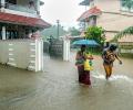
More than 39.8 lakh people in 27 of the 33 districts in the state were affected by the deluge on Thursday.

There is a definite attempt to put the landslides on the backburner because news of them and climate change worry Wayanad's tourism and real estate businesses greatly. Whatever I experienced of Wayanad's 2024 by-elections; the July landslides were not a burning issue, observes Shyam G Menon.

A total of 435 people died in the country due to extreme weather events during the last three months of the southwest monsoon, according to the data compiled by the India meteorological department.

The rains after arriving over Kerala will quickly cover Tamil Nadu and Karnataka, but then might slacken a bit, which could delay its arrival over Northwest India.

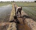
The situation in rain-battered Gujarat improved slightly on Thursday as the rainfall activity subsided, but Vadodara and some other parts of the state are still reeling under a flood-like situation due to overflowing rivers while the authorities continue the rescue and relief operations.

Heavy rains had battered the metropolis on Sunday and Monday as well.

While the IMD had forecast a 'normal' monsoon for the entire season, Skymet stated that rain this year would be 'below normal', report Sanjeeb Mukherjee and Sahil Makkar.

Heavy falls at isolated places are very likely over Kerala on April 29 and 30. The system will not make landfall in Tamil Nadu, but may bring light rain in some northern parts, it said.

Even as rains abated in most parts of Gujarat on Friday morning, several towns and villages witnessed water logging due to swollen rivers, officials said.

Meanwhile, trains ran on time on the Main and Western lines of the Central Railway (CR) and Western Railway (WR) on Saturday.

Delayed by 10 days due to cyclone Biparjoy, southwest monsoon is likely to progress further and hit Mumbai between June 23 and 25, the India meteorological department said on Wednesday.

The Mumbai civic body and police have advised all people in the city and surrounding areas to stay indoors as much as possible.
Southwest monsoon has furthered advanced into some parts of south Arabian Sea

This should augur well for the rabi crops as delayed withdrawal will leave enough moisture in the soil for early sowing.

Given IMD's past record on forecasts, the latest one could also go wrong.

The searing heat pushed the city's peak power demand to its highest for May, while the Delhi government directed the schools that have not closed for summer vacations to do so with immediate effect.
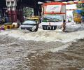
Flight services at Mumbai airport were severely impacted on Monday due to low visibility after heavy rains in the city, leading to runway operations being shut for over an hour and approximately 50 flights being cancelled, sources said.

The depression formed over Lakshadweep in the Arabian Sea would turn into a cyclonic storm in the next 24 hours and reach near the Gujarat coast on the morning of May 18, officials said.

Spurred by cyclone Remal, the southwest monsoon set in over the Kerala coast and parts of the northeast on Thursday, a day earlier than forecast by the weather office.

The threshold for a heat wave is met when the maximum temperature of a weather station reaches at least 40 degrees Celsius in the plains, 37 degrees in coastal areas, and 30 degrees in hilly regions, and the departure from normal is at least 4.5 notches.

The IMD has fancy weather-monitoring radars in the name of providing better forecasts.