
The IMD has fancy weather-monitoring radars in the name of providing better forecasts.

Retail inflation declined to a five-year low of 3.54 per cent in July mainly on account of subdued prices of food items, and base effect, according to official data released on Monday. The Consumer Price Index (CPI) based retail inflation was 5.08 per cent in June 2024 and 7.44 per cent in July 2023.
The IMD chief also allayed fears of occurrence of an El-Nino.

Among the fatalities recorded on Friday, the maximum 17 were from Uttar Pradesh, 14 from Bihar, five from Odisha and four from Jharkhand, where officials said more than 1,300 people are hospitalised with heatstroke conditions.

From the Sensex firms, Power Grid, NTPC, Tech Mahindra, Bharti Airtel, Tata Motors, IndusInd Bank, Reliance Industries, Kotak Mahindra Bank and Maruti were among the laggards. Asian Paints, Wipro, JSW Steel, Hindustan Unilever, Bajaj Finserv and Mahindra & Mahindra were among the biggest gainers.

The Odisha government has asked all the district collectors to remain prepared for any eventuality, and directed the administration to evacuate people from low-lying areas in the event of heavy rain.
El Nino is expected to occur in August-September, but it is unlikely to have any major impact on the monsoon, and the weatherman expects a positive Indian Ocean Dipole, which has a strong influence on rainfall in the country.

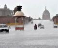
In view of the widespread rains and 'red alert' for extremely heavy showers issued by the India Meteorological Department (IMD) for several districts, control rooms are working round the clock to monitor the situation and help stranded people, he said.

The chargesheet, which was submitted in court last week, includes views of the premier VJTI, as well as IMD about the ill-fated structure being of sub standard quality and not having the capability to withstand winds, an official said.

The met department said that rainfall in August is projected to be within the normal range at 97% of LPA. In August and September, India receives around 43 mm of rainfall.

Western Railway stated that local train services were running normally on Monday morning, however, commuters claimed trains were running late by 5 to 10 minutes.

Temperatures in 17 locations breached 48 degrees Celsius on Monday, with the relentless heat affecting health and livelihoods across large parts of northwestern and central India.

With a gradual rise in temperature and the start of heatwave, FMCG and dairy firms selling cola-based fizz drinks, juices, mineral water, ice creams and milk-based beverages expect a spike in sales and have ramped up their production and stocks to meet the anticipated consumer demand. The makers are launching new products keeping in mind the evolving consumer preferences and also investing substantially on promotions and expansion of the channels this season, company executives of beverage and ice cream makers said. Beverages major PepsiCo said summer months are naturally the most favourable season for its category and it is "optimistic" that its portfolio of brands will continue to delight consumers during the period.

As per the India Meteorological Department (IMD), which closely monitors the cyclonic storm said, 'The SCS 'Mocha' intensified into a very severe cyclonic storm, lay centred at 05.30 hours IST of 12th May 2023 over central adjoining southeast Bay of Bengal near latitude 13.2N and long 88.1E, about 520 km west-northwest of Port Blair.'

Five people died in rain-related incidents in Delhi Friday as Monsoon arrived with a fury early in the morning, lashing the city with its highest rainfall in a single day of June in 88 years which brought it to a standstill with streets flooded, traffic in chaos and some commuters stranded on roads.

Sowing had started on a sluggish note in several parts of the country because of delay in the onset of the monsoon but has picked up pace subsequently as the rains progressed and performed appreciably well in August.

As severe cyclonic storm 'Remal' initiated its landfall process between the coasts of Bangladesh and adjoining West Bengal on Sunday evening, authorities took swift action, evacuating over 1 lakh people from vulnerable areas of the state to safety.

While rain intensity reduced on Tuesday compared to a day ago, affecting mainly districts in the Saurashtra region, administration carried out rescue and relief operations on a large scale, shifting thousands of people to shelters.

She added that light rains are also expected in Banaskantha and Sabarkantha districts on October 16, adding that the possibility of light rains at a few places in Ahmedabad cannot be ruled out for that day also.

After churning across the Arabian Sea for more than 10 days, Biparjoy made landfall near Jakhau Port in Gujarat on Thursday.

While it hit the national capital two days before schedule, its entry into the financial capital is two weeks late, the Met office said.

Temperatures remained above 45 degrees Celsius in large parts of Rajasthan, Haryana, Delhi, Chandigarh and Uttar Pradesh, affecting daily life as many chose to remain indoors in the afternoon.

A thick layer of fog was seen in several parts of the city, weather officials said.

Satellite imagery showed a dense elongated band of fog stretching from Punjab to the northeast.

The unrelenting heatwave sweeping large parts of the country has claimed at least 110 lives and left over 40,000 people grappling with suspected heatstroke between March 1 and June 18 this year, health ministry sources said on Thursday.

The weather department has predicted occasional intense rain spells in the city in the next 24 hours.

The Reserve Bank of India on Friday revised upwards the GDP growth projection for the current fiscal to 7.2 per cent from 7 per cent on rising private consumption and revival of demand in rural areas. Unveiling the bi-monthly monetary policy, RBI Governor Shaktikanta Das said estimates released by the National Statistical Office (NSO) placed India's real gross domestic product (GDP) growth at 8.2 per cent in 2023-24. "During 2024-25 so far, domestic economic activity has maintained resilience," he said, adding that manufacturing activity continues to gain ground on the back of strengthening domestic demand.

The official India Meteorological Department (IMD) and the private Skymet Weather Services have made widely divergent monsoon forecasts.
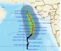
'Very severe cyclonic storm Biparjoy at 2330 hrs IST of 9th June over east-central Arabian Sea near lat 16.0N & long 67.4E. Likely to intensify further & move north-northeastwards during the next 24hrs,' the IMD said in a tweet.

By now, monsoon should have reached the central India, including parts of Madhya Pradesh, Rajasthan, eastern Uttar Pradesh and Gujarat, but it is yet to reach Maharashtra.

As heavy rains continue to lash Kerala, the India meteorological department on Friday issued an orange alert in eight districts in Kerala for Friday.

Authorities were on their toes in Banaskantha and Patan districts and relocated thousands of people residing in low-lying areas to safer places, they said.

The southwest monsoon season concluded on Saturday with India receiving 'below-average' cumulative rainfall -- 820 mm compared to the long-period average of 868.6 mm -- in an El Nino year.

The India meteorological department's Mumbai centre has predicted heavy to very heavy rainfall in the city and suburbs in the next 24 hours, with a possibility of occasional gusty winds reaching 50-60 kmph, the official said.


For Tuesday, the IMD said heavy to very heavy rains, with extremely heavy rainfall at isolated places, are likely over Assam and Meghalaya.

Delhi sweltered under intense heat as the Safdarjung observatory, considered the official marker of the national capital, noted a high of 43.8 degrees Celsius, four notches above the normal average.

Among the Sensex constituents, 18 stocks closed in negative with UltraTech Cement, L&T, Bharti Airtel, Bajaj Finance and Tech Mahindra being major laggards. Other heavyweights like Asian Paints, Maruti, Titan and JSW Steel also saw heavy selling. In contrast, Kotak Mahindra Bank, Bajaj Finserve, HDFC Bank, ITC and SBI bucked the trend and ended the session with a gain of up to 2.09 per cent.

The air quality is expected to improve further due to wind speed favourable for the dispersion of pollutants.

The five warmest years in Indian weather history have occurred in the past 14 years -- the others being 2009, 2017 and 2010, in order of intensity.