
The current spell of weak monsoon over the country is likely to continue for the next five days, the India Meteorological Department (IMD) said on Wednesday.

Heavy rains lashed Mumbai and its suburbs on Thursday, causing waterlogging on roads in some areas that led to traffic snarls and also delayed local train operations.

The red alert was issued for the second consecutive day. Rains have been lashing Mumbai and adjoining districts since Tuesday night.

The city's 24-hour Air Quality Index, recorded at 4 pm every day, stood at 418, up from 334 the previous day, and it may trigger stringent restrictions under the third stage of the graded response action plan to mitigate hazardous conditions.

The southwest monsoon is likely to arrive over Kerala on May 31, a day earlier than its normal onset date, the India Meteorological Department (IMD) said.

Some low-lying areas like the Andheri subway were submerged, forcing authorities to divert the traffic through alternate routes, civic officials said.

The IMD had initially predicted that Cyclone Nivar was likely to intensify into a 'severe cyclonic storm' but has now estimated that it will intensify further.

The weather department also said the national capital recorded only two rainy days this May, the lowest in 10 years.

The Indian Meteorological Department has issued a forecast predicting significant precipitation in the city throughout the week, casting a shadow over the series opener.

The cyclonic storm is likely to make landfall between Bhitarkanika National Park and Dhamra Port in Odisha early Friday with wind speeds of up to 120 kilometres per hour (kmph), it said.

'There was a slight change of direction towards north-eastwards which meant the impact of the cyclone on Mumbai was less severe than originally expected,' the IMD said in a statement.

The country saw 645 events of heavy rainfall and 168 events of very heavy rainfall in November, the highest in the month in five years, the India meteorological department said on Wednesday.

Weather scientists attribute the early onset of southwest monsoon over Kerala to the influence of the remnants of cyclone Asani that triggered the cross-equatorial flow, a key factor for the seasonal rains.

The IMD had said the Southwest Monsoon would hit parts of north India including Delhi on July 10, but it had not occurred till Sunday evening.

The IMD, in its onset date forecast on May 15, had said the monsoon is likely to hit the southern state on June 5, four days after its normal arrival.

Widespread rains lashed parts of Tamil Nadu on Thursday, prompting authorities to declare a holiday for schools in Chennai and many other districts.

In another forecast for August, IMD Director General Mrutunjay Mohapatra said monsoon is also likely to be normal in the month.

The southwest monsoon is set to make its exit in style, bringing rains to the parched parts of Uttar Pradesh and Bihar, as weather forecasters have picked up signs of formation of a cyclonic circulation over Bay of Bengal. Addressing a press conference in New Delhi, India Meteorological Department (IMD) director general Mrutyunjay Mohapatra on Thursday junked last week's forecast of early withdrawal of southwest monsoon and announced the extended stay of the seasonal showers. "Even though we expected early withdrawal of the southwest monsoon, a cyclonic circulation over west-central and adjoining northwest Bay of Bengal will shift the monsoon trough southwards around September 7.

According to an IMD forecast issued on Thursday, a heatwave spell will persist over northwest and central India during the next five days and over east India during the next three days.
The mean minimum temperature for November was 9.6 degree Celsius in 1938; nine degree Celsius in 1931 and 8.9 degree Celsius in 1930, according to IMD data. Normally, the mean minimum temperature for the month of November is 12.9 degree Celsius.

This deterioration in air quality led to prompting enforcement of Stage II of the Graded Response Action Plan (GRAP) in the national capital.

'We have not even used 0.1% of the available resources.'

The depression will intensify into a deep depression --- the third and fourth stage of any cyclone formation --- by this evening. It will intensify into a cyclonic storm by June 2, the Cyclone Warning Division of the IMD said.

Twelve out of the 15 warmest years since 1901 were during the past 15 years -- between 2006 and 2020, according to IMD data.

Heavy rains lashed Mumbai and its suburbs on Wednesday, causing flooding on roads and rail tracks and disrupting suburban train services as the south-west monsoon arrived in the city with a bang, while the India Meteorological Department (IMD) issued an alert for more downpour.

Mumbai and its adjoining areas were lashed by heavy showers on Tuesday, causing water-logging at a number of places, including railway tracks, which slowed the movement of trains and vehicles on roads.

There was no report of any major water-logging anywhere in the city so far.

India recorded 125 extremely heavy rainfall events during September and October of 2021, the highest in five years, owing to late withdrawal of the southwest monsoon and higher-than-normal low-pressure systems, India Meteorological Department (IMD) said on Tuesday.

Heatwave conditions are expected over northwest India during the next five days, with Punjab, Haryana, Rajasthan and Delhi predicted to bear the maximum impact, the India Meteorological Department (IMD) said on Thursday.

"This year, the Southwest Monsoon is likely to set over Kerala on May 31 with a model error of four days," the India meteorological department said on Wednesday.

Very light rains and thundershowers occurred at isolated places in Uttar Pradesh though, and a fresh warning of heavy showers was issued in Himachal Pradesh as the India Meteorological Department (IMD) said heavy to very heavy rainfall is likely in several parts of the country, including the northern region, over the next six-seven days.

India is likely to witness normal rainfall during the southwest monsoon season this year, the India Meteorological Department said on Thursday. Rainfall will be 96 per cent to 104 per cent of the Long Period Average (LPA) of 87 cm of the 1971-2020 period, it noted. Earlier, the IMD used to consider the LPA of 88cm of the 1961-2010 period.

The Mungeshpur weather station recorded a high of 48.8 degrees Celsius, eight notches above the normal. It recorded a minimum temperature of 27.6 degrees Celsius, a notch above the season's average.

Light to moderate rain in many areas with heavy rain at isolated places is likely to occur in West Bengal's coastal districts of North 24 Parganas, South 24 Parganas and Purba Medinipur.

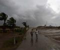
As heavy rains batter several parts of west and south India, the meteorological department on Friday said isolated extremely heavy falls are very likely over Konkan, Goa and central Maharashtra in the next two days.

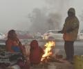
Data released by the IMD on Thursday showed that the mean minimum temperature (MMT) this December was 7.1 degrees Celsius.

All 80 people stuck at Pali waterfall in Goa's Sattari taluka were rescued on Sunday by the state's Fire and Emergency Services and the police, an official said.

The city went under cloud cover and witnessed incessant rainfall from afternoon, with parts of the city witnessing heavy rains and thunderstorms, civic officials said.
On June 2, wind speed will reach 40-50 kmph gusting to 60 over south Gujarat coast, with sea condition very likely to be "rough to very rough". On June 3-4, squally wind speed will reach 90-100 kmph gusting 110 kmph over Gujarat coasts, and the sea condition is very likely to be high to very high.
West Bengal Chief Minister Mamata Banerjee on Friday said that one person died in the state in cyclone Dana, even as the administration evacuated around 2.16 lakh people from the low-lying areas.