
The Met office had said Monday that significantly higher-than-normal temperatures may have an adverse impact on wheat and other crops.

The four-month monsoon season from June to September accounts for 75 per cent of rainfall in the country.

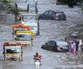
While there was a brief respite from the incessant downpour on Tuesday, collaborative efforts from the defence, national, and state disaster response forces took the lead in executing rescue and relief operations.

India recorded around 16 per cent more rainfall than normal in August, with rainfall over Northwest India recorded at 253.9 mm, the second highest in August since 2001, the India Meteorological Department (IMD) said on Saturday.

Mumbai recorded a minimum temperature of 16.5 degrees Celsius on Friday, the lowest for November in the last eight years, the India Meteorological Department (IMD) said. This temperature was recorded by the Santacruz observatory, which records weather parameters for Mumbai's suburbs. The Colaba observatory, which records weather parameters for the island city, registered a minimum temperature of 21.4 degrees Celsius during the same period. There is no cold wave alert for Maharashtra from November 30 to December 3, and temperature is set to rise.

Delhi is likely to receive the first monsoon showers on June 30 or July 1, India Meteorological Department (IMD) officials said on Tuesday.

The rainfall in July was minus seven per cent which comes to around 93 per cent of the Long Period Average, IMD Director General Mrutyunjay Mohapatra said.

The Met Office has issued a yellow alert, warning of moderate rain which could cause more problems to the residents of Delhi.

Cyclone Asna, formed over the coast of Kutch in Gujarat earlier during the day, has moved into the Arabian sea towards Oman without leaving any major impact on the region, officials said on Friday evening.

Wheat production during the current season is expected to be better than last year provided the weather remains favourable over the next few weeks, said senior industry executives. The weather had turned uncharacteristically hot in the latter half of last month, but owing to strong winds, the chill has returned in the last few days.

Manual horizontal digging will start soon in addition to the ongoing top-down drilling to rescue the 41 trapped workers in the Silkyara tunnel in Uttarkashi, the NDMA said on Monday.

No part of northwest, central and east India is likely to record a heatwave over the next five days, the MeT office said.

Western disturbances are near Pakistan-Afghanistan and are moving towards Delhi and thunderstorms or dust storms are likely to be experienced in northwest India, senior scientist at IMD RK Jenamani told ANI.

The southwest monsoon is expected to reach Kerala during the next two to three days, marking a sluggish start to the seasonal rains that are the lifeline of India's agri-based economy.

As Odisha and West Bengal are bracing for a severe cyclonic storm, governments of both states started evacuating people and while deciding to close educational institutions in vulnerable areas.

IMD has decided to increasingly use cutting-edge technology such as artificial intelligence (AI) and machine learning (ML) in forecasting, both to avoid such glitches and to counter the disruption of normal seasonal patterns as a result of climate change. It has formed various internal sub-groups of senior officials and meteorologists to decide on how best to use AI and ML in predicting cyclone intensity, and in making short-range weather forecasts (those valid for up to three hours) as well as long-range forecasts.

A fresh spell of heatwave is likely to begin over northwest India from May 7 and over central India from May 8, the India meteorological department said on Thursday.

Brace for some warmth this winter as the India Meteorological Department (IMD) in its December-February forecast on Thursday said that the minimum and maximum temperatures could remain 'normal' to 'above normal' over most parts of Northwest and Northeast India. Both the minimum and maximum will remain below normal in Southern Peninsular and Central India in these winter months. While this could give some respite from the intense cold of North India, it could have a negative impact on the standing rabi crops if the temperature rise is unusual and abnormal.

The Southwest Monsoon usually covers the entire country on July 8. The earlier normal date for the monsoon to cover the entire country was July 15.

With rainfall and monsoons becoming highly unpredictable partly due to climate change and partly due to usual changes in weather patterns, it is such innovations by IMD which will help in planning better, reports Sanjeeb Mukherjee.
A civic volunteer, identified as Chandan Das (31), died on the spot when he allegedly touched a live wire in Bud Bud in Purba Bardhaman district. The incident happened when he was out with a police team, they said.

However, there was no report of any major damage or casualty so far even as the landfall process started more than an hour ago, the official said.

The weather department said its latest model analysis had indicated that the moist easterly winds in the lower level from the Bay of Bengal would spread to northwest India, covering Punjab and Haryana by July 10, leading to the advancement of monsoon and an increase in rainfall activity over the region, including Delhi, from July 10 onwards.

IMD Director General M Mohapatra said there is cyclonic circulation along the Karnataka coast which is hindering the progress of the southwest monsoon.

The airport had temporarily suspended operations on Saturday due to strong winds and heavy rainfall caused by cyclones.

Conditions were becoming favourable for further advance of the southwest monsoon over some more parts of the south peninsula and east India and adjoining areas between June 18 and 21.

After its late withdrawal from northwest India, the southwest monsoon remains active over some parts of the country.

The India Meteorological Department (IMD) on Friday predicted 'moderate to heavy rainfall' for Mumbai city and its suburbs and the possibility of 'very heavy to extremely heavy' showers at isolated places in the next 24 hours.

The mean maximum temperature for the month of March was 28.2 degrees Celsius in 2020 and 2019. It was 32.8 degrees Celsius in 2018; 30.7 degrees Celsius in 2017 and 31.5 degrees Celsius in 2016, according to the India Meteorological Department data.

"We are expecting that the temperature will be higher than normal in the entire northwest India and the adjoining central India, starting with Gujarat, Rajasthan and up to east Madhya Pradesh and Chhattisgarh," he said at a virtual event on 'Building Climate Resilience for the Most Heat Vulnerable'.

Besides strengthening the IMD's infrastructure, Mohapatra said his priority will be to improve the dissemination of weather-related information -- from nowcasts to weather forecasts -- focus on sector-related forecast and give impact-based prediction in all areas.

IMD Director General Mrutunjay Mohapatra said the department's modelling indicate formation of a cyclonic storm around May 9, but its movement and intensification may be determined after the low pressure area actually forms on May 7.

Scores of people die every year due to cold waves that sweep across the north Indian plains.

Heavy rain in the first week of July compensated for the shortfall but caused flooding in many northeastern states.

The cyclonic storm is likely to move nearly westwards and cross north Andhra Pradesh-south Odisha coasts between Kalingapatnam and Gopalpur around Sunday evening, the Cyclone Warning Division of the IMD said.

Severe cyclonic storm Tauktae that is hovering over Saurashtra in Gujarat would move north-northeastwards and weaken gradually into a cyclonic storm during next three hours, informed the India Meteorological Department (IMD).

The minimum temperature in Delhi was recorded at 28.6 degrees Celsius, according to the India Meteorological Department (IMD).

The southwest monsoon over the country is likely to be normal in July, the India Meteorological Department (IMD) said on Thursday in its forecast for the month.

The sea conditions near the Odisha coast will become rough on May 9 and rougher on May 10.

Senior IMD scientist R K Jenamani said the monsoon covered south and central Arabian Sea, entire Kerala, parts of Karnataka and Tamil Nadu between May 31 and June 7.