
Cyclone Shakhti, the first cyclonic storm of the post-monsoon season in the Arabian Sea, has intensified.

The southwest monsoon arrived in Maharashtra on Sunday, making it the earliest onset of the annual rainfall season over the state in 35 years, according to the India Meteorological Department. The monsoon is expected to advance to Mumbai and some other parts over the next three days. The monsoon advanced into some more parts of the Arabian Sea, Karnataka, entire Goa, parts of Maharashtra, north Bay of Bengal, and parts of Mizoram, parts of Manipur and Nagaland on Sunday. The northern limit of monsoon passes through Devgad, Belagavi, Haveri, Mandya, Dharmapuri, Chennai, Aizawl and Kohima. Conditions are favorable for further advance into some more parts of central Arabian Sea, more parts of Maharashtra including Mumbai, Karnataka including Bengaluru, some parts of Andhra Pradesh, remaining parts of Tamil Nadu, more parts of west-central and North Bay of Bengal and some more parts of North Eastern states during next three days. The southwest monsoon hit Kerala on Saturday, marking its earliest arrival over the Indian mainland since 2009.

The India Meteorological Department (IMD) on Monday issued a warning of significant rainfall in Kerala due to cyclone Fengal, currently positioned as a strong low-pressure area over northern Tamil Nadu.

The very severe cyclonic storm was located over the east-central Arabian Sea located 840-kilometer west-southwest of Goa and 870 km west-southwest of Mumbai at 11.30 pm on June 8, the IMD said.

India on Thursday said it is closely watching the unfolding situation in the Red Sea, amid growing global concerns over Houthi militants stepping up attacks on several commercial ships in the region.

In a notice, IMD said, 'VSCS BIPARJOY over east-central Arabian Sea, lay centred at 0530hrs IST of 08th June, near lat 13.9N & long 66.0E, about 860km west-southwest of Goa, 910km southwest of Mumbai, would intensify further & move north-northwestwards.'

Minister of State for Defence Ajay Bhatt said in Lok Sabha the Navy deployed its units in the Gulf of Aden and East coast of Africa towards anti-piracy patrols since 2008 and a total of 3,440 ships and over 25,000 seafarers have been "safely escorted".

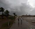
Villpuram district in north Tamil Nadu continued to reel under unprecedented flooding on Monday following extremely heavy rainfall, virtually blocking access to villages and residential colonies as bridges and roads overflowed, inundating huge acreage of standing crops and leaving passengers stranded as rail and road traffic was hit.

Indian Navy on Wednesday said its ships and aircraft remain 'mission deployed' for maintaining enhanced surveillance and undertaking maritime security operations.

The Navy said on Friday that the safety of the crew held hostage by armed pirates was ascertained and the Indian Navy warship continued to maintain its presence in the close vicinity of the vessel till its arrival in the territorial waters of Somalia.

Navy officials on Monday said that the swift response by the Indian Navy's mission deployed warship INS Sumitra ensured the safe release of the hijacked vessel and its crew.

The Indian Navy's 'mission deployed' guided missile destroyer INS Visakhapatnam responded to the attack within an hour of receiving a distress call from the vessel Genco Picardy, they said.

In a calibrated operation, the Indian Navy on Saturday 'coerced' 35 Pirates onboard a merchant ship around 1,400 nautical miles from the Indian coast to surrender and ensured the safe evacuation of 17 crew members without any injury, officials said.

The fresh incident comes amid growing global concerns over attacks on various commercial vessels in the Red Sea by the Houthi militants.

Cyclone 'Biparjoy' has an extensive damaging potential and it is likely to impact Kutch, Devbhoomi Dwarka and Jamnagar districts of Gujarat the most, the India meteorological department said on Tuesday.

The very severe cyclonic storm 'Biparjoy' intensified into an 'extremely severe cyclonic storm' and is likely to cross Saurashtra-Kutch and adjoining Pakistan coasts around the afternoon of June 15 as a 'very severe cyclonic storm (VSCS)', the India Meteorological Department said on Sunday.

The Indian Navy rescued an Iranian-flagged fishing vessel with 19 Pakistani crew members and a Sri Lankan trawler in two swift operations after armed pirates hijacked the boats in the Arabian Sea amid deteriorating security situation arising out of Iran-backed Houthi rebels targeting various cargo ships in the region.

The intensity of rainfall is likely to increase with the likelihood of very heavy falls at a few places and extremely heavy falls at isolated places on May 15, reports Sanjeeb Mukherjee.

External Affairs Minister S Jaishankar on Monday held wide ranging discussions with Iranian counterpart Hossein Amirabdollahian in Tehran and their discussion focused on the long term framework for India's involvement with the strategically vital Chabahar port and the North-South connectivity project.

Indian Navy's elite marine commandos on Friday rescued 21 crew members including 15 Indians from a bulk carrier in the North Arabian Sea and sanitised it in a swift operation while responding to an attempted hijacking of the Liberian-flagged vessel by around five-six armed personnel.

It will also be the third cyclone to hit the western state in June since 1965, the meteorological office said.

Meteorologists earlier said Cyclone 'Biparjoy' had been impacting the intensity of the monsoon and that its onset over Kerala would be 'mild'.

A cyclonic circulation lies over the southeast Bay of Bengal and the adjoining south Andaman Sea extending up to middle tropospheric levels. Under its influence, a low pressure area is very likely to form over the southeast Bay of Bengal and neighbourhood during the next 24 hours.

The IMD, in its onset date forecast on May 15, had said the monsoon is likely to hit the southern state on June 5, four days after its normal arrival.
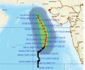
'Very severe cyclonic storm Biparjoy at 2330 hrs IST of 9th June over east-central Arabian Sea near lat 16.0N & long 67.4E. Likely to intensify further & move north-northeastwards during the next 24hrs,' the IMD said in a tweet.
On June 2, wind speed will reach 40-50 kmph gusting to 60 over south Gujarat coast, with sea condition very likely to be "rough to very rough". On June 3-4, squally wind speed will reach 90-100 kmph gusting 110 kmph over Gujarat coasts, and the sea condition is very likely to be high to very high.

Mumbai, its satellite cities, north and central Maharashtra and south Gujarat received rains on Wednesday owing to a low-pressure area in the Arabian Sea and a western disturbance, the India meteorological department said.

A depression over the southeast Arabian Sea, south of Porbandar in Gujarat, is likely to move northwestward and intensify into a cyclonic storm, the India Meteorological Department said on Tuesday.
Senior IMD scientist R K Jenamani said the monsoon covered south and central Arabian Sea, entire Kerala, parts of Karnataka and Tamil Nadu between May 31 and June 7.

The state government has begun preparations to deal with the fallout of the cyclone as it will bring very strong wind and heavy rainfall in the region, officials said.

The home minister held a video conference with Chief Ministers of Gujarat and Maharashtra -- Vijay Rupani and Uddhav Thackeray respectively -- and Administrator of Dadra and Nagar Haveli and Daman and Diu, Praful Patel, and assured them all central help in view of the impending cyclone, an official statement said in New Delhi.

Kerala has been receiving rainfall since Saturday and 10 out of the 14 weather monitoring stations in the state have received more than 2.5 mm rains.

After its late withdrawal from northwest India, the southwest monsoon remains active over some parts of the country.

Rain or thundershowers have also been predicted in south interior Karnataka and at a few places over Coastal Karnataka and North interior Karnataka.

Skymet says the IMD ignored the required criterion of two days of necessary rainfall to declare a proper onset of monsoon, reports Sanjeeb Mukherjee.

The weather office in Mumbai has sounded a cyclone alert for the coastal regions of south Gujarat and north Maharashtra, where it is expected to make a landfall in the early hours of Thursday.
The cyclonic circulation over southwest bay off south Tamil Nadu persists and now lies between 2.1 and 5.8 km above sea level.

Gale-force winds, heavy rainfall and high tidal waves swept the coastal belts of Maharashtra and Goa as Cyclone Tauktae hurtled northwards towards Gujarat.

The IMD has issued an orange alert for Mumbai, warning of very heavy rains at isolated places with strong winds on Monday as the very severe cyclonic storm Tauktae is likely to pass close to the Mumbai coast towards Gujarat.

The very severe cyclonic storm Tauktae is likely to intensify during the next 24 hours and reach the Gujarat coast on Monday evening, the India Meteorological Department (IMD) said.