
Mahindra & Mahindra (M&M) reported very strong results for the January-March quarter of the last financial year (Q4FY24), beating consensus comfortably. The margins of the automobile business improved 170 basis points (bps) year-on-year (Y-o-Y) to 8.8 per cent, while FES (Farm Equipment Sector) margins improved to 15.8 per cent (up 60 bps Y-o-Y), despite a decline in volumes due to cost optimisation and lower raw material costs.

IMD will present its month-wise and region-wise forecast in June.

On the eve of the redemption of India Millennium Deposits of $7.3 billion t the non-resident Indians, Finance Minister P Chidambaram
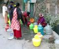
Deputy Chief Minister D K Shivakumar said the borewell in his house in Sadashivanagar in the state capital has gone dry for the first time. This happened despite the fact that Sadashivanagar is located next to Sankey Lake.

While the Aam Aadmi Party is contesting on four seats, the Congress has fielded candidates for the remaining three seats.

With different agencies showing divergent predictions regarding the southwest monsoon, the central government and states are gearing up to face adversity with various line ministries reportedly being directed to undertake mock drills and hold preparatory meetings. Around 56 per cent of the net cultivable area of the country is rain-fed, accounting for 44 per cent of foodgrain production. The June-September rains contribute around 73 per cent of the annual precipitation.

Over the past few days, deaths due to heat stroke have been reported from different parts of the country including Uttar Pradesh, Bihar and Odisha.

At the review meeting, chaired by cabinet secretary Rajiv Gauba in New Delhi, the IMD said above normal maximum temperatures are likely over most parts of northeast, east and central India and some parts of northwest India.

After a steady surge, prices of pulses, except those of urad and masoor to some extent, are showing signs of stabilising amid a revival of monsoon rains over major growing areas of Maharashtra and Karnataka, and on expectations of a rise in imports. Chana prices, which too had moved up in recent months, have dropped by almost 3 per cent since the end of August due to increased liquidation of government stocks, official data shows. Monsoon rains seem to have benefitted the standing soybean crop as well.

Landslides and flash floods triggered by incessant rain in Himachal Pradesh have paralysed normal life.

The IMD has predicted moderate showers in Mumbai on Tuesday and high intensity rains in neighbouring Raigad.

Unseasonal rain coupled with lightning and thunderstorm lashed parts of Mumbai in the wee hours of Thursday, bringing some respite from the hot and humid weather in the city, civic officials said.

A punishing cold wave swept Delhi on Monday morning with the minimum temperature at the Safdarjung observatory, the city's base station, plunging to 1.4 degrees Celsius, the lowest in the month since January 1, 2021.

The mercury soared to 46.2 degrees Celsius at Najafgarh, making it the hottest place in the capital.

A railway official said around 20 trains were delayed by 15 minutes to 2 hours in the morning.

The IMD on its part is sticking to its forecast of July rainfall.

The weather office cautioned the fishermen not to venture into sea in the Odisha Coast.

'While every year presents new challenges, it also provides opportunities for better growth and performance.'

Delhi's minimum temperature on Wednesday morning plunged to 4.4 degrees Celsius -- the season's lowest -- making the national capital colder than Dharamsala, Nainital and Dehradun.

The trough over the Bay of Bengal, which has caused the torrential downpour in the state, will weaken in next 48 hours.

The IMD defines a normal monsoon as one which delivers between 96 and 104 per cent of the 50-year average rainfall for the season.

States have been told to prepare in advance to counter any impact of an adverse southwest monsoon.

The country also reported 1,750 deaths due to extreme weather events such as floods, cyclonic storms, heavy rain, landslides, lightning, among others, during the year, it said.

The India meteorological department said another western disturbance is likely to bring storms and rain to the northern plains, including Delhi, over the next few days.

The system, which moved towards Bangladesh from north Bay of Bengal at a speed of 56 kmph caused moderate to heavy rain and squally weather in West Bengal's coastal districts of South 24 Parganas, North 24 Parganas and Purba Medinipur, dampening festive spirits on Deepavali and Kali Puja.

The duo used their mobile phone to establish contact for their rescue, following which an NDRF team was roped in.

After a stellar run on the bourses that saw tractor stocks rise up to 52 per cent, analysts are turning cautious on the sector as muted demand trends may weigh in the near-term. Total volumes in the tractor segment for the last three quarters of the current financial year (9MFY24) have remained weak with VST Tillers, Escorts Kubota, and M&M seeing declines of 21 per cent, 5 per cent, and 3 per cent year-on-year (Y-o-Y), respectively, during the period, amid patchy rainfall, delayed crop harvest, and lower reservoir level. Across industry, total domestic sales volume so far in the current financial year (April '23 to January '24) has declined 5 per cent Y-o-Y, as per Tractor Manufacturers Association (TMA).

The onset of the southwest monsoon is being keenly watched this year as it may provide an early sign regarding its progress over the Indian subcontinent, particularly when El Nio is expected to rear its head during the latter half of the season.

Commuters on some routes, including the Harbour line that operates services between Panvel and Chhatrapati Shivaji Maharaj Terminus (CSMT), complained of delay in train operations in the morning hours.

A 22-year-old person was killed and another one injured on Thursday after a tree fell on their hut in Mumbai as moderate to heavy rains lashed the city and its suburbs in the last 24 hours, officials said.

The local train traffic on the Central and Western Railway routes was mostly normal though the trains were running a few minutes late, railway officials said.

It said the weather system was expected to intensify into a deep depression by 5.30 am on Wednesday and turn into Cyclone Mocha in the next 12 hours, packing wind speeds of 80-90 kmph and gusting to 100 kmph.

This time, Delhi saw a sharp improvement in air quality just ahead of Diwali which can be attributed to intermittent rainfall on Friday and wind speed favourable for the dispersion of pollutants.

Cyclone Vayu was to hit the Gujarat coast on Thursday, but it changed course on the intervening night of Wednesday and Thursday.

Rijiju, who was removed as law minister on Thursday, refused to answer questions about his previous ministry contending that they were no longer relevant and that he looked forward to serve in the Earth Sciences Ministry.

As the heavy rains continued on Wednesday also, Orange alert was sounded in 12 of the 14 districts of the state for the day.

The rains were being caused due to a cyclonic circulation lying over north east Arabian sea and adjoining Saurashtra and Kutch regions, the IMD said in its bulletin.

The cyclone is expected to make landfall on Thursday evening as a 'very severe cyclonic storm' with maximum wind speed reaching up to 150 kilometres per hour, the India Meteorological Department (IMD) said.

The event, for which people had started gathering since morning, began around 11.30 am and went on till around 1 pm. That day, the nearest weather station to the spot of the programme recorded a maximum temperature of 38 degrees Celsius.