
The city also witnessed cold wave conditions, as the minimum temperature was less than 10 degrees Celsius and five notches below normal, according to Mahesh Palawat, an expert at Skymet Weather, a private forecasting agency.

Monsoon normally starts withdrawing beginning September 1 from west Rajasthan.

Delhi is likely to receive the first monsoon showers on June 30 or July 1, India Meteorological Department (IMD) officials said on Tuesday.
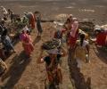
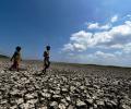
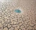
Around 40 per cent of the country is staring at drought-like conditions ahead of the monsoon as water levels have receded sharply.

Assocham-Skymet report says untimely rain may reappear in north India.
Some low-lying places like Hindmata, and areas in Dadar and Sion, including the Gandhi Market and road number 24 in Sion, were inundated, forcing pedestrians to wade through the water and making it difficult for motorists to commute.

The mercury breached the 46-degree Celsius mark in several places such as Allahabad (46.8 degrees Celsius) and Jhansi (46.2 degrees Celsius) in Uttar Pradesh; Sports Complex (46.4 degrees Celsius) in Delhi; Ganganagar (46.4 degrees Celsius) in Rajasthan; Nowgong (46.2 degrees Celsius) in Madhya Pradesh; and Maharashtra's Chandrapur (46.4 degrees Celsius).

According to an IMD forecast issued on Thursday, a heatwave spell will persist over northwest and central India during the next five days and over east India during the next three days.
Conditions are becoming favourable for advance of southwest monsoon over the southern part of Andaman Sea, Nicobar Islands and adjoining southeast Bay of Bengal during May 18-19, the IMD said.

The bounteous monsoon this year has already dumped 1159.4 mm of rainfall in Delhi till Thursday afternoon, the highest since 1964 and the third-highest ever, according to the IMD data
Between June 1 and July 28, about 32 per cent of the 685 districts in the country did not receive adequate rainfall.

Parts of Uttar Pradesh, Haryana, and Punjab have also been impacted.

However, the areas under paddy - the biggest cereal grown during the kharif season - continue to be less than last year, mainly due to delayed onset of rains and also on account of shift towards the more lucrative maize.

They are worried at more than one forecast of a possibly weak monsoon, reports Dilip Kumar Jha.

Close to half the country is experiencing deficient rains and the shortage for the figure has gone up to 16 per cent.

Monsoon is likely to reach Maharashtra and Goa in the next two days, the India Meteorological Department said on Monday, with a private weather forecasting agency predicting sustained heavy rains later this week.

Till Thursday, the country had received 41 per cent less June rainfall than normal - the scantiest in a decade and one of the rarest occasions when the shortfall in the month was more than 30 per cent - private weather forecaster Skymet said in its daily weather forecast on Friday.

Till June 30, the southwest monsoon was 33 per cent lower than normal, which is among the worst in the last five years, with 28 of the 36 meteorological divisions recording deficient rain.

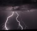
'After the 4th of May we can expect thunderstorms, dust storms and some rain over a large area of north India.'
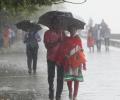
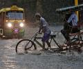
Incessant rains continued to lash Mumbai city and neighbouring districts on Saturday, throwing normal life out of gear even as weathermen predicted heavy showers across the state for Sunday.

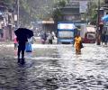
Incessant rain has lashed parts of Mumbai on Tuesday morning, disrupting local train services and road traffic with water logging in several low-lying areas. The weatherman has predicted widespread rainfall in the state during the next 36 hours.

A private sector weather forecaster, Skymet, and some global forecasters have already issued warnings for this year that this could happen.

Moderate to heavy showers will continue over Mumbai for next 48 hours.

Normally, monsoon reaches Delhi by June 27. It covers the entire country by July 8. Last year, the wind system had reached Delhi on June 25 and covered the entire country by June 29.

In what could come as a major disappointment for fans across the globe, awaiting the highly anticipated clash between India and Pakistan at the Eden Gardens, the city of Kolkata witnessed rains and drizzle on Saturday morning.

A sudden change in weather brought respite to the residents of national capital New Delhi as gusts of wind carrying thick dust blew across the region on Saturday afternoon.
What stocks will gain from a normal monsoon?

The country witnessed the rainiest day of this winter with almost all parts receiving showers, the weatherman said, attributing it to a series of weather conditions.

'Cyclone Nisarga will pass by Mumbai, Thane, Kalyan, Panvel and Navi Mumbai by a safe distance,' says Air Vice Marshal G P Sharma (retd), President, Meteorology and Climate Change, Skymet Weather Services,

The Ayanagar weather station recorded 122.8 mm between 8.30 am on Wednesday and 8.30 am on Thursday, which was 11 times the normal rainfall.

The NSE Nifty, after shuttling between 10,331.80 and 10,227.45, finally settled 196.75 points, or 1.94 points higher at 10,325.15.

The IMD said that there has been an increase in the rainfall activity in Kerala and monsoon could hit the state anytime now.
'The first two months of monsoon are not looking good.' 'In case both the halves fail, it is going to be misery.'
Rain for the central and northwestern parts a concern.

This interactive maps shows you the rainfall received across India in the months of June and July.

Officials in the weather department said the monsoon is expected to be below normal because of the El-Nino effect.
Total area impacted across India pegged at 18.9 mn hectares.

Contrary to some predictions, rainfall is adequate so far.

Till July 26, kharif crops have been sown in around 68.87 million hectares, which is 6.43 per cent lower than the area covered during the same period last year.

A likely western disturbance over north India during the weekend might cause heavy to very heavy showers in a few places, including New Delhi.