
The India Meteorological Department (IMD) forecasts the withdrawal of the southwest monsoon from northwest India around September 15. This year's monsoon covered the country earlier than usual, resulting in surplus rainfall and extreme weather events.

The Met office has issued a "red" warning for Delhi, Haryana, Punjab and west Rajasthan, stressing the need for "extreme care for vulnerable people".

Heatwave conditions are expected over northwest India during the next five days, with Punjab, Haryana, Rajasthan and Delhi predicted to bear the maximum impact, the India Meteorological Department (IMD) said on Thursday.

Temperatures in 17 locations breached 45 degrees Celsius on Monday, with the punishing heat affecting health and livelihoods.

Several deaths were reported across the country due to rain-related incidents like lightning strikes and drowning.

'Dense' to 'very dense' fog prevailed in parts of Punjab, Haryana, west Rajasthan, Bihar, Delhi, west Uttar Pradesh, Jharkhand, Odisha and Assam.

According to the police, one of the accused had made IEDs and later tested them at several places in Delhi, Rajasthan and Haldwani in Uttarakhand.

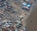
Rajasthan's three districts -- Jalore, Sirohi and Barmer -- are reeling under a flood-like situation due to heavy rainfall caused by cyclonic storm Biparjoy, an official said on Sunday.

The southwest monsoon season concluded on Saturday with India receiving 'below-average' cumulative rainfall -- 820 mm compared to the long-period average of 868.6 mm -- in an El Nino year.

The weather department has said that the skies are expected to be partly cloudy for the next few days in Delhi.

The southwest monsoon might finally start withdrawing from parts of North-West India over the next three days, signaling the end of its four-month journey over the country that started in June, the India Meteorological Department (IMD) said. However, though the retreat might begin from next week, the rains might not descend quickly, as the met department predicted fresh spells of rains in Vidarbha, Chhattisgarh and east MP on September 21-22 and over Odisha, Coastal areas north Andhra Pradesh and Gangetic West Bengal on September 19-21. "Due to anti-cyclonic flows over northwest India at lower tropospheric levels, dry weather is very likely over west Rajasthan, Punjab, Haryana, Chandigarh and Delhi during the next five days. "Hence conditions are becoming favourable for the withdrawal of Southwest Monsoon from parts of northwest India during next three days," the IMD said.

The south-west monsoon on Tuesday started withdrawing from parts of south-west Rajasthan and adjoining Kutch in Gujarat, with at least eight states, including rice bowl states of Uttar Pradesh and Bihar reporting deficient rains. It was for the first time since 2016 that the monsoon started withdrawing in the third week of September. "Southwest monsoon has withdrawn from parts of southwest Rajasthan & adjoining Kutch today, against its normal date of withdrawal from southwest Rajasthan of September 17," the India Meteorological Department (IMD) tweeted.

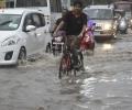
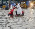
The national capital has been witnessing an incessant spell of light to moderate rain for the past two days.

In Delhi, Safdarjung, the base station for the national capital, recorded 44.2 degrees Celsius, while Mungeshpur observatory in northwest Delhi, reported 47.3 degrees Celsius.

Western disturbances are near Pakistan-Afghanistan and are moving towards Delhi and thunderstorms or dust storms are likely to be experienced in northwest India, senior scientist at IMD RK Jenamani told ANI.

"We are expecting that the temperature will be higher than normal in the entire northwest India and the adjoining central India, starting with Gujarat, Rajasthan and up to east Madhya Pradesh and Chhattisgarh," he said at a virtual event on 'Building Climate Resilience for the Most Heat Vulnerable'.

Climate change has hampered the ability of the forecasting agencies to accurately predict severe events and weather bureaus across the world are focusing on augmenting the observational network density and the weather prediction modelling to improve predictability, India Meteorological Department (IMD) Director General Mrutyunjay Mohapatra has said.

The mercury breached the 46-degree Celsius mark in several places such as Allahabad (46.8 degrees Celsius) and Jhansi (46.2 degrees Celsius) in Uttar Pradesh; Sports Complex (46.4 degrees Celsius) in Delhi; Ganganagar (46.4 degrees Celsius) in Rajasthan; Nowgong (46.2 degrees Celsius) in Madhya Pradesh; and Maharashtra's Chandrapur (46.4 degrees Celsius).

According to an IMD forecast issued on Thursday, a heatwave spell will persist over northwest and central India during the next five days and over east India during the next three days.

The IMD, in its review for the month, said the observed monthly average maximum, minimum and mean temperature for the country as a whole during March this year are 32.65 degrees Celsius, 19.95 degrees Celsius and 26.30 degrees Celsius, respectively, against the normal 31.24 degrees Celsius, 18.87 degrees Celsius and 25.06 degrees Celsius based on the climatology period 1981-2010.

The Southwest Monsoon usually covers the entire country on July 8. The earlier normal date for the monsoon to cover the entire country was July 15.
As many as 45 people have been killed due to cyclone Tauktae across 12 districts of Gujarat, officials.

It rained in the periphery of Delhi -- Aligarh in Uttar Pradesh and Karnal in Haryana -- but clouds hovered over the national capital, without giving any relief from the heat.

Cyclone Tauktae weakened into a 'depression' and lay centred over south Rajasthan and adjoining Gujarat region on Wednesday morning, the India Meteorological Department said.

Sowing had started on a sluggish note in several parts of the country because of delay in the onset of the monsoon but has picked up pace subsequently as the rains progressed and performed appreciably well in August.

The weather department said its latest model analysis had indicated that the moist easterly winds in the lower level from the Bay of Bengal would spread to northwest India, covering Punjab and Haryana by July 10, leading to the advancement of monsoon and an increase in rainfall activity over the region, including Delhi, from July 10 onwards.

All sub-regions have been receiving good rainfall except the North-east and east region of the country, where the deficiency has reached 23 per cent.
"The season averaged maximum temperatures in Himachal Pradesh, West Rajasthan, Konkan, Goa, Coastal Karnataka, Kerala and Arunachal Pradesh are likely to be higher than normal by 0.5-1.0 degree Celsius," the Met department has said in its forecast.

Twelve of the 36 meteorological subdivisions recorded deficient rainfall, while the rest witnessed normal to excess rain. In total, 38 per cent of the 662 districts received below-normal rain.

In another forecast for August, IMD Director General Mrutunjay Mohapatra said monsoon is also likely to be normal in the month.

Data from department of agriculture showed that kharif crops had been sown in around 31.56 million hectares till Friday, which was 104.25 per cent more than the same period last year. Acreage of almost all crops was higher than last year.

The state broadcasters have started the practice, but private news channels may follow suit, a ministry source said.
The southwest monsoon over the country is likely to be normal in July, the India Meteorological Department (IMD) said on Thursday in its forecast for the month.

Could the defeat of Vasundhara Raje, Shivraj Singh Chouhan, and Raman Singh in last year's polls in Rajasthan, Madhya Pradesh, and Chhattisgarh, respectively, augur a transition in the command structure of these states, where they reigned supreme?

Monsoon normally starts withdrawing beginning September 1 from west Rajasthan.
'Southwest Monsoon has advanced into remaining parts of Rajasthan, Haryana and Punjab and thus it has covered the entire country today, the 26th June 2020,' the IMD said in its special Daily Weather Report.

This should augur well for the rabi crops as delayed withdrawal will leave enough moisture in the soil for early sowing.

As of now, monsoon rains are deficient by 21 per cent across India, affecting sowing of kharif crops. Karnataka, Maharashtra, Gujarat, Haryana, Punjab and West Rajasthan have been the worst-hit regions this year.

A likely western disturbance over north India during the weekend might cause heavy to very heavy showers in a few places, including New Delhi.

The national capital battled weather conditions in the "red category" as the maximum temperature recorded at the Palam observatory was 46.1C,