
The southwest monsoon has arrived in Mumbai 16 days before its usual date, making it the earliest arrival since 1950. This early onset follows the monsoon's arrival in Kerala, the southernmost state, on Saturday, marking the earliest arrival since 2009. The India Meteorological Department (IMD) predicts an above-normal rainfall for the 2025 monsoon season, with rainfall between 96 per cent and 104 per cent of the 50-year average of 87 cm considered 'normal'. The monsoon is crucial for India's economy, providing vital water for agriculture and replenishing reservoirs.
The IMD issued a "Nowcast" warning, forecasting thunderstorms accompanied by lightning and intense spells of rain with gusty winds reaching 50-60 kmph at isolated places in Mumbai in the next three to four hours.

Mumbai recorded a minimum temperature of 16.5 degrees Celsius on Friday, the lowest for November in the last eight years, the India Meteorological Department (IMD) said. This temperature was recorded by the Santacruz observatory, which records weather parameters for Mumbai's suburbs. The Colaba observatory, which records weather parameters for the island city, registered a minimum temperature of 21.4 degrees Celsius during the same period. There is no cold wave alert for Maharashtra from November 30 to December 3, and temperature is set to rise.

IMD officials said the maximum temperature in the three districts could go up to 38 degrees Celsius.

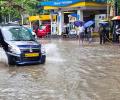
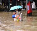
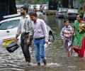
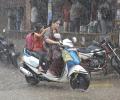
Incessant rains with intermittent spells of moderate to heavy showers since Friday morning have slowed down public transport services and traffic in Mumbai.
Flight services at Mumbai airport were severely impacted on Monday due to low visibility after heavy rains in the city, leading to runway operations being shut for over an hour and approximately 50 flights being cancelled, sources said.

A sudden downpour in Delhi caught citizens off guard and caused heavy waterlogging and traffic jams on Tuesday while Mumbai breathed a sigh of relief as showers stopped a day after heavy rain brought the metropolis to its knees.

The weather bureau has issued a red alert for neighbouring Raigad and Palghar districts predicting heavy to very rainfall at a few places and extremely heavy rain at isolated places for Wednesday. An orange alert is sounded for Thane district.

A 22-year-old person was killed and another one injured on Thursday after a tree fell on their hut in Mumbai as moderate to heavy rains lashed the city and its suburbs in the last 24 hours, officials said.

Incessant heavy rain lashed Mumbai, prompting the meteorological department to upgrade the 'orange' alert to 'red' with effect from Wednesday night till Thursday afternoon, officials said.
The BMC declared a holiday for all government and private schools and colleges in Mumbai on Thursday after the IMD issued a 'red' alert for the metropolis.

Commuters on some routes, including the Harbour line that operates services between Panvel and Chhatrapati Shivaji Maharaj Terminus (CSMT), complained of delay in train operations in the morning hours.

The India Meteorological Department (IMD) on Friday predicted 'moderate to heavy rainfall' for Mumbai city and its suburbs and the possibility of 'very heavy to extremely heavy' showers at isolated places in the next 24 hours.

The orange alert implies that authorities should be ready to handle situations arising out of severe weather.

In August 1998, the observatory had received 261.9 mm rainfall in 24 hours which was a record for the month till now, but Wednesday's rain broke it within only 12 hours.

Between 8.30 am and 11 am, the IMD's Colaba observatory (representative of south Mumbai) recorded 79.4 mm rainfall, while the Santacruz observatory (representative of suburbs) recorded 44.5 mm rain, she said.

Apart from the metropolis, several other parts of Maharashtra also reported a drop in night temperatures, resulting in chill and cool breeze in those areas.

The India meteorological department has issued an orange alert for Mumbai, Thane, Palghar and other coastal districts in Maharashtra, stating it is very likely that 'heavy to very heavy' rainfall will occur in isolated places in this region.

The IMD has forecast heavy rainfall in some parts of the state in next 48 hours. "The southwest monsoon has arrived in Maharashtra. The onset line is passing over Harnai, Solapur, Ramagundum (Telangana) and Jagdalpur (Chhattisgarh)," IMD Mumbai centre's deputy director general K S Hosalikar said.

Mumbai civic body took to Twitter to inform citizens about the do's and don'ts and asked them to "stay hydrated and safe".

The cyclone is likely to bring heavy rainfall in its wake in parts of Maharashtra, Gujarat and Goa. The light showers/drizzle in parts of Mumbai city, its suburbs and neighbouring districts of Thane and Palghar on Monday morning brought some respite to people from the sweltering heat and humidity.
According to disaster management control room of the civic body, no injury or casualty has been reported so far.

Tropical storm 'Tauktae' (pronounced as Tau'Te) which had intensified into a very severe cyclonic storm, lies close to the Gujarat coast, the India Meteorological Department said. "The landfall process has started and will continue during next two hours," the IMD said.
However, some areas in south Mumbai, which witnessed a record rain on Wednesday, were still water-logged, they said. The India Meteorological Department (IMD) has predicted moderate to heavy rainfall in the city and suburbs and intense showers in some parts of the Mumbai Metropolitan Region in next 24 hours.

Schools and colleges in the city and adjoining districts have been closed as a precautionary measure.

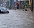
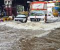
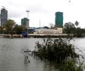
Heavy rains lashed Mumbai and its suburbs on Wednesday, causing flooding on roads and rail tracks and disrupting suburban train services as the south-west monsoon arrived in the city with a bang, while the India Meteorological Department (IMD) issued an alert for more downpour.

The India Meteorological Department (IMD) has forecast 'extremely heavy rains' at a few places in Marathwada, Mumbai and other parts of the coastal Konkan region of Maharashtra in the next 24 hours.

The Santacruz observatory recorded 286.4 mm rainfall during the 24-hour period ending at 8.30 am on Wednesday, making it the fourth highest rainfall in Mumbai since 1974, an Indian Meteorological Department official said.
Officials however warned of a 4.81 metre high tide in afternoon coupled with heavy showers, which may cause flash floods in low-lying areas in the city.

The Indian Meteorological Department, meanwhile, warned of intense spell of 30 to 50 mm rainfall per hour with strong winds in Mumbai and suburban areas.

The two western states, already battling a raging pandemic, which has put their health infrastructure under severe strain, opened new fronts to tackle the fallout of the storm which is expected to make a landfall close to Mumbai on Wednesday. They are likely to be impacted most by the cyclone.
Moderate to heavy showers will continue over Mumbai for next 48 hours.

However, flight operations at the Mumbai airport were not impacted due to rains, an airport official said.

An alert of "very heavy" rainfall in Mumbai has been issued by the Indian Meteorological Department's regional centre on Tuesday, with the rains expected to intensify in the next 24 hours.
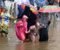
Waterlogging was reported from areas like Dadar, Wadala, Worli, Kurla, Chembur, Bandra, Andheri, Kandivili, Vikhroli, Kanjurmarg and Bhandup, among others.

In an unprecedented measure, the Maharashtra government requested defence officials to arrange airlift of the stranded passengers of the 17412 Mahalaxmi Express.

Mumbai received 231.4 mm rain in the last 24 hours, while Thane received 229.81 mm.