
Delhi Chief Minister Arvind Kejriwal on Wednesday urged the Centre to intervene to ensure that levels of the Yamuna, flowing at an all-time high of 207.55 metres, don't rise further.

According to Ministry of Earth Science's air quality monitor 'SAFAR', the air quality is likely to improve from Friday onwards due to better wind speed.

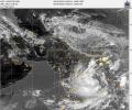
Cyclone Biparjoy has left a trail of destruction in Gujarat's Kutch and Saurashtra regions as some 1,000 villages are still without power with hundreds of electric poles getting damaged, while several coastal villages were flooded due to heavy rains and incoming seawater, officials said on Friday, a day after the storm made landfall.

'As the Indian economy continues to expand over the next three years, mid- and small-caps should do well as they have higher exposure to the domestic economy than large-caps.'

In Delhi, Safdarjung, the base station for the national capital, recorded 44.2 degrees Celsius, while Mungeshpur observatory in northwest Delhi, reported 47.3 degrees Celsius.
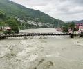
Incessant rains unleashed more death and destruction on Monday in parts of north India, with 37 people killed in landslides and other rain-related incidents in the last two days even as the Army and NDRF teams stepped in to intensify the relief and rescue operations.

The IMD has issued Yellow alert for Thiruvananthapuram, Kollam, Pathanamthitta, Alappuzha, Kottayam, Ernakulam, Idukki, Thrissur, Malappuram and Kozhikode districts for today whereas Wayanad too has Yellow alert on May 22.

Delhi's primary weather station, the Safdarjung Observatory, registered a maximum temperature of 40.4 degrees Celsius, four notches higher than normal.

With the cooling down of heatwaves as the monsoon spreads across the country, power demand has fallen by 12.5 per cent from the start of this month till Monday. Peak power demand of the country had touched a record of 210 Gw last week, mostly due to rising temperatures and opening up of the economy. Compared with the beginning of this month, almost all states have seen a fall in power demand. Punjab, however, is an exception where the power demand on Monday was 17 per cent higher than on June 1.

Delhi's minimum temperature on Wednesday morning plunged to 4.4 degrees Celsius -- the season's lowest -- making the national capital colder than Dharamsala, Nainital and Dehradun.
The maximum sustained wind speed is 55 knots gusting to 65 knots around system centre. Sea condition is rough to very rough, it stated.

As many as 12 teams were deployed and five teams were on standby in West Bengal while additional teams are also in readiness if required.

The Safdarjung Observatory, which provides representative data for the city, recorded a maximum temperature of 40.1 degrees Celsius, which was eight notches more than normal, said Kuldeep Srivastava, the head of the IMD's regional forecasting centre.

Delhi environment minister Gopal Rai on Monday said the ban on construction and demolition activities in Delhi will continue till further orders in view of the high air pollution levels.

'If because of El Nino, the monsoon is affected adversely in the current year, naturally it will affect income projections and consequently Budget numbers.'

The four-month monsoon season from June to September accounts for 75 per cent of rainfall in the country.

A depression has formed over the Bay of Bengal and it will cross the coast between Tamil Nadu and Andhra Pradesh by early November 19, the India meteorological department said on Thursday, as rains lashed Chennai and its neighbouring districts, with forecast of more spells.

The southwest monsoon is expected to reach Kerala during the next two to three days, marking a sluggish start to the seasonal rains that are the lifeline of India's agri-based economy.

Mumbai and its adjoining areas were lashed by heavy showers on Tuesday, causing water-logging at a number of places, including railway tracks, which slowed the movement of trains and vehicles on roads.

A total of 435 people died in the country due to extreme weather events during the last three months of the southwest monsoon, according to the data compiled by the India meteorological department.

Cyclone Biparjoy made landfall near Jakhau Port in Gujarat on Thursday evening with a wind speed of 115-125 kmph gusting to 140 kmph as heavy rains lashed the coastal region, where several areas plunged into darkness due to power cuts and a large number of trees, electric poles and hoardings got uprooted.

The Southwest Monsoon is set to arrive early with the Andaman and Nicobar Islands expected to receive first seasonal showers on May 15, the weather office said on Thursday.

The India Meteorological Department has classified light rain between 2.5 and 7.5 mm; moderate rain (7.6-35.5 mm); heavy rain (35.6-64.4 mm); and extremely heavy rain (64.5 - 124.4 mm).

The national capital, parts of which reeled under heatwave conditions for the past few days, had some relief on Wednesday with strong winds and partly cloudy skies witnessed during the day.

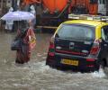
Incessant showers lashed Mumbai and its neighbouring areas on Wednesday morning, leading to flooding in many low-lying areas and traffic snarls on roads, officials said.

A fresh spell of heatwave is likely to begin over northwest India from May 7 and over central India from May 8, the India meteorological department said on Thursday.

As the kharif season is setting in, India is scrambling to source fertilisers from the international market. It is set to sign long-term contracts - especially with Morocco and Latin American countries - to ensure steady flow of supplies. "We have to source fertilisers wherever it is available because crops have to be secured.
Kerala has been receiving rainfall since Saturday and 10 out of the 14 weather monitoring stations in the state have received more than 2.5 mm rains.

Officials at the India Meteorological Department said winds gusting up to 20 kmph on Sunday and 25 kmph on Monday led to a marked improvement in the air quality and improved visibility.
The rest of Maharashtra was very likely to get rain and thundershowers in isolated places during this period, the official informed.

Large parts of north India reeled under numbing cold on Tuesday with the mercury remaining below freezing point at most places in Jammu and Kashmir, while dense fog in the early hours of the morning hit road and rail traffic movement.

Severe cyclonic storm Mandous will cross the coast between north Tamil Nadu and south Andhra Pradesh around December 9 night and early next day, the regional weather office said on Friday.

The India Meteorological Department has issued an 'orange' alert.

Low temperature -- Delhi recorded a minimum of 13.5 degrees Celsius on Tuesday, the season's lowest so far -- allowed accumulation of pollutants, said Mahesh Palawat, vice president (meteorology and climate change), Skymet Weather.

Three national highways in Kutch, Navsari and Dang districts were blocked due to damage caused by rains. Fifty one state highways and over 400 panchayat roads have also been damaged, state Disaster Management Minister Rajendra Trivedi told reporters.

The weather department attributed the unusual heat to the lack of rainfall due to the absence of active western disturbances over north India and any major system over south India.

Heavy downpour continued in various parts of Gujarat on Tuesday and six people died in rain-related incidents in the last 24 hours, raising the toll to 69 since June 1, officials said.

Authorities in Tamil Nadu and Puducherry have taken a slew of measures to handle the situation arising out of the cyclonic storm, which has led to heavy rainfall in several regions.

It's still early days, but the southwest monsoon has been nearly 37 per cent 'below normal' in the first seven days (June 1-7) of this month. According to the data furnished by the India Meteorological Department (IMD), between June 1 and June 7, India received 14.5 millimetres (mm) of rainfall, against a 'normal' 23.1 mm. Among places where rains have arrived, monsoon in Kerala in the first seven days has been 48 per cent 'below normal', while in Puducherry, it has been 56 per cent 'above normal'. In Tamil Nadu, rains were 21 per cent 'above normal' between June 1 and June 7.

The southwest monsoon might finally start withdrawing from parts of North-West India over the next three days, signaling the end of its four-month journey over the country that started in June, the India Meteorological Department (IMD) said. However, though the retreat might begin from next week, the rains might not descend quickly, as the met department predicted fresh spells of rains in Vidarbha, Chhattisgarh and east MP on September 21-22 and over Odisha, Coastal areas north Andhra Pradesh and Gangetic West Bengal on September 19-21. "Due to anti-cyclonic flows over northwest India at lower tropospheric levels, dry weather is very likely over west Rajasthan, Punjab, Haryana, Chandigarh and Delhi during the next five days. "Hence conditions are becoming favourable for the withdrawal of Southwest Monsoon from parts of northwest India during next three days," the IMD said.