
More than twice as much global glacier mass will remain if countries restrict temperature rise to 1.5 degrees Celsius, compared to the warming level of 2.7 degrees Celsius resulting from the current policies, says a new study released.

A cold wave has gripped many parts of north and east India, with Srinagar recording a minimum temperature of minus 5.3 degrees Celsius. Other areas experiencing below-freezing temperatures include Gulmarg, Pahalgam, Konibal, Qazigund, Kupwara, and Kokernag in Kashmir. Himachal Pradesh has issued an orange warning for severe cold wave conditions in several districts. Delhi recorded a minimum temperature of 5.9 degrees Celsius, while Faridkot in Punjab was the coldest in the region at 0 degrees Celsius. Extreme cold conditions also continued in parts of Rajasthan and Jharkhand. The Met office has forecast mainly dry weather until December 26, with the possibility of light snowfall in the higher reaches of Kashmir on the intervening night of December 21-22.

The family members of the missing persons who have been camping at the site for the past seven days have now lost hope and are praying for the recovery of bodies to perform last rites.
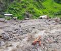
Five people were killed and about 50 missing following several incidents of cloudburst in Himachal Pradesh where rains washed away many houses, bridges and roads, officials said on Thursday.

Satellite imagery showed a dense elongated band of fog stretching from Punjab to the northeast.

A blinding layer of dense fog over north India, including Delhi, caused major inconvenience to commuters. The visibility levels were 50 metres around 5:30 am.

It will also be the third cyclone to hit the western state in June since 1965, the meteorological office said.

The state has suffered losses of Rs 4,000 crore and the figure is likely to go up as estimates continue to pour in, he said.

Mercury hovered around 40 degrees Celsius in large parts of the country on Monday as the Indian meteorological department predicted heat wave conditions in parts of east India over the next four days and the northwest region over the next two days.

The Northern Railways said it has cancelled around 17 trains and diverted around 12 others, while traffic has been suspended at four locations due to waterlogging.

Delhi saw seven cold wave days in January 2020, while it did not record any such day last year.

Large parts of north India reeled under numbing cold on Tuesday with the mercury remaining below freezing point at most places in Jammu and Kashmir, while dense fog in the early hours of the morning hit road and rail traffic movement.

The entire coastal region of Odisha has been experiencing rainfall since Friday night.

A moderate intensity earthquake jolted Kashmir valley early on Tuesday.

The temblor, which had its epicentre in southwestern Afghanistan, was felt in Islamabad, Rawalpindi, Peshawar, Lahore and the tribal areas.

Cold wave continued unabated in Uttar Pradesh as 13 more people succumbed to the chill in the state, taking the death toll this winter to 129.
A moderate earthquake struck Kashmir valley on Thursday afternoon triggering panic among the residents.
A collection of the best photos from around the world in the last 24 hours

Usually, the annual monsoon forecast is released around mid-April.

Telangana has been witnessing high temperatures for several days now and the highest maximum temperature of 43 degree Celsius was recorded.
An earthquake measuring 4.9 on the Richter scale rocked parts of West Bengal in the early hours of Wednesday, the meteorological department said in Kolkata.
The cold conditions on Wednesday tightened its grip in Punjab and Haryana with minimum temperature dropping to five degrees Celsius below normal, even as most parts of the region were engulfed with fog and mist disrupting normal life.
Most parts of the north India on Tuesday experienced a chilly day as mercury dropped further by a few notches amid foggy conditions, with the national capital recording its lowest temperature this season.
Post-monsoon rains continued to lash Pune and most parts of western Maharashtra on Wednesday, affecting normal life and damaging crops. The city recorded 75 mm rains till Tuesday night, accompanied by strong winds, Medha Khole, director of Meteorological office, said. According to the Directorate of Agriculture, heavy downpour in Kolhapur, Sangli and Satara districts have adversely affected crops like grapes and cotton.Vehicular traffic was badly affected in the city.
As Myanmar grapples with crises in the aftermath of deadly cyclone Nargis, another tropical storm appears headed for its shores, the India Meteorological Department said on Wednesday. The IMD, which is the Regional Specialised Meteorological Centre of the World Meteorological Office, has issued a advisory on the impending extreme weather condition. The United Nations has warned that the Myanmar could face a 'second catastrophe'.
The south-west monsoon is likely to hit the national capital in a day or two as pre-monsoon showers drenched the city on Tuesday, bringing respite to denizens who have been braving an intense heat wave for the past week. Various parts of the city received rains during the past 12 hours, which brought down the temperature to tolerable levels around 25 degree Celsius, the Meteorological office said. The city has received over 10 mm of rains in the past three days.

The crucial Jammu-Srinagar highway has been blocked
Squally weather with wind speed reaching 55-65 kmph was likely to prevail along and off the Orissa coast, the sources said.
It was likely to move in a west-north-westerly direction and weaken gradually, triggering heavy rains in interior parts of the state.
Several schools in the state declared a holiday as traffic was disrupted due to inundation of low-lying areas.
Pathankot, Bathinda, Amritsar, Ambala and Sonipat, continued to witness foggy conditions in the morning.
Delhi experienced the second coldest day after Monday's 3.1 Celsius.
Trains and flights were affected due to poor visibility caused by dense fog, official sources said.
Waves measuring up to 14 feet and accompanied by strong winds were witnessed in Dubai, Ajman, Sharjah and Port Rashid.
It occurred at 0630 IST. It was felt in Kolkata, North & South 24 Parganas, Nadia, Hoogly, Barddhaman, East & West Midnapore districts of Bengal and Puri, Cuttack, Jajpur, Jagatsinghpur, Kendrapara, Balasore, Mayurbhanj and Ganjam districts of Orissa
Disruption of road, rail and air traffic was the order of the day as a dense fog reduced visibility in large parts of north India.

Heavy to very heavy rainfall was expected over north Coastal Tamil Nadu and Puducherry in the next 24 hours.