Mini cloud bursts are marked by intense short spells which may not exceed 10cm in one hour-a classical definition by India Meteorological Department, he noted.

Over 20,000 people were evacuated to safer places in these three districts. State capital Mumbai too witnessed water-logging in many areas after overnight rains on Thursday.

The India meteorological department has issued an orange alert for Mumbai, Thane, Palghar and other coastal districts in Maharashtra, stating it is very likely that 'heavy to very heavy' rainfall will occur in isolated places in this region.

The forecast has an error margin of four days, which is considered normal

The storm would continue to move north-northwestwards, intensify further and reach north Bay of Bengal near West Bengal and the adjoining north Odisha and Bangladesh coasts by the morning of May 26

Prime Minister Narendra Modi on Wednesday undertook an aerial survey of affected areas in Gujarat and the adjoining Union territory of Diu to assess the devastation caused by Cyclone Tauktae.

According to Central Pollution Control Board's (CPCB) Sameer app, the city's air quality index (AQI) stood at 449 in the severe category at 8 am on Saturday. It was 462 on Friday.
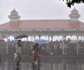
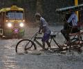
As heavy rains batter several parts of west and south India, the meteorological department on Friday said isolated extremely heavy falls are very likely over Konkan, Goa and central Maharashtra in the next two days.

Heavy rains had battered the metropolis on Sunday and Monday as well.

Ernakulam district authorities on Tuesday said 350 cumecs of the water from Idamalayar, which reached Periyar river but there was no considerable rise in the water-level.
The IMD had said the Southwest Monsoon would hit parts of north India including Delhi on July 10, but it had not occurred till Sunday evening.

According to the officials of Tirumala Tirupati Devasthanams, one of their sanitary workers was badly injured due to the storm and calamitic conditions in the state.

After its late withdrawal from northwest India, the southwest monsoon remains active over some parts of the country.

' Number of school hours per day may be reduced. Sports and other outdoor activities which expose students directly to the sunlight may be appropriately adjusted in the early morning'

The cyclone expected to weaken gradually over the next two days.

The system lay centered at 5.30 am over Southeast Bay of Bengal, about 450 km west-northwest of Car Nicobar (Nicobar Islands), 380 km west of Port Blair (Andaman Islands), 970 km southeast of Visakhapatnam (Andhra Pradesh) and 1030 km south-southeast of Puri (Odisha).

Many years during which monsoons were poor saw high returns, while normal or excess rainfall has also coincided with poor calendar year gains.

Just two days after recording 811.6 mm of rainfall in a day, Cherrapunji in Meghalaya received a bountiful 972 mm of precipitation in 24 hours ending 8.30 am on Friday, the highest in June since 1995 and the third highest in 122 years, the India Meteorological Department (IMD) said.
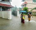
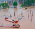
The heavy rains led to water level in various dams in the state rising to the red alert mark, prompting the government to open one of the shutters of Cheruthoni dam of Idukki reservoir in the afternoon.

The IMD, in its review for the month, said the observed monthly average maximum, minimum and mean temperature for the country as a whole during March this year are 32.65 degrees Celsius, 19.95 degrees Celsius and 26.30 degrees Celsius, respectively, against the normal 31.24 degrees Celsius, 18.87 degrees Celsius and 25.06 degrees Celsius based on the climatology period 1981-2010.

A cyclonic circulation lies over the southeast Bay of Bengal and the adjoining south Andaman Sea extending up to middle tropospheric levels. Under its influence, a low pressure area is very likely to form over the southeast Bay of Bengal and neighbourhood during the next 24 hours.

The Navy has has kept five flood teams and three diving teams on stand-by in Mumbai, the official said. These teams, trained and equipped for rescue operations, are stationed at various naval areas across Mumbai and can provide early response over a larger area, he said.
Though early days, meteorologists point towards a neutral La Nina during the initial phase of the four-month monsoon season this year that starts from June. If this holds true, by the time the rains hit the mainland, it could mean there would be one less reason to worry about the prospects of the monsoon this year. Weathermen said making any accurate prediction of how El Nino will behave and what impact it can have on the progress and distribution of rains is difficult to say at this point. A clear picture will emerge around late May or early June.

Severe cyclonic storm Tauktae that is hovering over Saurashtra in Gujarat would move north-northeastwards and weaken gradually into a cyclonic storm during next three hours, informed the India Meteorological Department (IMD).

The city has been witnessing heavy rains since Tuesday night, resulting in water logging in many areas.

IMD issued red alerts for Thiruvananthapuram, Kollam, Pathanamthitta, Alappuzha, Kottayam, Ernakulam and Idukki districts.

The mercury in Delhi, which recorded its hottest day of the year so far at 45.6 degrees Celsius on Sunday, came down to 42.4 degrees Celsius, according to the India meteorological department.

With the owners one after the other parking their vehicles, the bridge was lined up with swanky cars on both sides of the overpass presenting a never before seen spectacle, civic workers said.

According to a report prepared by the NGO, 106 people have died due to cold in Delhi between January 1 and January 19.

The city also witnessed cold wave conditions, as the minimum temperature was less than 10 degrees Celsius and five notches below normal, according to Mahesh Palawat, an expert at Skymet Weather, a private forecasting agency.

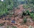
Heavy overnight rains in Uttar Pradesh on Friday led to the deaths of at least 22 people, including nine labourers who were buried alive under the debris when an under-construction wall in the state capital collapsed on their huts.

The IMD has forecast heavy rainfall in some parts of the state in next 48 hours. "The southwest monsoon has arrived in Maharashtra. The onset line is passing over Harnai, Solapur, Ramagundum (Telangana) and Jagdalpur (Chhattisgarh)," IMD Mumbai centre's deputy director general K S Hosalikar said.

The current spell of weak monsoon over the country is likely to continue for the next five days, the India Meteorological Department (IMD) said on Wednesday.

The depression will intensify into a deep depression --- the third and fourth stage of any cyclone formation --- by this evening. It will intensify into a cyclonic storm by June 2, the Cyclone Warning Division of the IMD said.

'Already, the temperature has touched 39 degrees in some parts of Gujarat and now we are in the last week of February.' 'We need to activate the heat action plan from March 1.'

The rainfall in July was minus seven per cent which comes to around 93 per cent of the Long Period Average, IMD Director General Mrutyunjay Mohapatra said.

Climate change has hampered the ability of the forecasting agencies to accurately predict severe events and weather bureaus across the world are focusing on augmenting the observational network density and the weather prediction modelling to improve predictability, India Meteorological Department (IMD) Director General Mrutyunjay Mohapatra has said.

Maharashtra Chief Minister Eknath Shinde reviewed the rain situation on Tuesday and said over 3,500 people had been shifted to safer places from flood-prone and vulnerable spots across the state, where several districts, including Mumbai, experienced downpour.

It was a repeat of scenes witnessed last month as motorists struggled to manoeuvre their vehicles on flooded roads and subways while showers led to traffic congestion in Chennai and suburbs.

The India Meteorological Department (IMD) said parts of South Delhi reported hailstorm around 7.30 am. More rain and hailstorms are predicted during the day, it said.