
Delhi recorded its coldest January morning in three years with the minimum temperature dropping to 3 degrees Celsius. Cold wave conditions are expected to persist, and air quality has deteriorated to the 'very poor' category.

The early onset of the southwest monsoon brought continuous rainfall across southern and eastern India, contributing to this record.

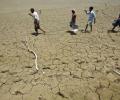
Heatwave conditions are expected over northwest India during the next five days, with Punjab, Haryana, Rajasthan and Delhi predicted to bear the maximum impact, the India Meteorological Department (IMD) said on Thursday.

Ten to 20 days of heatwave are expected against the normal of four to eight days in the entire April-June period.

Heatwave conditions have been prevailing in Odisha since April 15 and the Gangetic West Bengal since April 17, according to the MeT department.

According to weather officials, wind speeds along and off the Odisha-West Bengal coasts are anticipated to reach 60 km/h from October 23, increasing to 120 km/h from October 24 night to October 25 morning.

Local people had hoped that all the floodwater would be cleared by Friday but the opposite occurred.

Intense heat swept through east India and parts of the southern peninsular region on Thursday, testing power grids and prompting the Kerala government to order closure of educational institutions till May 6.

The IMD said that rainfall over India in August and September would be around 106 percent of the long-period average of 422.8 mm.

The heat wave is likely to impact parts of Jammu and Kashmir, Himachal Pradesh, Uttarakhand, Punjab, Haryana, Delhi, Rajasthan, Madhya Pradesh, Jharkhand, Odisha and Gangetic West Bengal, the Met office said.

The El Nino impact on the Indian monsoon typically manifests by way of extended break in rainfall.

It is in more than a decade that the IMD has predicted 'above-normal' rains in the country.

'There will not be very heavy rain.' 'Moderate showers will be there and winds will be, say, somewhere between 20 and 40 km/hr, gusting to 35 km/hr.'

The Met office has issued a "red" warning for Delhi, Haryana, Punjab and west Rajasthan, stressing the need for "extreme care for vulnerable people".

Lakhs of voters will have to bear the searing heat when they step out to exercise their franchise in the second phase of the Lok Sabha elections on Friday.

The national capital, parts of which reeled under heatwave conditions for the past few days, had some relief on Wednesday with strong winds and partly cloudy skies witnessed during the day.

'It is very likely to move nearly northwards for next few hour and recurve slowly north-northeastwards along Narsapur, Yanam, Kakinada, Tuni and Visakhapatnam coasts during noon to evening on Wednesday and emerge into west central Bay of Bengal off North Andhra Pradesh coasts by night,' the India Meteorological Department said in its national bulletin.

The IMD, in its review for the month, said the observed monthly average maximum, minimum and mean temperature for the country as a whole during March this year are 32.65 degrees Celsius, 19.95 degrees Celsius and 26.30 degrees Celsius, respectively, against the normal 31.24 degrees Celsius, 18.87 degrees Celsius and 25.06 degrees Celsius based on the climatology period 1981-2010.
Rain deficiency in eastern and western Uttar Pradesh, Bihar, Jharkhand, Gangetic West Bengal, Assam and Meghalaya is 20-46 per cent less than normal as of June 17.

Heavy overnight rains lashing the metropolis submerged many low-lying localities today even as the weatherman forecast heavy rainfall in the districts of Gangetic West Bengal.

The southwest monsoon season concluded on Saturday with India receiving 'below-average' cumulative rainfall -- 820 mm compared to the long-period average of 868.6 mm -- in an El Nino year.

The storm has claimed 27 lives in Bangladesh and Myanmar.

Mercury hovered around 40 degrees Celsius in large parts of the country on Monday as the Indian meteorological department predicted heat wave conditions in parts of east India over the next four days and the northwest region over the next two days.

The low-pressure area over the South Andaman Sea and adjoining southeast Bay of Bengal is very likely to move northwestwards and intensify into a depression by Saturday, the weather office said.

Odisha has issued a fresh flood alert in wake of heavy rains under influence of cyclone Komen

The weather system over the South Andaman Sea and the adjoining southeast Bay of Bengal is very likely to move north-westwards and strengthen into a depression by Saturday, the Met Department said.

The southwest monsoon might finally start withdrawing from parts of North-West India over the next three days, signaling the end of its four-month journey over the country that started in June, the India Meteorological Department (IMD) said. However, though the retreat might begin from next week, the rains might not descend quickly, as the met department predicted fresh spells of rains in Vidarbha, Chhattisgarh and east MP on September 21-22 and over Odisha, Coastal areas north Andhra Pradesh and Gangetic West Bengal on September 19-21. "Due to anti-cyclonic flows over northwest India at lower tropospheric levels, dry weather is very likely over west Rajasthan, Punjab, Haryana, Chandigarh and Delhi during the next five days. "Hence conditions are becoming favourable for the withdrawal of Southwest Monsoon from parts of northwest India during next three days," the IMD said.

Odisha is bracing for heavy rainfall early next week under the impact of a possible cyclone in the Bay of Bengal, which is likely to skirt the state and move towards West Bengal and Bangladesh, the Indian Meteorological Department (IMD) said on Friday.

After its late withdrawal from northwest India, the southwest monsoon remains active over some parts of the country.

Trade and market players have already started factoring in at least 10 million tonnes drop in production in rice in the kharif season as compared to last year due to delayed sowing.

The current spell of weak monsoon over the country is likely to continue for the next five days, the India Meteorological Department (IMD) said on Wednesday.

The system lay centered at 5.30 am over Southeast Bay of Bengal, about 450 km west-northwest of Car Nicobar (Nicobar Islands), 380 km west of Port Blair (Andaman Islands), 970 km southeast of Visakhapatnam (Andhra Pradesh) and 1030 km south-southeast of Puri (Odisha).
Rainwater, which clogged most of the city links almost, disrupted surface transport with trams out of service for the second day on Wednesday.
Fifteen persons were killed and over 300 injured in a severe cyclonic storm that lashed West Bengal's south 24 Parganas and east Midnapore districts in the early hours on Wednesday.

Cyclonic storm Yaas is very likely to make landfall near Balasore in north Odisha with a speed of 155 kmph to 165 kmph, gusting to 185 kmph, around noon on May 26, the Met department said.

After a making a slow progress, the southwest monsoon is expected to gain momentum and advance further into several parts of drought-hit Maharashtra and central India.

The entire coastal region of Odisha has been experiencing rainfall since Friday night.

The Eastern Railway has cancelled the departure of Howrah-New Delhi AC Special Express for Wednesday.

The weather office cautioned the fishermen not to venture into sea in the Odisha Coast.

The cyclone, according to an IMD report early Sunday, is developing into a severe cyclonic storm over the Bay of Bengal and can potentially become a very severe cyclonic storm in the next 24 hours, S N Pradhan, the chief of NDRF said in New Delhi.