
Meanwhile, the Indian National Centre for Ocean Information Services (INCOIS) issued high sea waves, up to 4.7 metres high, warning across several coastal districts.

Severe cyclonic storm 'Montha' has begun making landfall off the Andhra Pradesh coast, with the process expected to continue for the next three to four hours. The storm is expected to cross the coast between Machilipatnam and Kalingapatnam, near Kakinada, with wind speeds of 90-100 kmph.

The worst-hit districts include Kendrapara, Balasore and Bhadrak, while the human casualty 'still stands at zero,' he told reporters in Bhubaneswar.
A civic volunteer, identified as Chandan Das (31), died on the spot when he allegedly touched a live wire in Bud Bud in Purba Bardhaman district. The incident happened when he was out with a police team, they said.

However, there was no report of any major damage or casualty so far even as the landfall process started more than an hour ago, the official said.

According to weather officials, wind speeds along and off the Odisha-West Bengal coasts are anticipated to reach 60 km/h from October 23, increasing to 120 km/h from October 24 night to October 25 morning.

Three members of the same family survived the horrific train accident in Odisha's Balasore and returned to their home in West Bengal.

Two coaches of the Visakhapatnam-Palasa Passenger train from the rear and the loco of Visakhapatnam-Rayagada Passenger were derailed as a result of the accident, the railway official said, adding that rescue operations are underway.

IMD Director General Mrutunjay Mohapatra said the department's modelling indicate formation of a cyclonic storm around May 9, but its movement and intensification may be determined after the low pressure area actually forms on May 7.

Odisha is facing a morgue crunch as a large number of unclaimed dead bodies from Balasore's triple train accident, have piled up at its mortuaries.

Earlier on Tuesday, Odisha Special Relief Commissioner Pradeep Kumar Jena said that cyclone Asani is likely to reach Kakinada on the Andhra coast on Wednesday morning.
The weather system moved west-northwestward and concentrated into a depression on Saturday at 8.30am, close to west of Andaman Islands, the bulletin said.

Balasore district hospital looked like a war zone with the injured lying on stretchers in the corridor and rooms bursting at its seams with extra beds propped up.

The train crash happened near the Bahanaga Baazar station in Balasore district, about 250 km south of Kolkata and 170 km north of Bhubaneswar, around 7 pm on Friday, prompting the Railway Ministry to order a probe.

The low-pressure area over the South Andaman Sea and adjoining southeast Bay of Bengal is very likely to move northwestwards and intensify into a depression by Saturday, the weather office said.

A month ahead of the annual Rath Yatra, on July 12, the Odisha government on Thursday announced that this year, too, devotees will be barred from participating in the festival, which will only be held in Puri amid strict adherence to COVID-19 protocols.
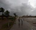
Odisha is bracing for heavy rainfall early next week under the impact of a possible cyclone in the Bay of Bengal, which is likely to skirt the state and move towards West Bengal and Bangladesh, the Indian Meteorological Department (IMD) said on Friday.

'It is very likely to move nearly northwards for next few hour and recurve slowly north-northeastwards along Narsapur, Yanam, Kakinada, Tuni and Visakhapatnam coasts during noon to evening on Wednesday and emerge into west central Bay of Bengal off North Andhra Pradesh coasts by night,' the India Meteorological Department said in its national bulletin.

The weather system over the South Andaman Sea and the adjoining southeast Bay of Bengal is very likely to move north-westwards and strengthen into a depression by Saturday, the Met Department said.

Railway officials also indicated that possible 'sabotage' and tampering with the electronic interlocking system, which detects the presence of trains, led to the Friday accident.

The system lay centered at 5.30 am over Southeast Bay of Bengal, about 450 km west-northwest of Car Nicobar (Nicobar Islands), 380 km west of Port Blair (Andaman Islands), 970 km southeast of Visakhapatnam (Andhra Pradesh) and 1030 km south-southeast of Puri (Odisha).

According to an official, two fresh deaths have been reported in Cuttack and Khurda districts of the state.

IMD director general Mrutunjay Mohapatra said that cyclone Asani has already achieved maximum stage of intensification and is gradually getting weakened.
'Yaas' is likely to cross the Odisha-West Bengal coasts between Paradip and Sagar Islands around noon on May 26 as a very severe cyclonic storm with wind speeds of 155-165 kmph, Kolkata's Regional Meteorological Centre Deputy Director Sanjib Bandopadhyay said.

An Indian Air Force transport carrier 'C-130J Super Hercules' with 20 Odisha Fire Services personnel onboard will provide help to the authorities in the East Jaintia Hills.

Odisha government has declared lightning as a state-specific disaster.

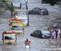
Orissa government on Wednesday assessed the loss of about Rs 2,121 crore due to the recent floods which killed at least 41 persons and damaged over one lakh houses even as people in 198 villages continued to remain marooned for the last fortnight.

The location of the landfall is north of Dhamra and south of Bahanaga, close to Bahanaga block, on the coast, around 50 km of Balasore, he said.

Prime Minister Narendra Modi on Friday reviewed the post-cyclone situation and damages caused by Cyclone Yaas in the state at a meeting in Bhubaneswar where Odisha government demanded long term solutions to mitigate problems of repeated cyclones and provision of disaster resilient power systems.
The high-flood situation in the Mahanadi river system in Orissa did not cause as much damage as feared even though the rivers were flowing above their danger levels.

Flood waters engulfed vast areas of the delta region of Mahanadi river system in Odisha even as the death toll due to heavy rains and floods in the state climbed to 34.

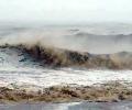
The India Meteorological Department said rainfall would be accompanied by gale wind speed reaching 140 to 150 kmph and gusting to 165 kmph along and off Odisha and north Andhra Pradesh coasts.

The cyclone, according to an IMD report early Sunday, is developing into a severe cyclonic storm over the Bay of Bengal and can potentially become a very severe cyclonic storm in the next 24 hours, S N Pradhan, the chief of NDRF said in New Delhi.

The nationwide death toll on Friday rose to 2005 as the intense heat wave continued to sweep many parts of the country, with Palamau in Jharkhand recording the highest temperature of 47 degrees Celsius.
The depression, which was initially over west-central Bay of Bengal and adjoining areas, moved westward and intensified into a deep depression.

A day after Cyclone Yaas tore through coastal Odisha and Bengal to cause havoc as far as Jharkhand, tornadoes, torrential rains, bridge collapses and swelling rivers continued to plague eastern India as people tried to pick up their lives amid the debris of swept away mud homes and swamped farmlands.

The IMD has also issued a red-coded warning alert to the Odisha and West Bengal coasts.

West Bengal and Odisha have evacuated lakhs of people from vulnerable areas to safety as severe cyclonic storm 'Yaas' is nearing the coast and is expected to make landfall near Dhamra Port in Bhadrak district early on Wednesday morning.

The power infrastructure and the farm sector have also suffered a considerable damage, Chief Secretary A K Tripathy said. However officials said the telecom infrastructure is largely intact.

The ministry of home affairs in its advisory on December 28 had advised states and Union Territories that they can impose local restrictions, including night curfew, based on their assessment of the situation to contain the spread of COVID-19.