The India Meteorological Department (IMD) forecasts above-normal rainfall for India in September, following a monsoon season marked by heavy downpours and related disasters in various regions. The forecast indicates normal to above-normal rainfall for most areas, with some exceptions in the northeast, east, extreme south peninsular India, and parts of northwest India.

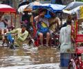
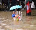
Heavy rains caused severe waterlogging, traffic jams, and disruptions to local train services in Mumbai. Schools and colleges were closed due to a 'red alert' issued by the IMD.
The early onset of the southwest monsoon brought continuous rainfall across southern and eastern India, contributing to this record.

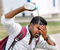
Ten to 20 days of heatwave are expected against the normal of four to eight days in the entire April-June period.
Heatwave conditions have been prevailing in Odisha since April 15 and the Gangetic West Bengal since April 17, according to the MeT department.

Lakhs of voters will have to bear the searing heat when they step out to exercise their franchise in the second phase of the Lok Sabha elections on Friday.

Some India states are likely to record a significantly higher number of heatwave days, according to the national weather body.
After remnants of cyclone Gulab that hit the eastern coast of the country brought torrential rains to central Maharashtra, a senior India Meteorological Department official said on Wednesday that we are witnessing a rare occurrence as the weather system might generate another cyclonic storm.

The IMD had said the Southwest Monsoon would hit parts of north India including Delhi on July 10, but it had not occurred till Sunday evening.

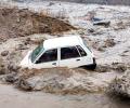
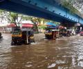
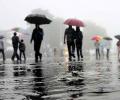
The India Meteorological Department (IMD) has forecast 'extremely heavy rains' at a few places in Marathwada, Mumbai and other parts of the coastal Konkan region of Maharashtra in the next 24 hours.

Till June 30, the southwest monsoon was 33 per cent lower than normal, which is among the worst in the last five years, with 28 of the 36 meteorological divisions recording deficient rain.

Low pressure over south-central Maharashtra and south Konkan is likely to move over the Arabian Sea and intensify into a depression in the next 48 hours, the India meteorological department said on Thursday. Under the influence of this cyclonic circulation, heavy rains are expected over the ghat areas of Maharashtra, Konkan and south Gujarat during the next two days, the IMD said.

The India meteorological department has stated that day temperatures are likely to be above normal by 0.5 degree Celsius, reports Sanjeeb Mukherjee.

The India Meteorological Department, which had issued a red colour-coded alert for north India for May 25-26 when the prevailing heatwave conditions are expected to peak, said dust and thunderstorms are likely to bring some relief on May 29-30.

IMD has said the temperature in April-June across most parts in India is expected to be 0.5-1 degrees Celsius warmer than normal. However, doctors and scientists say they haven't found any direct correlation between the speed of COVID-19 spread and warm weather.
According to disaster management control room of the civic body, no injury or casualty has been reported so far.

Heavy to very heavy rains are expected in Maharashtra, Gujarat, west Madhya Pradesh and Goa in the next couple of days, the India Meteorological Department said.

The Indian Meteorological Department, meanwhile, warned of intense spell of 30 to 50 mm rainfall per hour with strong winds in Mumbai and suburban areas.

Southwest Monsoon was vigorous/active over East Rajasthan and the Gujarat region during many days and over West Rajasthan, Konkan and Goa and Madhya Maharashtra on a few days of the week ending July 11.

The slow progress of the south-west monsoon has led to overall deficiency of rains by 22 per cent over the last fortnight, the meteorological department on Wednesday said.
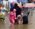
Waterlogging was reported from areas like Dadar, Wadala, Worli, Kurla, Chembur, Bandra, Andheri, Kandivili, Vikhroli, Kanjurmarg and Bhandup, among others.
The monsoon this year in India was likely to be 'below normal' at 95% of LPA: Skymet

The seasonal temperature would be above normal by more than one degree Celsius over Northwest India.

Flight operations at the Mumbai airport were suspended for nearly half an hour as visibility dropped well below the required 550 meter-mark
In the first of a two-part series, Business Standard examines the impact of the upcoming summer on agriculture and drinking water supply.
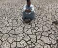
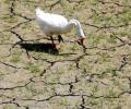
India now faced a higher likelihood of a drought in some parts, as monsoon rain would be less than predicted in April, private weather forecaster Skymet said on Friday.