The extremely severe cyclonic storm 'Amphan' on Monday turned into a super cyclonic storm, only the second over the Bay of Bengal in two decades, and is spiralling towards Indian shores, prompting West Bengal and Odisha governments to start evacuating people from vulnerable areas, officials said.
The National Disaster Response Force (NDRF) has deployed 37 teams in the coastal areas of the two states, its chief S N Pradhan said.
Prime Minister Narendra Modi reviewed the situation with Union Home Minister Amit Shah and top government officials in New Delhi, as the impending super cyclone compounded the its worries at a time when it is grappling with mounting COVID-19 deaths and cases.
The India Meteorological Department Director General M Mohapatra said that Cyclone Amphan is a very intense storm which can wreak large-scale damage.
Amphan is expected to make a landfall on May 20 between the Digha islands in West Bengal and Hatia islands of Bangladesh, Mohapatra said at a press briefing.
"Cyclone Amphan is very intense. It has the potential to wreak large-scale damage," Mohapatra said.
It is likely to de-intensify to an extremely severe cyclonic storm when it makes a landfall. The wind speed during the landfall is likely to be 165-175 kilometres per hour gusting upto 195 kilometres per hour.
"It is very likely to move north-northeastwards across northwest Bay of Bengal and cross West Bengal – Bangladesh coasts between Digha (West Bengal) and Hatiya Islands (Bangladesh) close to Sundarbans during the afternoon / evening of May 20 as an extremely severe cyclonic storm,” Mohapatra said.
He added that the coastal districts of West Bengal will receive heavy to extremely heavy rainfall on May 19 and 20. This includes East Medinipur, South and North 24 Parganas, Howrah, Hooghly and Kolkata in West Bengal.
Storm surge of about 4-6 metres above astronomical tide is likely to inundate low lying areas of South and North 24 Parganas and about 3-4 metres over the low lying areas of East Medinipur district of West Bengal during the time of landfall.
Coastal Odisha is likely to experience light to moderate rainfall at many places. Rainfall at most places with heavy to very heavy rainfall at a few places over north coastal Odisha -- Jagatsinghpur, Kendrapara, Jajpur, Balasore, Bhadrak and Mayurbhanj districts-- and isolated heavy falls over Khordha and Puri districts on May 19.
Isolated heavy rainfall is expected over north Odisha -- Bhadrak, Balasore, Mayurbhanj, Jajpur, Kendrapara and Keonjhar districts -- on May 20.
An unspecified number of people were evacuated from coastal areas of Odisha where Jagatsinghpur, Kendrapara, Bhadrak and Balasore were likely to experience heavy rainfall accompanied by high-velocity winds, particularly on May 19 and 20, Mohapatra said.
The meteorological department, which has issued an 'orange message' for West Bengal, warned of extensive damage in Kolkata, Hooghly, Howrah, South and North 24 Parganas and East Midnapore districts.
Disruption of rail and road link are likely at several places but that will not have a major impact on human lives as only skeletal traffic ply the roads and railway tracks.
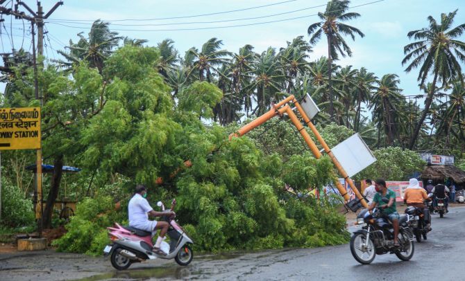
Large-scale damage to communication and electricity lines, crops and houses is feared, official sources said.
Official reports reaching Kolkata said 40,000 people have already been evacuated from South 24 Parganas district.
"Storm surge of 4 to 5 metres above astronomical tide is likely to inundate low lying areas of South and North 24 Parganas and about 3 to 4 metres over low lying areas of East Midnapore district of West Bengal during the time of landfall," Das said.
Prime Minister Narendra Modi assured all possible central assistance to the states likely to be hit by the cyclone.
'Reviewed the preparedness regarding the situation due to cyclone Amphan. The response measures as well as evacuation plans were discussed. I pray for everyone's safety and assure all possible support from the central government,' Modi tweeted soon after the meeting.
He also reviewed the evacuation plan presented by the National Disaster Response Force (NDRF), a statement from the Prime Minister's Office said.
'During the presentation of the response plan, DG NDRF (SN Pradhan) informed that 25 NDRF teams have been deployed on the ground while 12 others are ready in reserve. 24 other NDRF teams are also on standby in different parts of the country,' the statement said.
West Bengal Chief Minister Mamata Banerjee said in Kolkata that NDRF and State Disaster Response Force (SDRF) personnel were in a state of readiness to evacuate those who will be hit by the cyclone and also to reach relief.
"We will be monitoring on the situation for cyclone Amphan 24X7. Chief secretary Rajiva Sinha, Home secretary Alapan Bandyopadhyay and secretary disaster management will be monitoring the situation," she told reporters.
Amphan is only the second super cyclone over the Bay of Bengal after the one that savaged Odisha in 1999, claiming nearly 10,000 lives.
OD-CYCLONE-TRAINS
Cyclone 'Amphan': Railways decides to suspend special trains on Bhubaneswar-Kharagpur route
Bhubaneswar, May 18 (PTI) The East Coast Railway on Monday decided to suspend running of all special trains on the Bhubaneswar-Kharagpur route in view of the approaching cyclone 'Amphan'.
The railway line will be out of bounds for trains till further orders, the ECoR said.
In view of the cyclone forecast, the railway zone has decided to divert the Bhubaneswar-New Delhi-Bhubaneswar AC Special Train via Angul-Jharsuguda-Rourkela-Tata route bypassing the Bhubaneswar-Hijli (Kharagpur) route for four days.
The cyclone 'Amphan' intensified into a super cyclonic storm on Monday and is likely to move across the northeast Bay of Bengal and cross the coasts of West Bengal and Bangladesh between Digha and the Hatia island on May 20, according to the India Meteorological Department (IMD).
Shramik special trains have been suspended and will not be allowed to run on the Bhadrak-Kharagpur route, the ECoR said. Parcel and freight trains may be diverted via the Sambalpur-Jharsuguda route, it added.
All passenger trains were already suspended in view of the COVID-19 lockdown and only some Shramik Special Trains, one AC Special Train, freight and Parcel Express were running as per guidelines of the Ministry of Home Affairs, an ECoR statement said.
Meanwhile, the ECoR is gearing up to meet the challenges from cyclone 'Amphan'.
Taking advantage of meteorological forecasts and also the experiences of devastation to railway property in last year's cyclone Fani, cyclone Titli in 2018, Hudhud in 2014, Phailin in 2013 and the Super Cyclone of 1999, the ECoR has planned early restoration of train traffic and railway tracks if affected by 'Amphan'.
A round-the-clock Disaster Management Cell has been opened at ECoR Headquarters at Rail Sadan here and at Divisional Headquarters at Visakhapatnam, Khurda Road and Sambalpur, the ECoR statement said.
The Railway zone has also taken steps for "no risk to train traffic" by positioning special teams for early restoration of tracks, signalling system and electrification
safety of train operations in order to run trains after the cyclone even if there is no electricity supply, it said.
Diesel locomotives have been kept in position for utilization during failure of electric supply. As alert has been sounded in the coastal areas of Odisha, ECoR is keeping a watchful eye on all the stations between Bhubaneswar and Bhadrak in the
Bhubaneswar-Kharagpur railway section.
General Manager ECoR has directed the concerned officials to be on full alert towards any incidents like flood situation near railway tracks and to ensure safety of trains and smooth train operations.
Accordingly, all precautionary measures have been taken. The catch water drains and side drains have been cleared of silt, vegetation and other obstructions to ensure free flow of rain water. The water ways of bridges have been cleared of vegetation and other obstructions, the statement said.
Close coordination is being maintained with the state government officials. Full Supply Level (FSL) in case of canals & Danger Level (DL) in case of bridges have been
painted with bright red bands across each pier adjacent to the abutment so as to be clearly visible to the patrol personnel, stationary watchman and drivers.
Steps have been taken not to allow water to stagnate on the tracks. In station yards, the cross and longitudinal drains have been cleared/provided proper grades, the statement said.
Patrolling of railway tracks by personnel has also been planned to observe danger or interruption if any and protect the trains from any unusual occurrence. Stationary patrolmen and watchmen along with mobile patrolmen have been deployed in the vulnerable sections.
Instructions have been issued that whenever there is heavy rain, the sectional gangmen will organize patrolling of tracks on their own in their beat to make sure that the track is safe for passage of trains and ensure protection at all locations where washouts/slips are likely to occur.
Arrangements have been made to stock sufficient quantities of track and bridge repair reserve materials, like boulders, sand, cinder, quarry dust, ballast at identified
locations.
Engineering relief vans and their equipment are kept ready. Bridge materials have also been kept ready so that they can be moved as per requirement, it said. PTI SKN SNS