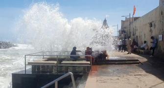
Churning the Arabian Sea, Cyclone Biparjoy on Wednesday was set to re-curve towards Gujarat's Kutch area and adjoining south Pakistan, slightly weakening in the process but still threatening to swamp the region with storm surges, strong winds and heavy rains.

Since its formation on June 6 in the southeast Arabian Sea, Biparjoy had maintained a northward track, gathering strength and becoming an extremely severe cyclonic storm on June 11, packing wind speed of more than 160 kmph, and then losing intensity a day later.
Addressing a press conference in New Delhi, India Meteorological Department Director General Mrutyunjay Mohapatra said Biparjoy was set to change path on Wednesday and begin moving north-eastwards towards Kutch and Saurashtra and have a landfall on Thursday evening near Jakhau Port.
"For the past six hours, it has become very slow, practically stationary. This is an indication that the direction of the movement of the cyclone will change now. We are expecting that it will move towards the northeast and it will hit Saurashtra, Kutch and adjoining Pakistan between Mandvi and Karachi near to Jakhau Port," he told reporters Wednesday afternoon.
"If you look at the intensity, cyclone Biparjoy has slightly weakened further. But, it will still have landfall as a very severe cyclonic storm with wind speed ranging from 125-135 kmph, gusting to 145 kmph from morning to evening on Thursday," Mohapatra said.
Under the influence of the cyclone, the low-lying areas of Saurashtra and Kutch are likely to witness storm surges of 2-3 metres above the astronomical tide during landfall and inundating the region.
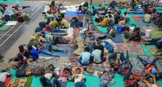
The weather office has asked authorities to restrict movement of tourists in popular sites such as Gir, Somnath and Dwarka and urged people to stay in safe spaces.
Parts of south Rajasthan and west Madhya Pradesh are expected to get rains and the possibility of development of thunder squalls in some regions may not be ruled out, Mohapatra said.
The strong winds are expected to cause total destruction of thatched houses, extensive damage to kutcha houses and some damage to pucca houses.