
The Met Department has predicted light to moderate rainfall across parts of West Bengal, Andhra Pradesh and Odisha with the probability of the severe cyclonic storm 'Asani' recurving.

LIVE! Incessant rains: Red Alert in 5 Kerala districts

Rains will continue to batter Tamil Nadu for the next seven days and the next 48 hours are "very crucial", the IMD has said.

Auto mobile retail sales in India witnessed a 10 per cent annual growth in July driven by robust sales across passenger vehicles, two-wheelers and commercial vehicles, industry body FADA said on Monday. Total retail sales across segments rose to 17,70,181 units last month, as compared to 16,09,217 units in July 2022. Passenger vehicle sales saw an increase of 4 per cent to 284,064 units last month, as compared to 273,055 units in the year-ago period, the Federation of Automobile Dealers Associations (FADA) said in a statement.

After lagging behind other segments in the automotive (auto) space over the past few years, two-wheelers are expected to reverse their volume underperformance. After witnessing a 36.3 per cent volume decline over the 2018-19 (FY19) through 2021-22 (FY22) periods, the sector staged a recovery in 2022-23 (FY23), with volumes rising 17 per cent. While volumes are still a quarter lower than the FY19 peak of 21 million units, a double-digit growth trajectory is expected to prolong.

Incessant showers lashed Mumbai and its neighbouring areas on Wednesday morning, leading to flooding in many low-lying areas and traffic snarls on roads, officials said.

The India Meteorological Department has issued a 'Red Alert' and predicted 'very heavy' to 'extremely heavy' rainfall across several districts of Assam till Thursday.
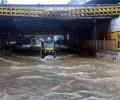
The India Meteorological Department (IMD) has forecast heavy rainfall in Mumbai and suburbs with very heavy to extremely heavy rains very likely at isolated places.

The India Meteorological Department (IMD) predicted that cold wave to severe cold wave conditions are very likely to continue in northwest India over the next three days and abate thereafter.
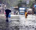
Some low-lying places like Hindmata, and areas in Dadar and Sion, including the Gandhi Market and road number 24 in Sion, were inundated, forcing pedestrians to wade through the water and making it difficult for motorists to commute.

A total of 33 teams have been earmarked by the National Disaster Response Force (NDRF) to undertake relief and rescue operations in Gujarat and Maharashtra ahead of the expected landfall of cyclone 'Biparjoy' near the Jakhau port in Kutch district, officials said on Wednesday.

The poisonous haze has been causing significant problems for people with existing respiratory issues, according to doctors.

The mercury breached the 46-degree Celsius mark in several places such as Allahabad (46.8 degrees Celsius) and Jhansi (46.2 degrees Celsius) in Uttar Pradesh; Sports Complex (46.4 degrees Celsius) in Delhi; Ganganagar (46.4 degrees Celsius) in Rajasthan; Nowgong (46.2 degrees Celsius) in Madhya Pradesh; and Maharashtra's Chandrapur (46.4 degrees Celsius).

An unspecified number of people were evacuated from coastal areas of Odisha where Jagatsinghpur, Kendrapara, Bhadrak and Balasore were likely to experience heavy rainfall accompanied by high-velocity winds, particularly on May 19 and 20, IMD Director General Mrutyunjay Mohapatra said.

A blinding layer of dense fog over north India, including Delhi, caused major inconvenience to commuters. The visibility levels were 50 metres around 5:30 am.
It's still early days, but the southwest monsoon has been nearly 37 per cent 'below normal' in the first seven days (June 1-7) of this month. According to the data furnished by the India Meteorological Department (IMD), between June 1 and June 7, India received 14.5 millimetres (mm) of rainfall, against a 'normal' 23.1 mm. Among places where rains have arrived, monsoon in Kerala in the first seven days has been 48 per cent 'below normal', while in Puducherry, it has been 56 per cent 'above normal'. In Tamil Nadu, rains were 21 per cent 'above normal' between June 1 and June 7.

Dense to very dense fog prevailed in some parts of the National Capital Region (NCR), Haryana, Punjab, west Uttar Pradesh and north Rajasthan on Tuesday.

Temperatures in March will be critical to determining the impact of any unusual heatwave conditions on this year's wheat crop in North India. It is that time of the year when the crop enters its vital grain-filling stage, say meteorologists and crop experts. So far, the high day temperatures in the North are not believed to have any significant impact on the final yields since the crop hasn't entered a stage where heat affects yields.

IMD issued red alerts for Thiruvananthapuram, Kollam, Pathanamthitta, Alappuzha, Kottayam, Ernakulam and Idukki districts.

The mercury at the Safdarjung Observatory is expected to breach the 43-degree mark on Thursday and touch 44 degrees Celsius by Friday, according to the India meteorological department.

Around 29 trains have been delayed by two to five hours due to foggy weather, a railway official said.

Delhi saw seven cold wave days in January 2020, while it did not record any such day last year.

Apart from 15 teams of the National Disaster Response Force (NDRF) and 12 teams of State Disaster Response Force (SDRF), personnel of the Army, Navy, Air Force, Indian Coast Guard and Border Security Force (BSF) are deployed for relief and rescue operations, officials said.

Very dense fog lowered visibility to 50 metres at the Palam observatory, near the Indira Gandhi International airport, at 5:30 am.

The orange alert has been issued for moderate or heavy thunderstorms and wind speed with 30-40 km per hour to reach some districts of Odisha within the next three hours.

The WR is taking various measures including setting up disaster management rooms, help desks, and keeping relief trains ready.

The city recorded a minimum temperature of 14.6 degrees Celsius, a notch above normal, according to the India Meteorological Department.

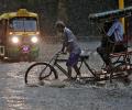
The city has been witnessing heavy rains since Tuesday night, resulting in water logging in many areas.

Heavy rains in Bengaluru on Wednesday night resulted in waterlogging, incidents of tree fall, damage to certain infrastructure and power outage in several parts.

The very severe cyclonic storm Tauktae could cause heavy to very heavy rains at isolated places in north Konkan, Mumbai, Thane and Palghar in Maharashtra on May 17, the India Meteorological Department (IMD) said.

The health minister said the Centre has taken timely measures ahead of the summer season to address heatwave-related illnesses.

Delhi's primary weather station, the Safdarjung Observatory, registered a maximum temperature of 40.4 degrees Celsius, four notches higher than normal.
Incessant rains unleashed more death and destruction on Monday in parts of north India, with 37 people killed in landslides and other rain-related incidents in the last two days even as the Army and NDRF teams stepped in to intensify the relief and rescue operations.

The Northern Railways said it has cancelled around 17 trains and diverted around 12 others, while traffic has been suspended at four locations due to waterlogging.

It was a repeat of scenes witnessed last month as motorists struggled to manoeuvre their vehicles on flooded roads and subways while showers led to traffic congestion in Chennai and suburbs.

The IMD also issued a red alert in the same 10 districts for August 3 also.

The city also recorded a maximum temperature of 23.8 degrees Celsius, 16 notches below normal and the lowest in the month of May since 1951, the IMD said.

A tormenting heatwave swept through North India on Sunday with the mercury crossing 49 degrees Celsius in pockets of Delhi, while the weather office forecast some relief Monday onwards.

The Safdarjung Observatory, which provides representative data for the city, recorded a maximum temperature of 40.1 degrees Celsius, which was eight notches more than normal, said Kuldeep Srivastava, the head of the IMD's regional forecasting centre.

'There's also a possibility of the cyclonic system changing its course, thus avoiding a landfall in Odisha'