
Above-normal cold wave days are expected in some areas of central India, eastern Uttar Pradesh and Bihar during January 2026.

A severe cold wave has intensified across North India, with Delhi recording its lowest temperature of the season. Rajasthan experienced sub-zero temperatures, and several states have issued alerts and closed schools due to the extreme conditions.

The winters could be cooler in the plains due to the prevailing La Nina conditions though it does not have a direct relationship and also due to influence of the polar vortex.

Sonia Gandhi criticizes the Modi government's environmental policies, claiming they endanger the Aravalli hills and disregard environmental protection.
The India Meteorological Department (IMD) has predicted above-normal rainfall for most parts of India during the post-monsoon season (October to December), except for some areas in the northwest. The southwest monsoon season ended with the country recording eight per cent above normal rainfall.

The India Meteorological Department (IMD) forecasts the withdrawal of the southwest monsoon from northwest India around September 15. This year's monsoon covered the country earlier than usual, resulting in surplus rainfall and extreme weather events.
The India Meteorological Department (IMD) forecasts above-normal rainfall for India in September, following a monsoon season marked by heavy downpours and related disasters in various regions. The forecast indicates normal to above-normal rainfall for most areas, with some exceptions in the northeast, east, extreme south peninsular India, and parts of northwest India.

The record monsoon rains across India during the June to September months was 937.2 millimetres, the 5th-highest since 2001 and 38th-highest since 1901.

The rains after arriving over Kerala will quickly cover Tamil Nadu and Karnataka, but then might slacken a bit, which could delay its arrival over Northwest India.

Heatwave may abate over most parts of North India in next two days; temperatures likely to drop by 2-3C.

Hydrology experts suggest that India cannot be directly blamed for the devastating monsoon flooding in Pakistan this year, citing greater destruction upstream of the border and lack of evidence for intentional action.
The India meteorological department said heatwave conditions will persist for at least two more days.

The Met office has issued a "red" warning for Delhi, Haryana, Punjab and west Rajasthan, stressing the need for "extreme care for vulnerable people".

The India Meteorological Department (IMD) has predicted above-normal rainfall across India in June, with most parts of the country likely to experience normal to below-normal maximum temperatures. The IMD also anticipates above-normal minimum temperatures across most of the country, except for some parts of central India and the adjoining south peninsula. The southwest monsoon reached Kerala on May 24, marking its earliest arrival over the Indian mainland since 2009. The monsoon is crucial for India's agriculture-dependent economy, providing vital water for crops and supporting drinking water and hydropower generation.

Temperatures are likely to remain in a similar range until Thursday, with a gradual fall expected from June 13.
The southwest monsoon arrived in Maharashtra on Sunday, making it the earliest onset of the annual rainfall season over the state in 35 years, according to the India Meteorological Department. The monsoon is expected to advance to Mumbai and some other parts over the next three days. The monsoon advanced into some more parts of the Arabian Sea, Karnataka, entire Goa, parts of Maharashtra, north Bay of Bengal, and parts of Mizoram, parts of Manipur and Nagaland on Sunday. The northern limit of monsoon passes through Devgad, Belagavi, Haveri, Mandya, Dharmapuri, Chennai, Aizawl and Kohima. Conditions are favorable for further advance into some more parts of central Arabian Sea, more parts of Maharashtra including Mumbai, Karnataka including Bengaluru, some parts of Andhra Pradesh, remaining parts of Tamil Nadu, more parts of west-central and North Bay of Bengal and some more parts of North Eastern states during next three days. The southwest monsoon hit Kerala on Saturday, marking its earliest arrival over the Indian mainland since 2009.

The southwest monsoon has arrived in Mumbai 16 days before its usual date, making it the earliest arrival since 1950. This early onset follows the monsoon's arrival in Kerala, the southernmost state, on Saturday, marking the earliest arrival since 2009. The India Meteorological Department (IMD) predicts an above-normal rainfall for the 2025 monsoon season, with rainfall between 96 per cent and 104 per cent of the 50-year average of 87 cm considered 'normal'. The monsoon is crucial for India's economy, providing vital water for agriculture and replenishing reservoirs.
The early onset of the southwest monsoon brought continuous rainfall across southern and eastern India, contributing to this record.

The labourers, who are said to be of Nepali origin, were engaged in the construction of a hotel.
In Rajasthan, Pilani recorded 44.9 degrees Celsius, Phalodi and Churu touched 43.8 degrees Celsius and 43.5 degrees Celsius respectively, while Bikaner and Jaipur registered 43.4 degrees Celsius and 43 degrees Celsius.
India is expected to experience hotter-than-usual temperatures from April to June, with more heatwave days in central and eastern India and the northwestern plains, the IMD said. Most parts of the country will see higher-than-normal maximum temperatures, except for some areas in western and eastern India where the temperatures are expected to be normal. Minimum temperatures will also be above normal in most regions. The IMD has warned that landslides could occur in parts of Kerala and Karnataka in the Western Ghats and that northeastern states might face flooding in April.

Wheat production during the current season is expected to be better than last year provided the weather remains favourable over the next few weeks, said senior industry executives. The weather had turned uncharacteristically hot in the latter half of last month, but owing to strong winds, the chill has returned in the last few days.
The IMD said India did not experience any "break monsoon" conditions this year because of the large number of low-pressure systems.

States are mandated to develop and implement 'heat HAPs' for prevention of heat-induced diseases. But most do not go beyond standard advisory on heat prevention.
'The intensity and frequency of heatwaves will be much higher than in previous years over Punjab, Haryana, Rajasthan, Gujarat, Madhya Pradesh and Odisha.'

A cold wave has intensified in most parts of north India, with temperatures in the Kashmir Valley dipping below freezing point. The national capital saw a brief respite from the bitter cold during the day, but cold conditions persisted in parts of Rajasthan and Himachal Pradesh. The weather department has issued a yellow warning for cold wave, ground frost and dense fog for some places in Himachal Pradesh. There is a possibility of rain and snowfall in parts of northwest India later in the week.

Heavy rain in the first week of July compensated for the shortfall but caused flooding in many northeastern states.

India recorded around 16 per cent more rainfall than normal in August, with rainfall over Northwest India recorded at 253.9 mm, the second highest in August since 2001, the India Meteorological Department (IMD) said on Saturday.

June rainfall accounts for 15 percent of the total precipitation of 87 cm recorded during the four-month monsoon season in the country.

Temperatures in 17 locations breached 48 degrees Celsius on Monday, with the relentless heat affecting health and livelihoods across large parts of northwestern and central India.

The IMD said that rainfall over India in August and September would be around 106 percent of the long-period average of 422.8 mm.
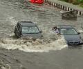
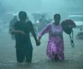
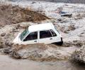
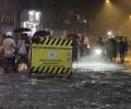
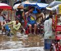
At least 28 people died in rain-related incidents Sunday as heavy downpours lashed north and northwest India, causing landslides, traffic chaos and house collapses, as well as a dam breach which inundated several villages in Haryana.

The weather office said intensity of heat wave/severe heat wave has slightly reduced over some parts of northwest and adjoining central India.

Heatwave conditions are expected over northwest India during the next five days, with Punjab, Haryana, Rajasthan and Delhi predicted to bear the maximum impact, the India Meteorological Department (IMD) said on Thursday.

India has received 20 per cent less rainfall since the start of the monsoon period on June 1, with the rain-bearing system making no significant progress between June 12 and 18, according to the India Meteorological Department (IMD).

'Usually the average rainfall per day is around 8 mm and India is receiving 10 to 11 mm per day since the last one week.' 'July seems to be very good for the entire country.'

After churning across the Arabian Sea for more than 10 days, Biparjoy made landfall near Jakhau Port in Gujarat on Thursday.

'Dense' to 'very dense' fog prevailed in parts of Punjab, Haryana, west Rajasthan, Bihar, Delhi, west Uttar Pradesh, Jharkhand, Odisha and Assam.

Hailstorms were reported at various parts of the national capital including Palam, Chilpighat and Ayanagar, the IMD said.

Satellite imagery showed a dense elongated band of fog stretching from Punjab to the northeast.