NISAR will not be used for surveillance and will be used to observe the earth.

The Indian space agency is gearing up for the July launch of the NISAR (NASA-ISRO Synthetic Aperture Radar) satellite, a joint initiative of India and the US.
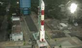
The Indian rocket Geosynchronous Satellite Launch Vehicle (GSLV) code-named GSLV-F16 will orbit NISAR sometime in July.
The Indian Space Research Organisation began the launch campaign activities at Sriharikota in the first week of April.

After the completion of works related to NISAR at ISRO's Satellite Integration and Testing Establishment located in Bengaluru, the US space agency National Aeronautics and Space Administration (NASA) had said the two countries are reviewing the launch date.
The NISAR launch has been changed a couple of times owing to various reasons.
ISRO had earlier said the NISAR satellite will be launched in 2022 or early 2023.
That apart, the NISAR launch was expected to happen on June 18. However it got delayed again.
Senior ISRO scientists including Chairman Dr V Narayanan are in the US in connection with the Axiom Mission 4 on which an Indian astronaut will travel to the International Space Station.
The Ax-4 mission was delayed due to an liquid oxygen leak in the Falcon 9 rocket's booster which needed to be plugged.
It was on September 30, 2014 that the two space agencies signed an equal partnership to collaborate and launch NISAR.

NISAR is a first-of-a-kind dual-band radar satellite that will measure land deformation from earthquakes, landslides, and volcanoes, producing data for science and disaster response.
It will track how much glaciers and ice sheets are advancing or retreating and it will monitor growth and loss of forests and wetlands for insights on the global carbon cycle.
Twice every 12 days, the NISAR satellite will scan nearly all of Earth's land and ice surfaces to measure changes in the planet's ecosystems, growth and retreat of its land and sea ice, and deformation of its crust.
The data gathered will assist in tasks as infrastructure monitoring, disaster response, biomass assessment, and agricultural management.

ISRO identified science and applications that were complementary to the primary mission objectives: Agricultural monitoring and characteriSation, landslide studies, Himalayan glacier studies, soil moisture, coastal processes, coastal winds, and monitoring hazards.
Though NISAR has the SAR (synthetic aperture radar), a former ISRO chairman earlier said NISAR will not be used for surveillance and will be used for earth observation.
Under this collaborative project, NASA is responsible for providing the L-Band SAR payload system and the Indian agency will supply S-Band SAR payload.
Both the SAR systems will make use of a large size (about 12m diameter) common unfurlable reflector antenna.
That apart, NASA also provides engineering payloads, including a Payload Data Subsystem, High-rate Science Downlink System, GPS receivers and a Solid State Recorder.
The spacecraft bus, the S-band radar, launch vehicle and associated launch services are provided by ISRO.

NISAR will be the first Earth-observing satellite with two kinds of radar -- an L-band system with a 10-inch (25-centimeter) wavelength and an S-band system with a 4-inch (10-centimeter) wavelength.
Whether microwaves reflect or penetrate an object depends on their wavelength.
Shorter wavelengths are more sensitive to smaller objects such as leaves and rough surfaces, whereas longer wavelengths are more reactive with larger structures like boulders and tree trunks.
So NISAR's two radar signals will react differently to some features on Earth's surface.
By taking advantage of what each signal is or isn't sensitive to, researchers can study a broader range of features than they could with either radar on its own, observing the same features with different wavelengths.

The NISAR observatory carries a 12m wide deployable mesh reflector mounted onto a deployable 9m boom developed by NASA's Jet Propulsion Laboratory (JPL) which shall be used by both-JPL-NASA developed L-Band SAR payload system and ISRO developed S-Band SAR payload.
After the successful in-orbit checkout of the satellite, the science operations phase will start and extend for three years and contain all data collection required to achieve the L1 science objectives.
During this phase, the science orbit will be maintained via regular maneuvers, scheduled to avoid or minimise conflicts with science observations.
Extensive calibration and validation activities will take place throughout the first five months, with yearly updates of 1-month duration.


Venkatachari Jagannathan can be reached at venkatacharijagannathan@gmail.com