
The cyclonic storm is likely to move nearly westwards and cross north Andhra Pradesh-south Odisha coasts between Kalingapatnam and Gopalpur around Sunday evening, the Cyclone Warning Division of the IMD said.

The Met Department has predicted light to moderate rainfall across parts of West Bengal, Andhra Pradesh and Odisha with the probability of the severe cyclonic storm 'Asani' recurving.

Severe cyclonic storm Michaung crossed south Andhra Pradesh coast close to Bapatla district between 12.30 pm and 2.30 pm on Tuesday with maximum gales of up to 90-100 km per hour speed, said an Amaravati Meteorological Centre official.

'There's also a possibility of the cyclonic system changing its course, thus avoiding a landfall in Odisha'

The system lay centered at 5.30 am over Southeast Bay of Bengal, about 450 km west-northwest of Car Nicobar (Nicobar Islands), 380 km west of Port Blair (Andaman Islands), 970 km southeast of Visakhapatnam (Andhra Pradesh) and 1030 km south-southeast of Puri (Odisha).

Prime Minister Narendra Modi on Thursday reviewed the preparedness to deal with the situation arising out of the likely formation of Cyclone Jawad that is expected to hit the North Andhra Pradesh-Odisha coast and directed officials to take every possible measure to ensure that people are safely evacuated.

The southwest monsoon might finally start withdrawing from parts of North-West India over the next three days, signaling the end of its four-month journey over the country that started in June, the India Meteorological Department (IMD) said. However, though the retreat might begin from next week, the rains might not descend quickly, as the met department predicted fresh spells of rains in Vidarbha, Chhattisgarh and east MP on September 21-22 and over Odisha, Coastal areas north Andhra Pradesh and Gangetic West Bengal on September 19-21. "Due to anti-cyclonic flows over northwest India at lower tropospheric levels, dry weather is very likely over west Rajasthan, Punjab, Haryana, Chandigarh and Delhi during the next five days. "Hence conditions are becoming favourable for the withdrawal of Southwest Monsoon from parts of northwest India during next three days," the IMD said.

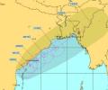
'It is very likely to move nearly northwards for next few hour and recurve slowly north-northeastwards along Narsapur, Yanam, Kakinada, Tuni and Visakhapatnam coasts during noon to evening on Wednesday and emerge into west central Bay of Bengal off North Andhra Pradesh coasts by night,' the India Meteorological Department said in its national bulletin.

The cyclone expected to weaken gradually over the next two days.

Cyclone 'Phailin', which was to make landfall two days from now, possibly near Gopalpur in Odisha and in north Andhra Pradesh, on Thursday intensified into a severe cyclonic storm travelling slightly northwest and lying about 800 km from Paradip in Odisha.

The depression, which was initially over west-central Bay of Bengal and adjoining areas, moved westward and intensified into a deep depression.

Cyclonic storm Hudhud will turn take a 'very severe' turn in the next 12 hours, bringing with itself very heavy rainfall and gusty winds as it inches closer to the coast, the MeT department has said.

The orange alert has been issued for moderate or heavy thunderstorms and wind speed with 30-40 km per hour to reach some districts of Odisha within the next three hours.

Cyclone Hudhud has moved closer to the cost of Odisha and Andhra Pradesh and will turn into a severe cyclonic storm in next 12 hours, the India Meteorological Department said.

A Yuvajana Shramika Rythu Congress Party activist was on Wednesday arrested for allegedly posting 'irresponsible' comments on the social networking site Facebook regarding cyclone Hudhud which hit the North Andhra Pradesh coast earlier this month.

As many as 57 villages were marooned and 60 mandals were affected. As many as 33,570 families were affected out of whom 9,257 families were evacuated and lodged in 31 relief camps.

Heavy falls at isolated places are very likely over Kerala on April 29 and 30. The system will not make landfall in Tamil Nadu, but may bring light rain in some northern parts, it said.
The strong wind that is expected may cause damage to thatched houses, uproot trees and disrupt power supply and communication network in coastal Orissa and neighbouring AP.
The IMD has warned of squally winds speed reaching 45-55 kmph gusting to 65 kmph likely to commence along and off Odisha and north coastal Andhra Pradesh coasts from October 27 onwards.
Heavy rainfall coupled with gusty surface wind is likely to pound some parts of Odisha as the deep depression over west-central Bay of Bengal intensified into a cyclonic storm 'ROANU' on Thursday.

Exactly a year after the very severe cyclonic storm Phailin struck the state, another storm is heading towards the Odisha coast.

The India Meteorological Department said rainfall would be accompanied by gale wind speed reaching 140 to 150 kmph and gusting to 165 kmph along and off Odisha and north Andhra Pradesh coasts.
The deep depression in North Andaman Sea and its neighbourhood intensified into a cyclonic storm on Wednesday and is likely to cross Andhra Pradesh and Odisha coast on October 12.

The metrological department on Saturday said that Phailin is a very severe 'super cyclone' and its wind speed may go up to 200 and 240 km per hour by noon itself.

As Cyclone Hudhud is closing in on the Andhra Pradesh coastline and is expected to make a landfall near Visakhapatnam by Sunday afternoon, about 1.11 lakh people in five coastal districts have been shifted to safer places.