
Taken from the Indian Remote Sensing Satellite hovering over space, the image shared by ISRO on Sunday shows the grand new temple which will be inaugurated on January 22.
The deadly landslides in Kerala's ecologically fragile Wayanad district were triggered by a heavy burst of rainfall, made 10 per cent heavier by climate change, according to a new rapid attribution study by a global team of scientists.

The subsidence zone is located at central Joshimath only including the Army Helipad and Narsingh temple, the satellite images revealed.
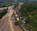
A GLOF occurred in parts of Lhonak Lake, leading to a rapid rise in water levels with very high velocities downstream along the Teesta River Basin in the early hours of October 4. This resulted in severe damage in Mangan, Gangtok, Pakyong and Namchi districts.

Scientists at ISRO used the orbiter high resolution camera onboard the Chandrayaan-2 orbiter to study the lunar surface hours before and after the soft-landing of Vikram lander on the moon on August 23.

The statements on Joshimath are creating confusion not only among affected residents but also among citizens of the country.

A study by an international team of researchers had warned two year ago that the South Lhonak lake in Sikkim may burst in the future and significantly impact the downstream region.
'There were literally thousands of houses with cracks.' '40 percent of the town has been affected.'
According to experts, slopes in Himachal have become highly vulnerable to landslides due to cutting of rocks at the foothills and the lack of proper drainage system, and high intensity rainfall is making the things worse for the state.

The local administration has set up relief centres at four-five places in the Himalayan town, Garhwal commissioner Sushil Kumar said.

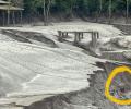
The NRSC satellite imagery revealed that the lake covered approximately 162.7 hectares. Its area increased to 167.4 hectares on September 28 but drastically reduced to 60.3 hectares.

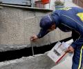
The PSInSAR satellite technique used to observe the gradual sinking of Uttarakhand's Joshimath town is a powerful remote sensing tool capable of measuring and monitoring displacements in the Earth's surface over time.

States have been told to prepare in advance to counter any impact of an adverse southwest monsoon.

Talking to PTI, he said the development works should be implemented by protecting the lives of the people.

The first images clicked by the manned aircraft of the Indian Space Research Organisation, sent earlier on Wednesday to find traces of the missing Chief Minister of Andhra Pradesh Y S Rajashekhar Reddy in the Nallamalla forests, have been received and are being analysed by the National Remote Sensing Centre in Hyderabad, according to sources in ISRO.

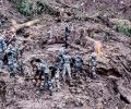
Officials said 13 more families living in houses with huge cracks were moved by the administration to safe locations on Sunday.

The city houses National Remote Sensing Centre and is also home to several companies offer geographical information system services.

A US court has asked Antrix Corporation, the commercial arm of Indian Space Research Organisation, to pay a compensation of USD 1.2 billion to a Bengaluru-based startup, Devas Multimedia, for cancelling a satellite deal in 2005.

Naval submarine INS Sindhudhvaj has begun underwater search along the Tamil Nadu coastline to trace the missing Coast Guard Dornier aircraft.

The threshold limit for deduction of tax at source has been raised for unusual income such as winnings from horse race, commission

The Sikkim government is planning to convert an artificial lake, formed by a massive landslide in the state's northern part in August last year, into a tourist spot.

Prime Minister Narendra Modi is likely to urge Tim Cook to begin manufacturing its prized iPhones in India.