Though General Naravane's visit will not deal with 'impermanent' issues like the changing stands of politicians, it will certainly reinforce the deeper 'permanent' links between the people of Nepal and India.
Time will hopefully tackle the present impermanence of the Sino-Nepalese romance, notes Claude Arpi.

More than 2,500 years ago, Gautam Buddha preached that everything is impermanent. Though the Great Son of India and Nepal probably did not have this in mind, it is particularly true with regard to the political regimes around the world.
It is important to remember this deep truth as relations between Nepal and India are going through a tough patch, mainly due to some Maoist leaders's reckless actions and their newly found love for China (and its pretty ambassador in Kathmandu).
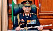
Moreover, there is something more permanent in the India-Nepal relationship, it is an ancient kinship, a deep cultural, religious and economic closeness and it is this that General Manoj Mukund Naravane, the army chief, will be dealing with on his three-day visit to Nepal where he will be conferred the rank of honorary general of the Nepali army.
The border issue
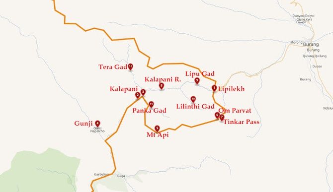
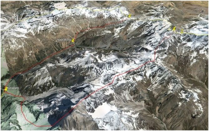
Though the border dispute will certainly not be discussed during the COAS's trip to Kathmandu, it is worth examining some of its aspects over the Kalapani area.
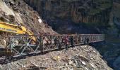
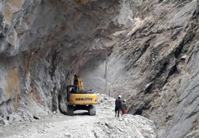
On May 8, 2020, an argument erupted between India and Nepal; the immediate reason which triggered the debate was an 80 km road between Darchula to Lipulekh, the border pass near the trijunction with Tibet and Nepal, inaugurated by Defence Minister Rajnath Singh.
The road is to be used by Indian pilgrims visiting Kailash-Mansarovar, located some 90 km from the pass, as well as local traders. Lipulekh is one of the three landports between India and China. Strategically, this road is also crucial for India.
Kathmandu handed over a diplomatic note protesting against the construction of the road to Vinaya Mohan Kwatra, the Indian Ambassador to Nepal; Kwatra was subsequently called by Pradeep Kumar Gyawali, Nepal's foreign minister, who lodged a protest.
It is only very late that the Nepalis realised that there was a dispute.

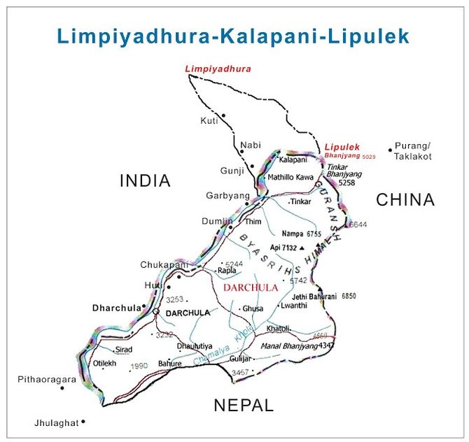
In 1998, the Communist Party of Nepal (Marxist-Leninist) faction led by Bam Dev Gautam started claiming some Indian territory in the vicinity of Kalapani as being Nepalese; one of the main actors was Buddhi Narayan Shrestha, the former director general of the Land Survey Department.
According to him, the 'Kali River' was in fact the Kuthi Yankti river that arises below the Limpiyadhura range and not the one earlier accepted by India, China and Nepal.
For the first time on May 20, 2020, Nepal released a map incorporating the Maoist claims; it showed the entire area to the east of Kuthi Yankti river as part of their territory.
To make it worse, on June 13, a bill seeking to give legal status to the new map was unanimously approved by the Lower House in the Nepal Parliament.
Tracing the History
After a War between British India and Nepal in 1814, the Nepalis were sent back across the Kali river in May 1815 and subsequently the Segowli Treaty was signed on March 4, 1816.
Article 5 of the Treaty stated: 'The Rajah of Nepaul renounces for himself, his heirs and successors, all claim to or connexion with the countries lying to the West of the River Kali, and engages never to have any concern with those countries or the inhabitants thereof.'
Unfortunately, there was no map attached which could have authoritatively shown the exact alignment and the source of the Kali river.
At that time, no scientific survey worth the name could be carried out; it was only by mid-19th century that the Himalayan border was first surveyed in a more scientific manner by the Great Trigonometrical Survey of India (a precursor of the Survey of India).

General Conwan's Take
General Sam Cowan, a retired British general, who studied Nepal through his British Gurkha connections, wrote in 2015 a well-researched article; though there is no doubt that Conwan's sympathies lie with Nepal, his arguments are interesting nevertheless.
Long before the issue of Kalapani erupted, he observed: 'A further major complication for Nepal is that India rejects the claim that the river from Lipu Lekh is the renamed Kali river. It asserts, and claims that it has maps and diagrams to prove it, presumably based on the 1879 map, that the river Kali begins from the junction of the river that flows from Lipu Lekh and a stream that flows from springs in Kalapani.'
'Hence, the earlier quote from the Indian pilgrim that "Kalapani... is supposed to be the origin of river Kali".'
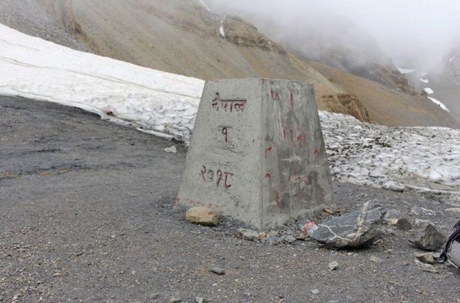
However Conwan can only admit: 'Nepal's case for Kalapani has been badly undermined by long years of silence on the issue by the country's leaders... However, for the present, the reality is that the India-Nepal-China tri-junction is de facto just to the west of Border Pillar Number 1.'
The Border in the 1950s
Already in the early 1950s, the local police already manned a check-post at Kalapani. In his diary, Lakshman Singh Jangpangi, the Indian trade agent in Gartok wrote: 'July 10, 1955. I started and camped at Kalapani near Police Post. A section of P.A.C. [Provincial Armed Constabulary] under Subedar Sher Singh has been stationed here since 28th June 1955.'
'This post is about 8 miles below the pass and a patrol party occasionally goes up to the pass. There is plentiful supply of firewood and water here.'
'They are living in two single-fly tents and Subedar has constructed a small mud hut for himself which leaks very badly in rainy weather.'
'The Garbyang villagers have cultivated land close to the post. Besides passing caravans they have no other company or activities. I saw them keeping busy in collecting firewood and making Subedar's hut livable.'
The police post had probably been set up in 1952 by the Uttar Pradesh government.
The 1961 Sino-Nepal Treaty
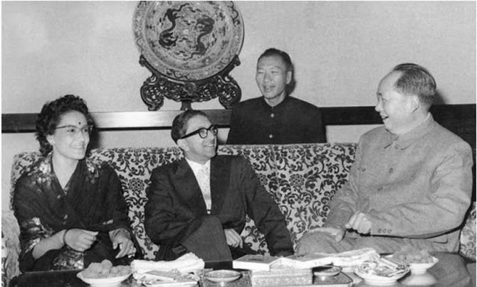
While China is today instigating some political leaders to pick up a fight with India, the 'Boundary Treaty between the People's Republic of China and the Kingdom of Nepal' signed by then Chinese president Liu Shaoqi and Nepal's then king Mahendra on October 5, 1961, shows the Kali river as per the Indian stand.
Article I (1) defined the China-Nepal boundary line which 'starts from the point where the watershed between the Kali river and the Tinkar river meets the watershed between the tributaries of the Mapchu (Karnali) river on the one hand and the Tinkar river on the other hand...'
Kathmandu seems to have forgotten that the location of the river on the maps of the Sino-Nepal treaty matches with the Indian one, which implies that the new road is on Indian territory.
What presently compounds the issue is the rift within the ruling party's leadership in Nepal and the role played by China through Hou Yanqi, Beijing's ambassador to Kathmandu, the new 'queen' of Nepal, who has been constantly interfering at the top level of the ruling Nepal Communist Party.
Mao's Blessings
In a recent article entitled 'Nepal-China Boundary Treaty: An example of peaceful Himalayan frontiers', a Nepali author, Birat Anupam, quoted a discussion between Mao Zedong and King Mahendra which took place after the signature of the 'historic' Nepal-China Border Treaty.
Mao told the king: 'It is good that we agree. There is goodwill on both sides. We hope that will get along well, and you hope we shall get along well too. We do not want to harm you nor do you want to harm us.'
It shows that the 1961 treaty had the blessings of the Great Helmsman... and the first of the 79 pillars coincides with India's stand on the dispute.
During subsequent visit of Nepali leaders to China, the trijunction was confirmed and tallied the Indian position.
On November 21, 1979, the China-Nepal border protocol was signed.
In reply to a question about the Nepal-China boundary, Huang Hua, the then Chinese premier, observed: 'The boundary question was settled long ago. But now the joint boundary inspection committee had perfected the understanding of the line so that it is the more accurate basis.'
Hua added: 'Protocol is a significant document achieving accurate demarcation of the boundary line between Nepal and China.'
It is a fact that the border has been the traditional frontier for decades and it has never been objected to by China or Nepal.
Other proof in favour of India's stand
The Memorandum between the Government of the Republic of India and the Government of the People's Republic of China on the Resumption of Border Trade signed on 13 December 1991, and Protocol on Entry and Exit Procedures for Border Trade, signed on July 1, 1992 are other example confirming that China agreed to the border in this area.
The Trade Protocol between the two countries provided for expansion and diversification of trade between the two countries.
It was the first time that a pass reopened after the 1962 India-China war and the subsequent shutting down of the Himalayan borders. For China, the border pass was (and still is today) Lipulekh.
What is the Issue?
The river Kali does not seem to be the real issue, but the area south of the river perhaps is. Major General Vinaya Chandran, who is doing a PhD on Nepal and earlier served in the Indian Army's Military Operation Directorate, commented for stratnewsglobal: 'Even if both sides accept Lipulekh as the origin of the Kali river, they need to resolve the issue of the start point of the boundary, which now is on the highest point of the Eastern shoulder of Lipulekh Pass.'
'This is also the point from where the China-Nepal boundary starts. The India-Nepal boundary marked on Indian maps, run South from this point along the watershed and Joins the Kali river, South of Kalapani.'
'The boundary in effect is running along the watershed and not along the Kali river. This is an issue that needs to be resolved bilaterally by India and Nepal.'
There is no doubt about the location of the river and the fact that the new road is inside Indian territory; it is, however, in Delhi's interests to find an amicable solution with Nepal for the areas for which there is no agreement; it could avoid China poking its nose into the bilateral affairs between Delhi and Kathmandu in the future.
Though the army chief's visit will not deal with 'impermanent' issues such as the changing stands of politicians, it will certainly reinforce the deeper 'permanent' links between the people of Nepal and India.
Time will hopefully tackle the present impermanence of the Sino-Nepalese romance.
Claude Arpi is a long-time contributor to Rediff.com.
Feature Presentation: Rajesh Alva/Rediff.com