A rock mass weakened over a period of time due to freezing and thawing of snow must have led to the creation of a "weak zone", triggering its collapse, which resulted in the formation of a temporary dam that eventually breached, causing the deadly floods in Uttarakhand's Chamoli district on Sunday, initial observations by scientists of the Wadia Institute of Himalayan Geology suggest.

Kalachand Sain, Director of the WIHG, said the incident occurred adjacent to the Raunthi glacier.
The area also has glaciers that feed the Rishi Ganga river, which ultimately joins the Dhauli Ganga.
Sain said the avalanche must have taken place in the wee hours of Sunday while the temporary dam must have breached between 10-11 am.
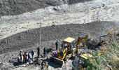
Two teams comprising five glaciologists of the WIHG are at the site conducting observations.
The teams carried out a helicopter survey of the area on Tuesday to find clues as to what led to the massive flash floods that swept everything on the way.
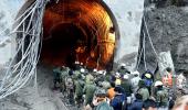
So far, the flash floods have claimed 32 lives.
"Our observations suggest that the rock mass may have weakened due to freezing and thawing over a period of time. This sometimes leads to the development of a weak zone and fractures," Sain said.
The area also witnessed precipitation in the preceding three days, followed by clear weather on the day of the event, which caused a freezing and thawing effect.
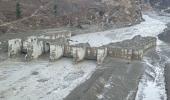
"The event occurred due to a slide of a large rock mass beneath the hanging glacier at 5,600 metres above sea level. It was observed that a huge rock and glacial ice masses collectively moved rapidly down the valley, taking away along with them all the snow and other loose material coming their way," Sain said.
The steep slopes of the mountains in the region further increased the intensity of the crash. The stretch of the avalanche was about three kilometres with an average slope of 37 degrees, before reaching the "Raunthi Nala/Gadhera" floor at an altitude of about 3,600 metres.
Thus, the rock-and-snow avalanche was able to entrain a vast amount of water and sediment.
"It seems that the materials blocked the water to the Raunthi Nala stream, causing a temporary water impoundment. The impounded water was eventually breached, which might have caused the catastrophic flash floods," Sain said.
An institute under the Department of Science and Technology, the WIHG studies the Himalayan environment and its geology. Sain said an initial report will be sent to the DST.