Geological factors apart, the failure of successive governments to act on the warnings by experts about possible hazards in Joshimath and adjoining areas has emerged as a major reason behind the land subsidence crisis that has now gripped the town, environmentalist Chandi Prasad Bhatt said on Monday.
![]()
Yet another effort has been made by the state government for a scientific study with the help of satellite imagery of the crisis in the sinking town, Bhatt, who is associated with the Chipko Movement, said.
However, a detailed zonation mapping of the Himalayas in Uttarakhand and Himachal Pradesh, warning of the lurking dangers in Joshimath, had been submitted to the state government more than two decades ago, he said.
The study carried out using remote sensing and Geographic Information System by around twelve leading scientific organisations of the country including the National Remote Sensing Agency had been submitted to the state government way back in 2001, he said.
The mapping of the area covering the entire Char Dham and Mansarovar yatra routes including Joshimath had also been submitted to the district administrations of Dehradun, Tehri, Uttarkashi, Pauri, Rudraprayag, Pithoragarh, Nainital and Chamoli at that time.
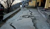
In this zonation mapping report 124.54 sq km area of Joshimath had been divided into six parts in accordance with their susceptibility to landslides, Bhatt said.
Over 99 per cent of the mapped area had been shown as landslide-prone in varying degrees, he said, adding 39 per cent of the area was identified as a high-risk zone, 28 per cent as a moderate-risk zone and 29 per cent as a low-risk zone and the rest in the lowest.
Subsequently, a daylong meeting was also held between senior administrative officials, experts, people's representatives and social workers in Dehradun over the study in which the district magistrates concerned had agreed to take the required safety measures in light of the study.
However, nothing was done and the state government had to face a lot of criticism for not acting on the study in the wake of the 2013 Kedarnath disaster -- the 'Himalayan tsunami' which killed more than four thousand people, Bhatt, a recipient of the Ramon Magsaysay, Padma Bhushan and Gandhi Peace award said.
"Failure of successive governments to act on expert warnings seems to be at the root of the Joshimath crisis," he said.
"One study after another would not help until the governments begin to act on what they were recommended", the nonagenarian on whose request to the state government, the then ISRO Chairman K Kasturirangan constituted a group of organisations headed by NRSA to do zonation mapping of the region.
Bhatt, who was part of various discussions held with the government on the vulnerability of the region to disasters as an advisor, said, "Once again the problem is being ignored in the name of conducting studies."
"The NRSA's landslide hazard zonation mapping submitted in 2001 and the 1976 report of the Mishra Committee of which I too was a part contain enough suggestions about the safety measures to be adopted to save towns like Joshimath and their residents," he said.
"What is needed is action, not just another study," Bhatt said.