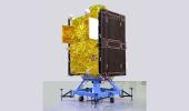
The main focus of the all weather RISAT-1B satellite will be to observe the Indian land with its C-band synthetic aperture radar.

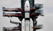
Beefing up its surveillance network in space, India will orbit one more spy in the sky -- the RISAT-1B or EOS-09, a radar imaging satellite -- on May 18 morning.
The RISAT-1B will be orbited by the Polar Satellite Launch Vehicle (PSLV-C61) XL variant.
While the 1,710 kg RISAT-1B will be the main payload, smaller satellites will piggyback on it.
The main focus of the all weather RISAT-1B satellite will be to observe the Indian land with its C-band synthetic aperture radar (SAR).
The satellite will be injected into the sun synchronous orbit at an altitude of about 529 km.
This will be the seventh RISAT series satellite launched by the Indian Space Research Organisation. The first RISAT satellite RISAT-2 was launched in 2009.
The other RISAT series satellites orbiting now are the RISAT-2, RISAT-1, RISAT-1A, RISAT-2B, RISAT-2BR1, RISAT-2BR2.
A former ISRO chairman said any satellite with a camera can be of dual use -- civilian and military.
Meanwhile, ISRO is also gearing up for another satellite launch with SAR in June.
ISRO will launch the NISAR (NASA-ISRO Synthetic Aperture Radar) satellite, a joint India-US initiative.
The Geosynchronous Satellite Launch Vehicle (GSLV) -- code-named GSLV-F16 -- will orbit NISAR sometime this June.
ISRO began the launch campaign activities at Sriharikota in the first week of April.
After the completion of work related to NISAR at ISRO's Satellite Integration and Testing Establishment in Bengaluru, the US National Aeronautics and Space Administration (NASA) had said the two countries are reviewing the launch date.
NISAR is a first-of-a-kind dual-band radar satellite that will measure land deformation from earthquakes, landslides, and volcanoes, producing data for science and disaster response.
Under this collaborative project, NASA is responsible for providing the L-Band SAR payload system and the Indian agency will supply S-Band SAR payload.
It will track how much glaciers and ice sheets are advancing or retreating and it will monitor growth and loss of forests and wetlands for insights on the global carbon cycle.
Twice every 12 days, the NISAR satellite will scan nearly all of earth's land and ice surfaces to measure changes in the planet's ecosystems, growth and retreat of its land and sea ice, and deformation of its crust.
The data gathered will assist in tasks as infrastructure monitoring, disaster response, biomass assessment, and agricultural management.
ISRO identified science and applications that were complementary to the primary mission objectives: Agricultural monitoring and characterisation, landslide studies, Himalayan glacier studies, soil moisture, coastal processes, coastal winds, and monitoring hazards.
Though NISAR has the SAR (synthetic aperture radar), a former ISRO chairman had earlier said NISAR will not be used for surveillance and will be used for earth observation.
Venkatachari Jagannathan can be reached at venkatacharijagannathan@gmail.com
Feature Presentation: Aslam Hunani/Rediff.com