'China could intentionally release excess water.'
'The North East is already flood-prone during the monsoon, and even a controlled release from Chinese dams (during the monsoon) could worsen flooding.'

While Pakistan promotes a narrative of China weaponising the Brahmaputra against India, mirroring India's leverage over the Indus, the hydrological realities tell a different story.
Unlike the Indus, the majority of the Brahmaputra's water volume accumulates within India, not on the Tibetan plateau, Uttam Kumar Sinha -- Senior Fellow at the Manohar Parrikar Institute for Defence Studies & Analyses and author of Indus Basin Uninterrupted (external link), published by Penguin Random House in 2021 -- tells Prasanna D Zore/Rediff.
His second book Trial by Water: Indus Basin and India-Pakistan Relations (external link) will be released in July by Penguin Random House
India's advantage comes from significant rainfall and key tributaries located downstream of the Chinese border.
However, this doesn't render India immune to Chinese actions. The primary threat isn't China turning off the tap, but rather the potential for deliberate and catastrophic water release. China's extensive dam-building, especially the planned 'super dam' in Medog county, raises significant concerns. The intentional release of water could exacerbate the North East's severe monsoon flooding.
Furthermore, the construction of these dams in a seismically active zone poses a risk of accidental discharge from natural disasters. Beyond flooding, these dams trap nutrient-rich sediments, threatening the agricultural fertility and ecological balance of the Brahmaputra basin in India.
To counter this, India must build internal resilience through its own water storage infrastructure and pursue diplomatic channels, presenting a united front against the upstream challenge posed by China's strategic projects, says Sinha.
Many experts from Pakistan are promoting a narrative suggesting that China could leverage the Brahmaputra's waters against India, similar to how India has leveraged the Indus waters against Pakistan.
In this context, can China realistically weaponise the Brahmaputra against India?
It's true that China, like India in the Indus context, is an upper riparian State and holds what's often termed an 'upstream advantage.' But the comparison only goes so far.
The hydrology of the Brahmaputra is fundamentally different from that of the Indus, and that changes the strategic equation.
India, as the upper riparian on the Indus, has considerable control over the volume of water that reaches Pakistan. This control is shaped by geography -- high gradients, large snowmelt catchments, and rainfall patterns -- and is institutionally constrained by the Indus Waters Treaty.
In contrast, China does not command the same level of hydrological control over the Brahmaputra. While the river originates in Tibet, the Tibetan plateau contributes a relatively modest share of its total flow.
Most of the Brahmaputra's volume comes from rainfall and tributaries within India itself. That gives India a significant hydrological advantage, even though it is technically downstream.
So while China can potentially build infrastructure that affects timing or short-term flows, the notion that it could withhold a vast amount of water to strategically pressure India does not hold up to scrutiny. The threat is more psychological than practical.
Is the narrative being spread from the Pakistani side baseless?
This narrative is less about facts and more about optics. It's part of a coordinated strategic messaging effort. Pakistan and China often operate in tandem, and this kind of rhetoric is designed to put India on the defensive -- reinforcing the idea of a close China-Pakistan axis and creating psychological pressure. But it's important to separate perception from reality.
The truth is: India is not under the kind of hydrological pressure from China that Pakistan faces from India under the Indus system. That said, this doesn't mean China has no ability to cause harm.
China is indeed building multiple dams upstream on the Yarlung Tsangpo (the upper stretch of the Brahmaputra). While they describe these as 'run-of-the-river' projects -- which theoretically don't store large volumes of water -- there are broader concerns.
India, too, builds similar projects on the Indus, as allowed under the Indus Waters Treaty.
What changes the equation is the proposed 'super dam' near Medog, close to Arunachal Pradesh. This planned project aims to generate an enormous 60,000 megawatts (60 gigawatts) of electricity.
Even if officially classified as non-storage, producing that much power implies holding back a considerable amount of water -- especially when multiple dams are stacked one after another. The cumulative storage could become significant.
The greater threat, however, isn't that China will dry out India, but that it could release excess water -- deliberately or accidentally.
The North East is already flood-prone during the monsoon, and even a controlled release from these dams (during the monsoon) could worsen flooding.
Moreover, since this region is seismically active, there's also a real risk of accidental dam failure during an earthquake, which could cause devastating floods downstream.
So, the Pakistani narrative oversimplifies the situation. While China does hold some leverage, it's not the same as India's position over Pakistan -- and the real risks are more about flooding than water scarcity.
You mentioned that China doesn't control a large amount of the water that flows into India and that the hydrology is different.
Could you elaborate for our readers on how the hydrology of the Brahmaputra differs from that of the Indus?
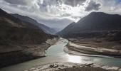
Certainly -- and I'll put it in simple terms. But I want to remind you that I am not a hydrologist. The Yarlung Tsangpo -- the Brahmaputra river -- stretches around 2,800 kilometres. Of this, about 1,625 kilometres flow through Tibet (China), roughly 850 kilometres through India, and the final 300 kilometres through Bangladesh.
At first glance, one might assume that since China hosts the longer segment, it must control more of the river's water. But that assumption doesn't hold up hydrologically.
What truly matters is not the river's length (what length of the river is in which country), but where the water comes from -- and here, the picture flips.
The Tibetan plateau receives relatively low rainfall compared to the lush, monsoon-fed catchments of India. The catchment receives significantly less snowmelt compared to the Indus Basin, where glacial contributions are far more substantial.
Studies show that only about 15% of the Brahmaputra's total annual discharge originates in China, while nearly 85% comes from within Indian territory and neighbouring Bhutan. This is where the Brahmaputra fundamentally differs from the Indus.
In the Indus system, India -- being upstream -- controls a significant share of the water before it reaches Pakistan. Geography, precipitation, and snowmelt patterns give India that leverage.
But in the Brahmaputra's case, despite being downstream, India actually receives more water than China does, due to the way the river gathers its flow.
So, unlike the Indus, where the upper riparian dominates water availability, the Brahmaputra is a rare case where the lower riparian -- India -- has the volume advantage.
It's a reminder that when it comes to rivers, location isn't everything -- rainfall, terrain, and tributary networks often matter more.
The mega-dam China is building that you spoke about... could the disruption of sediment flow by such Chinese infrastructure pose a serious long-term threat to the ecology of the Brahmaputra basin in India?
Absolutely -- it's a major but often overlooked risk.
One of the most critical ecological impacts of large upstream dams is their disruption of natural sediment flow.
Himalayan rivers like the Brahmaputra carry enormous volumes of sediment -- rich in minerals and nutrients -- that are vital for replenishing the fertile floodplains of North East India.
When a dam traps these sediments, two serious problems arise downstream. First, the river water that reaches India becomes 'clearer,' but ironically more dangerous. Sediment-laden water moves slower and is gentler.
But when that sediment is removed, the water becomes faster and more erosive -- like a knife without its blunt edge. It starts scouring the riverbed and carving into the banks, leading to heightened erosion, unstable channels, and even the shifting of the river's course over time.
Second, and just as important, is the loss of nutrients. Without regular deposits of sediment, the agricultural lands in Assam and other parts of the North East will suffer a gradual decline in soil fertility. This has long-term consequences for food security, rural livelihoods, and ecological stability in the basin.
So yes, beyond the political and hydrological concerns, sediment trapping by China's planned mega-dam presents a serious ecological and economic threat for India -- one that will quietly unfold over decades if not addressed.
Considering these concerns, what steps must India take internally -- through infrastructure, storage, or conservation -- to reduce our vulnerability to future upstream disruptions from China?
These challenges are real and growing. First, it's important to recognise that India doesn't have a formal water-sharing treaty with China -- only a memorandum of understanding for seasonal data sharing during floods.
This arrangement isn't legally binding and operates purely on goodwill. China has withheld such data in the past, reminding us that they control not just water, but critical information.
Diplomatically, India can explore building a coalition of lower riparian States -- Bangladesh, Bhutan, and Myanmar -- to raise collective concerns. But the political traction of such a front is uncertain.
The real solution lies in strengthening our internal resilience. India urgently needs a science-driven water strategy tailored to the Brahmaputra basin. This begins with detailed hydrological mapping and better monitoring of the river on our side.
We need to build integrated water storage infrastructure -- especially in Arunachal Pradesh -- that can absorb sudden releases from upstream and retain water for the dry season. This doesn't mean just mega-dams; it requires a layered network of large, medium, and small-scale storage projects.
Equally critical is modern flood management: Smart embankments, diversion channels, and inland navigation systems that can turn excess water into a resource rather than a threat. But all of this must be done sustainably, with local community involvement to ensure legitimacy and avoid internal friction.
Above all, India must respond not with panic, but with preparedness.
A united, forward-looking approach -- grounded in science, infrastructure, and regional diplomacy -- is our best bet against upstream risk.