'I am sure our DRDO will surely be on the job towards building similar capability to counter the threat posed by this Chinese helicopter,' observes Air Commodore Nitin Sathe (retd).


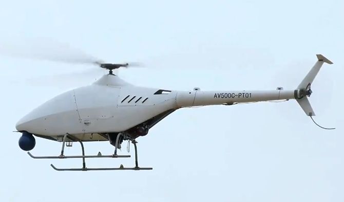
A recent news report on China's Unmanned Helicopter Drone seems to be more of a publicity stunt by the Chinese.
If one goes to the manufacturer AVIC's Web site, there is no mention of this helicopter drone.
Having been a helicopter pilot myself and closely associated with drone operations in the military I can counter the Chinese claim about the AR500c unmanned helicopter.

1. As of now this is a technology demonstration.
The helicopter only seems to have hovered and done some flight manoeuvres close to the ground (as seen in the video released).
In what time frame and when will the Chinese be able to prove the entire flight envelope of the claimed heights and speeds is the question.
And even if they do, how long will it take them to operationalise the system?
There is still a long way to go!

2. What is the payload it will be able to carry if it has to take off from a field at 16,000 feet?
That has not been specified anywhere.
As far as my knowledge goes, helicopter capability above 4 km to 4.5 km altitude tapers off drastically.
If a certain helicopter can carry 4 tons at sea level, the same machine taken to 12,000 feet would carry barely 20% of its stated capability.
So to carry out its mission, it would be forced to reduce the fuel carried which will have a direct bearing on the range and endurance of the machine.

3. The Chinese are known to pick up technology off the shelf and reverse engineer it for military use.
Here the Chinese are claiming use of the system from upwards of 5,000 metres altitude to 6,700 meters.(16,000 to 22,000 feet).
Machines designed to operate at such altitudes would require 'mil-standards' of equipment.
I have my doubts if equipment used in this machine is as per military specifications.
It is a known fact it is difficult and costly to produce equipment of military standards.
4. The airframe and engine, besides the ground crew who service the machine, would have to weather extreme cold conditions.
Ask a helicopter pilot the difficulties of operating and handling a machine at that altitude and he will tell you that it is tricky, you are operating at the edge of the flight envelope and there is very less margin for error.
In mountains, there exist strong winds and currents which make even manned helicopter operations difficult.
I wonder if the Chinese have developed the technology to counter the effects of all elements of weather -- a difficult proposition to say the least.
So, given the constraints of weather, will the machine be able to carry out 24/7/365 ops, a 'must' for operations, especially int gathering.
A dedicated anti-icing system on the helicopter is a must to operate in such conditions; have the Chinese been able to go around the weight penalties for fitment of such a system?
As far as my knowledge goes, the fitment of an appropriate anti-icing system for UAvs has been in the development phase so far.
Rubberised and plastic components as also the composite technology used in the machine make it very prone to failures in extreme cold conditions.
Composite technology is also very vulnerable to vagaries of weather.
Last but not the least, this is a very light machine as compared to a real helicopter.
The effect of winds and turbulence at that altitude on a small airframe would require highly sensitive and complicated flying controls.
Even when bigger helicopters operate at these altitudes, there are numerous occasions when flights cannot be undertaken due to weather limitations.

5. Certain Line of Sight issues which affect operations:
The helicopter has to operate in line of sight (LOS) of the ground control station.
In the mountains, to have a clear line of sight to advantage is a big problem.
So, your range will be drastically reduced in this sub-optimal LOS.
This can be remedied by use of satellite based control but how and where are they going to put the receiver antenna (on the UAV) out of the shadow of the rotors of the helicopter is the question that comes to mind.
The rotor system is a mass of rotating metal which is likely to interfere with the control signal from the satellite.
Also, the satellite also needs to be in 'view' of the ground control station(GCS) which is located in the mountains.
There is no workable technology that comes to mind when one can use the machine to the limits of its range in the mountains as of now.
Additionally, one needs to keep the GCS at a height from where it can get optimum range.
This is heavy equipment and in the absence of roads/connectivity to such high grounds, the location of the GCS would be more based on administrative convenience and may not provide for optimum ranges.

When one analyses the terrain on both the sides of the India-China divide, it is clear that if one pops up beyond the highest feature from the Indian side, one will be able to see for miles into Tibet, both visually as well as electronically.
But in the case of the Chinese, the undulating hills of the Himalayas till they merge with the Gangetic plain won't allow good clarity of view on both counts to them.
Today we can be happy with the fact that we have the equipment and platforms to look deep inside Tibet in every which way we want, and should this new unmanned Chinese helicopter appear on the horizon even earlier than what we think, it shouldn't be a cause for too much worry.
The wars of tomorrow will be based on accurate intelligence which is provided by ISR (Intelligence, Surveillance, Reconnaissance) platforms such as these unarmed aerial vehicles.
It has been proven time and again in all warfare, that he who has timely and accurate intelligence will have an upper hand over his adversary.
Every nation's war fighting capability is therefore based on its intelligence gathering machinery and expertise, a fact that should not be lost sight of.
Also, the wars of the future will be fought at large standoff distances and remotely; and therefore, the fighter aeroplane will have to give way to the unmanned vehicle in the years to come.
I am sure our DRDO will surely be on the job towards building similar capability in the near future to counter the threat posed by this Chinese helicopter.
We have much better experience than the Chinese of operating the Medium Altitude Long Endurance (MALE) systems in mountains and this should be further exploited to ensure that we are upto the task when required.
Overall, it is a signal for us to buck up in the race to obtain UAVs to operate in all terrain and weather conditions of the Indian subcontinent.
Aviation Industry Corporation of China (AVIC), a Chinese government company, has made a good beginning in producing a demonstration model of the unmanned helicopter and set the stage for the race for supremacy of unmanned vehicles in our sub-continent.
Production: Ashish Narsale/Rediff.com
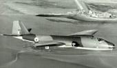
Air Commodore Nitin Sathe (retd) is a helicopter pilot who served the Indian Air Force for 35 years and was part of United Nations Peace Keeping Force operations in the Congo.