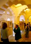
In a recent exhibition at Mumbai's National Gallery of Modern Art, architect PK Das put forth several ideas on how the problem of shrinking public spaces in Mumbai can be resolved and the city made a little more liveable. Abhishek Mande takes a look
Sample this: London has 31.68 sq m of open space per person; New York has 26.4 sq m; Mumbai on the other hand has 1.58 sq m which may soon get reduced to 0.87 sq m.
To put things into perspective, 31.68 sq m is equal to 341 sq ft and 26.4 sq m is a little over 284 sq ft. In Mumbai, these are sizes of thousands of lower middle class homes that are shared by at least four or more people.
1.58 sq m is about 17 sq ft, which if you look at it, is smaller than the size of an average prison cell (about 6 ft x 8 ft).
Indeed, one of the greatest challenges that Mumbai city has been facing is that of shrinking public spaces. If illegal hawkers and hutments aren't enough, builders constructing high-rise apartments are doing so at the cost of forest land and recreational areas among others.
In 'Open Mumbai' exhibition that ran at the National Gallery of Modern Art till May 6 and one that will soon move to the Nehru Centre where it will stay for the next three months, architect firm PK Das and Associates has put forth several ideas on how the problem of shrinking public spaces in Mumbai can be resolved.
The firm has been responsible for 'Reclaiming Juhu Beach', a movement that helped clean up Mumbai's iconic beach by relocating hawkers and recovering parts of the beach that were encroached upon by its affluent residents.
PK Das and Associates has also been associated with the promenades along two of Mumbai's famous waterfronts -- Carter Road and Bandstand (both in Bandra, in north-western Mumbai) -- as well as the restoration of Bandra Fort, converting the once decaying monument into a vibrant space for socio-cultural festivals.
'Open Mumbai' exhibition, an outcome of extensive research, meticulous planning and much thought, holds up examples of accomplished projects and suggests plans for similar makeovers.
Here are some projects that have changed the face of parts of Mumbai and some other proposed plans that will hopefully increase the public space further, enabling its citizens to breathe a little easy.
Please ....

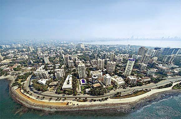
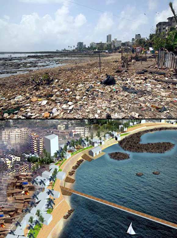
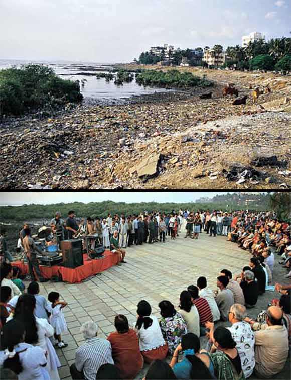
The city of Mumbai has over 14 km of beaches. However, unlike beaches in some other cities by the sea, those in Mumbai aren't always the most pleasant sight.
Many have turned into dumping yards and have been encroached upon by locals as well as immigrants who set up their businesses on the sandy grounds. Interestingly, and sadly, the city's sewers let out effluents on the shores which thanks to the tides ends up on the beaches, making them inaccessible. Once they are inaccessible they end up becoming backyards and home to unscrupulous elements.
PK Das, whose company put up the exhibition points out, in Mumbai things get complicated as multiple government agencies governing beaches initiate projects without so much consulting each other and those that are almost always in contradiction with each other.
"The Juhu beach for instance comes under as many as five government agencies including the Maritime Board as well as the National Airports Authority of India because of the presence of the flying club in the area," he says.
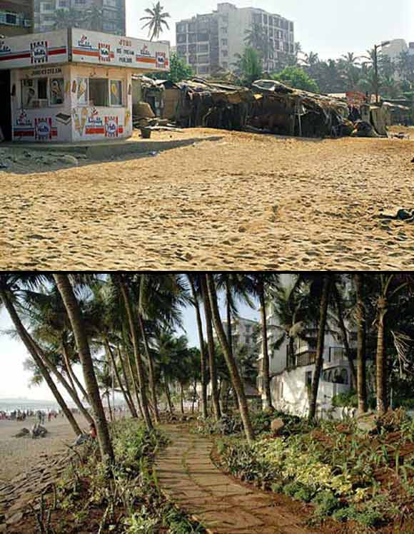
One of the prominent beaches in north Mumbai that stretches for about 4 km, Juhu had seen several encroachments -- not just by the poor but also by the rich.
"Hawkers had set up their stalls on sandy beaches and the rich had encroached by way of extending the boundaries of their properties on to the public beach. We had to fight that and get it cleared, which we did by filing public interest litigations in the high court and later in the Supreme Court.
"Once we got rid of the encroachment, we reclaimed the beach and gained a lot of land area which we developed as public parks."
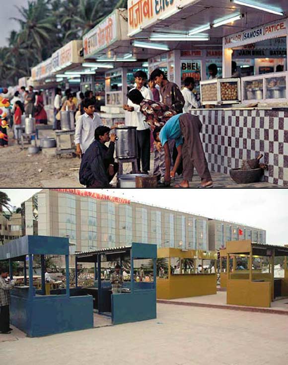
With regards to the hawkers, we ensured that we rehabilitated them mere 50 m away from the beach, giving them legal entitlements in a food court that stands on hard land rather than on the sandy beaches. We did this because we believe that in the process of redevelopment, we must recognise the ground realities and accommodate them rather than displacing them since they contribute to the economy of the city.
"Today the hawkers have legal space by the beach and no longer have to depend upon patronage of local gangs or political parties or bribe government officials."
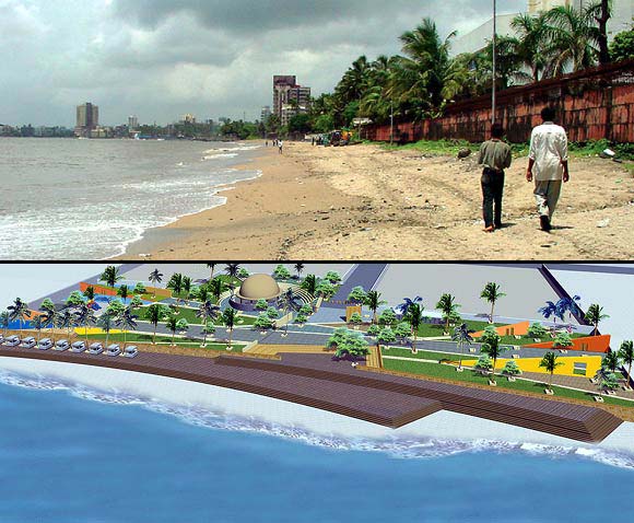
Perhaps the largest open space in Central Mumbai, the Dadar-Prabhadevi beach, is as long as the one in Juhu and is part of the larger Mahim Bay.
Das's website says the beach 'extends from Worli Village to Bandra Fort, (however) large parts of the sandy beach have eroded and most of it rendered inaccessible'.
Most of it, Das says, has over the years been vandalised mainly because of indiscriminate landfilling in other parts of the city.
Matters get complicated as owners of properties along this beach have dumped huge boulders along the boundaries to protect themselves from erosion.
According to Das, the beach has about 10 accesses that also provide entrance to the private properties on either side that are 'unplanned and irregular'.
With the nourishment plan that is underway, Das hopes to 'regenerate and expand the beach and thus recreate the enormous public space that the area was once proud of (and) redevelop the existing approach roads, gardens, hawkers' stalls, steps, ramps, podia and provide public conveniences, general lighting and security'.
"That way we hope not just to reclaim the public space but also check erosion by natural means and mechanism," he says.
Chimbai Beach is about a 1 km-long stretch of land that lies in between Carter Road and Bandstand in Bandra and houses a fishing village.
Das's plan that has been approved by the Mumbai municipal corporation includes building and formalising facilities where fishermen can anchor their boats, jetties so they are easily accessible, space for knitting their nets and boat repairs as well as creating terraces of sand and ground connecting Bandra Bandstand to Carter Road.
The idea, Das points out, is to 'fight the isolation of the area which has turned it into a backyard'.

PK Das and Associates already has to its credit the development programme they undertook in Bandra along Bandstand and Carter Road.
The Bandra Bandstand waterfront that was pretty much a wasteland with debris strewn along the 1.5km long stretch now has a charming promenade that has a great walking track as well as a central gallery of steps that takes you lower down to the water's edge, where there is space for get-togethers, art shows, music programmes and other such events.
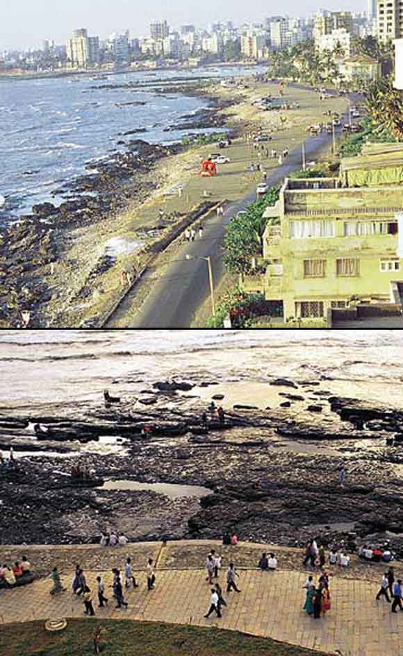
There also is a central garden with an expanse of lawns and furniture for seating and resting.
After being constructed, all of this is being maintained by local residents and is accessible to everyone and anyone.
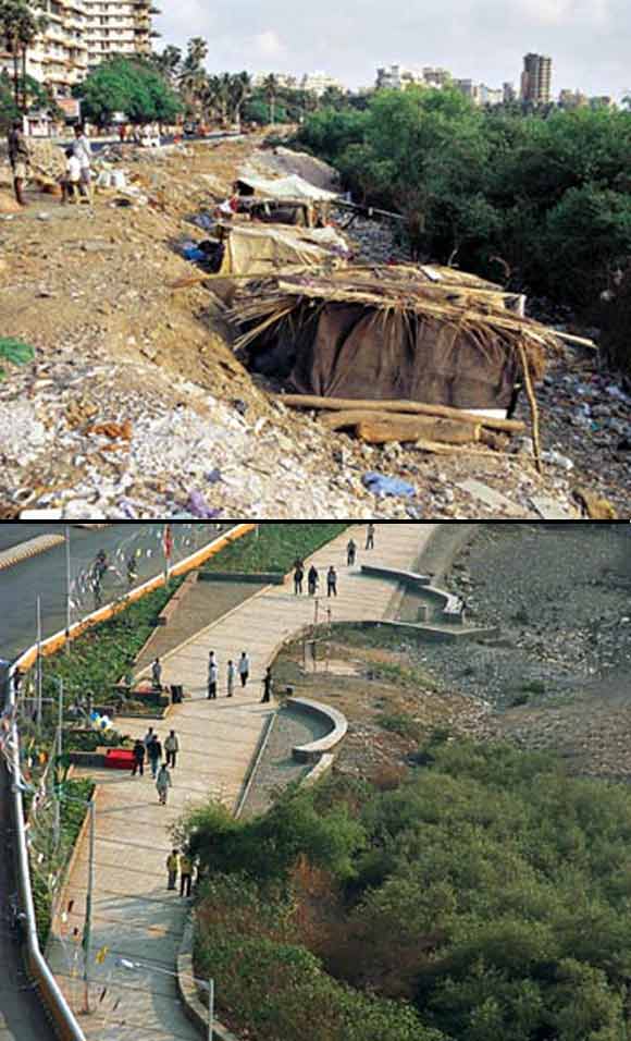
The Bandra Bandstand model has been replicated for the promenade that meanders around the mangroves along the Carter Road seafront. Running for about 1.3 km, the promenade has over 30 varieties of palm trees planted alongside.
Galleries of steps at two points along the stretch have become a prominent spot for get-togethers and cultural events.
This, Das says, is a part of the larger movement in the city to reclaim public spaces and to protect Mumbai's coastline and one that cannot be done by the government alone or be given to private parties who could eventually encroach upon the space, but rather a tripartite co-operation between the two involving the citizens who maintain it.
In a bid to develop the wetlands and mangrove swamps like the ones in Sewri that were declared a protected ecology in 1996 and are home to flamingos between the months of October and March, Das in his exhibition suggested construction of wooden ramps as well as cycling and walking tracks.
This fits in with Das's philosophy of integrating public spaces into the 'larger programmes for the city's development, with special emphasis on its social and environmental constitution'.

It may come as news to many Mumbaikars that their city has four rivers -- Oshiwara, Dahisar, Poisar and the most well-known Mithi of whose existence most had been blissfully unaware of till the floods of June 2005.
While Das hasn't as yet worked on rivers and nullahs (stormwater drains), his company has drawn up an elaborate plan for the restoration of their banks.
"Integration of the rivers and recognising how important they are is crucial," he says, "By declaring the river edges as public spaces, you can ensure that they cannot be encroached upon and at the same time maintain sensitive ecological conditions.
"We've mapped the rivers and have discovered that they cover 40 km of length. The 16 planned nullahs stretch over about 48 km. By developing cycling and walking tracks on both sides of these rivers and nullahs it is possible for the city to have almost 180 km of public space network."
Das laments the state of rivers such as Mithi, especially pointing out that the MMRDA that has developed and sold the Bandra-Kurla Complex has been completely blind towards the river that literally flows in their backyard. Developing it, he suggests, could only increase the value of the property of the complex and the areas around it.
The promenades and tracks that have been proposed along various waterfronts add up to create an almost 500 km of continuous cycling and walking track, Das points out.
"And it is doable," he says, "at a fairly low cost of about Rs 2,500 crore."

Being a city by the sea, Mumbai has six forts -- Sewri, Bandra, Sion, Kala, Worli and Mahim. Of these, only one fort -- the one at Bandra -- is really worth writing home about.
The Bandra Fort however has become a centre for cultural and social activities. It has been restored conscientiously, not half-heartedly using cement concrete, and the amphitheatre within the fort has been the scene of action for music concerts as well as play performances and corporate gatherings.
The conservation programme that started in 2003 by the Bandra Bandstand Residents' Trust was spearheaded by Shabana Azmi, who allotted funds for the effort.
Today, the brick arch of one of the gateways that was almost on the verge of collapse and the fort wall's foundation masonry have been repaired and the fort itself has undergone a makeover with the natural rock formations being preserved.
Sadly, the same cannot be said about other forts that have fallen into ruins -- ones like the Worli Fort are used by local slum-dwellers to sleep at night.
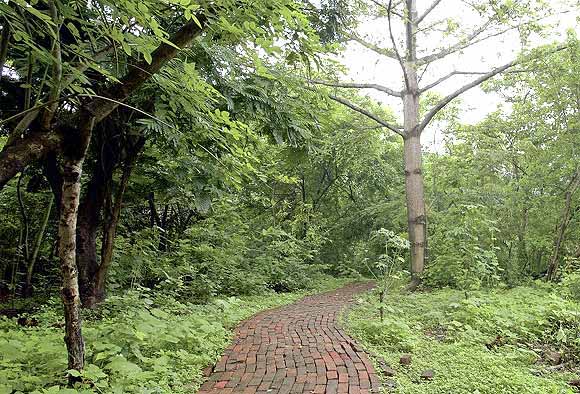
Besides Sanjay Gandhi National Park, Aarey Milk Colony and the forests on Mandala and Gilbert Hill, the entire forest cover in the city is spread across a little over 64 sq km. While these are natural forests, some like the Mahim Nature Park in Dharavi, Mumbai Port Trust Garden in Colaba and the Jijamata Udyan in Byculla are city forests.
The Mahim Nature Park is located on the southern bank of the Mithi River and was once a garbage dump till the World Wildlife Fund India conceived it as a nature park back in the 1970s.
With over 200 species of trees and about 80 species of birds and 38 species of butterflies, the Mahim Nature Park is a haven in a city starved for space.
On the absolute southern tip of the city stands the Mumbai Port Trust garden near Colaba Causeway offering great views of the port and naval yards and is home to some of the greenest pastures of land in South Mumbai.
The most popular of the three is the Jijamata Udyaan in Byculla quite simply because it houses a zoo as well as a museum. According to the figures in the exhibition, these city forests cover an area of 0.31sq km, and Das has proposed similar city forests in the Goregaon (west), a suburb along city's western railway line and Chembur (west) a suburb that is one of the most highly congested, along the city's harbour line. The total area of these forests by some estimates should increase the city forest cover to 1.5 sq km.
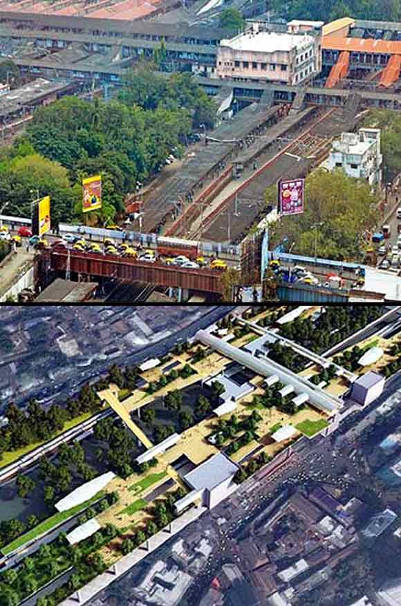
Perhaps the most interesting concept suggested by Das involves changing the face of railway stations that form a major part of Mumbaikars' livelihood.
By some estimates over 7 million people use the railways every day to travel to and from work. The city itself has 51 railway stations that PK Das hopes to make the most of by creating rooftop plazas.
Das's plan to connect all the platforms at Dadar railway station as well as the ones in Khar by creating rooftop plazas has been approved and should get underway soon.
By replicating this, Das hopes to create more than 155 acres of public space.
The key, Das says, to the success of all these efforts lies as much in the hands of the local citizens as much as it is in the hands of the government.
...