India has been blessed with some of the most beautiful and significant pilgrimage destinations, and the awe-inspiring Himalayas, considered to be the sacred resting place of the gods, attract not just pilgrims but avid trekkers, adventure enthusiasts and nature lovers as well.
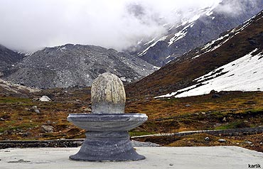
Our destination was Kedarnath in Uttarakhand, one of the 12 Jyotirlingas (shrines) of Lord Shiva.
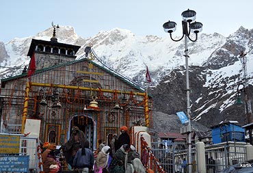
Kedarnath is located at a height of 3,584 metres in the Rudraprayag District. It is one of the Char Dhams (four main revered pilgrimage sites) in the Garhwal Himalayas. The Chardham Yatra comprises of a pilgrimage to Badrinath, Kedarnath, Gangotri and Yamunotri in Uttarakhand.
We set off from Delhi on Friday night in a hired taxi. We had to stop at Rishikesh (227 km from Delhi), as tourist vehicles are not allowed beyond Rishikesh between 8 pm and 4:30 am.
We left Rishikesh at 4.30 am sharp for Gaurikund and arrived at around noon (209 km ex-Rishikesh).
The Border Road Organisation, along with the state government has done a commendable job with the roads and infrastructure.
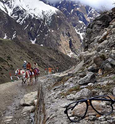
Gaurikund is where the motorable road ends and one has to cover the 14 km distance to Kedarnath either on foot or on a pony or palkhi (palanquin).
The hiking path is well marked and with a gradual gradient, hence the trek is comfortably achievable for most trekkers without much huffing and puffing.
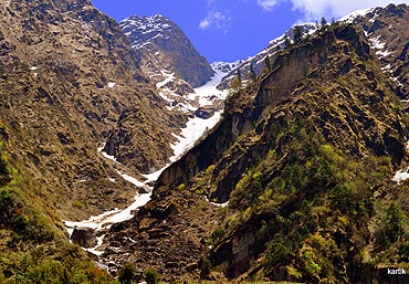
For nature lovers, there is abundant beauty, from dense forests to magnificent waterfalls.
The weather at these heights, we were told, tends to get a bit unpredictable, which we soon found out for ourselves when the bright sunshine that we enjoyed for a good part of the day was suddenly washed away with torrential rains, all in a span of 15 minutes.
At 6 pm we decided to halt for the night at Rambara (2,591 metres), 7 km from Gairkund. This place is an ideal spot for star-gazers as there is no electricity in the village.
There is also no mobile signal for the better part of the 14 km trek, although you do get network as you get closer to Kedarnath and Gaurikund.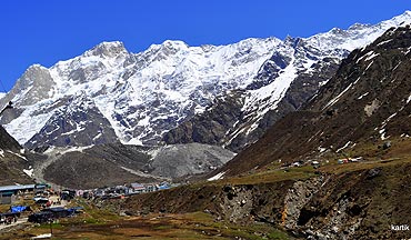
The landscape changes dramatically, from dense forest to treeless open land as one goes further up. The snow-capped Kedar range comes into view as one gets past Rambara.
Our three-hour trek to Kedarnath through beautiful meadows included lots of photography sessions with wonderful views of the glaciers. The lucky ones even got to see some wildlife.

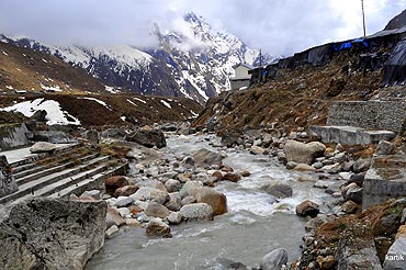
The small town of Kedarnath is a revelation in itself. The place provides ample options in terms of boarding and lodging right from the state-run GMVN guest house to private dharamshalas and lodgings.
On reaching Kedarnath, we bunked in a lodge and went to pay our respects at the Lord Shiva shrine before going to explore the area around the place.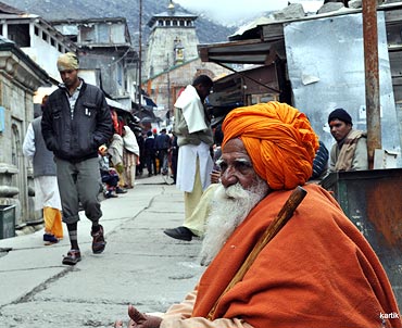
Since it was just the start of the season, the place was relatively quiet and we were happy visiting the Bhairon Temple (a half a kilometre hike from the main temple) and the Adi Shanaracharya Samadhi Sthal, silencing our inner turmoil in peace and solitude.
Those interested in learning about the life and philosophy of sanyaas can get talking to the sadhus who flock to the temple. The other places to visit near Kedarnath are Gandhi Sarovar(a 3 km trek) and Vasuki Taal (an 8 km trek).
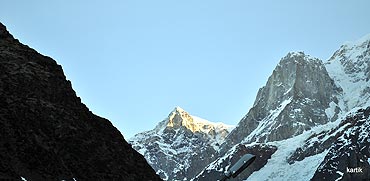
The following day we woke up early to watch the first rays of the rising sun fall on Kedar Peak, before embarking upon our return journey.
As we trekked back towards Gaurikund, we kept looking towards the mountain range for a glimpse of the mesmerising Kedar range, its sheer beauty leaving a lasting memory in our minds.
The best season to visit is either early May or end September onwards, as the monsoons start subsiding. Please check the opening/ closing dates of the temple prior to departure.
How to reach
Kedarnath is a 14 km trek from Gaurikund, where the motorable road ends. You can also hire a pony or go up in a palkhi (four sherpas carry you).
Helicopter services are also available from Guptkashi and Agastya Muni in the Rudraprayag District.
Gaurikund is well-connected by road from Rishikesh, Dehradun, Haridwar and Kothdwar.
The nearest airport is at Dehradun, 224 km from Gaurikund.
The closest railway station is at Haridwar, 221 km.
Want to share your travel story with us and others around the world? Simply write an email (with the subject line: 'My Travel Story') and send it to getahead@rediff.co.in! Also send us pictures of the place you're writing about. We will publish the best ones right here on rediff.com!