
In August 1998, the observatory had received 261.9 mm rainfall in 24 hours which was a record for the month till now, but Wednesday's rain broke it within only 12 hours.
After two days of moderate showers, the met department on Friday forecast "intense heavy rainfall" in Mumbai on late Saturday and Sunday.

Apart from the metropolis, several other parts of Maharashtra also reported a drop in night temperatures, resulting in chill and cool breeze in those areas.
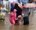
However, some areas in south Mumbai, which witnessed a record rain on Wednesday, were still water-logged, they said. The India Meteorological Department (IMD) has predicted moderate to heavy rainfall in the city and suburbs and intense showers in some parts of the Mumbai Metropolitan Region in next 24 hours.

The IMD has forecast heavy rainfall in some parts of the state in next 48 hours. "The southwest monsoon has arrived in Maharashtra. The onset line is passing over Harnai, Solapur, Ramagundum (Telangana) and Jagdalpur (Chhattisgarh)," IMD Mumbai centre's deputy director general K S Hosalikar said.

The orange alert implies that authorities should be ready to handle situations arising out of severe weather.

The cyclone is likely to bring heavy rainfall in its wake in parts of Maharashtra, Gujarat and Goa. The light showers/drizzle in parts of Mumbai city, its suburbs and neighbouring districts of Thane and Palghar on Monday morning brought some respite to people from the sweltering heat and humidity.

With the cyclone set to make landfall on Wednesday, Maharashtra and Gujarat activated their disaster response mechanism, deploying NDRF teams and evacuating people from areas likely to be hit.

'Very heavy with isolated extremely heavy rainfall (>200mm) forecasted for N Konkan including Mumbai in 24 hrs. Entire west coast very active monsoon'

The Indian Meteorological Department, meanwhile, warned of intense spell of 30 to 50 mm rainfall per hour with strong winds in Mumbai and suburban areas.

It is the highest rainfall of the season so far in 24 hours.

The Santacruz observatory recorded 286.4 mm rainfall during the 24-hour period ending at 8.30 am on Wednesday, making it the fourth highest rainfall in Mumbai since 1974, an Indian Meteorological Department official said.

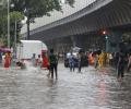
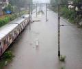
Heavy rains lashed Mumbai and its suburbs on Wednesday, causing flooding on roads and rail tracks and disrupting suburban train services as the south-west monsoon arrived in the city with a bang, while the India Meteorological Department (IMD) issued an alert for more downpour.

The India Meteorological Department (IMD) has forecast 'extremely heavy rains' at a few places in Marathwada, Mumbai and other parts of the coastal Konkan region of Maharashtra in the next 24 hours.

Mumbai and certain adjoining areas experienced pre-monsoon showers, sources said on Sunday.

Intense spells of rain are likely to continue in the districts of Thane, Raigad and Mumbai during next four hours, the India Meteorological Department (IMD) said.
Waterlogging has been reported in several parts of city.

However, flight operations at the Mumbai airport were not impacted due to rains, an airport official said.

The two western states, already battling a raging pandemic, which has put their health infrastructure under severe strain, opened new fronts to tackle the fallout of the storm which is expected to make a landfall close to Mumbai on Wednesday. They are likely to be impacted most by the cyclone.
Waterlogging was reported from areas like Dadar, Wadala, Worli, Kurla, Chembur, Bandra, Andheri, Kandivili, Vikhroli, Kanjurmarg and Bhandup, among others.

In an unprecedented measure, the Maharashtra government requested defence officials to arrange airlift of the stranded passengers of the 17412 Mahalaxmi Express.