 | « Back to article | Print this article |
PICS: NASA's satellite clicks UNSEEN events on earth
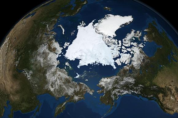
Aqua, Latin for water, is a NASA Earth Science satellite mission named for the large amount of information that the mission is collecting about the Earth's water cycle, including evaporation from the oceans, water vapor in the atmosphere, clouds, precipitation, soil moisture, sea ice, land ice, and snow cover on the land and ice.
Aqua was launched on May 4, 2002, and has six Earth-observing instruments on board, collecting a variety of global data sets.
Rediff.com brings you pictures taken by the satellite over the years.
Click NEXT to read further...
PICS: NASA's satellite clicks UNSEEN events on earth
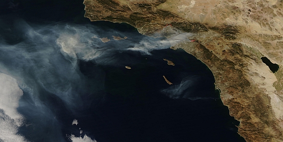
This image from the Moderate Resolution Imaging Spectroradiometer on NASA's Aqua satellite shows the Los Angeles metropolitan area on November 16, 2008.
Places where the sensor detected active fires are outlined in red. The image shows smoke spreading far to the west over the Pacific Ocean. The Sayre Fire north of San Fernando was 8,000 acres and 20 per cent contained.
The Freeway Fire was 5,800 acres and 5 percent contained.
Click NEXT to read further...
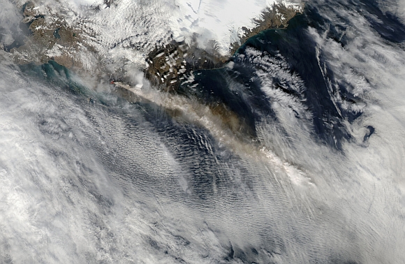
PICS: NASA's satellite clicks UNSEEN events on earth
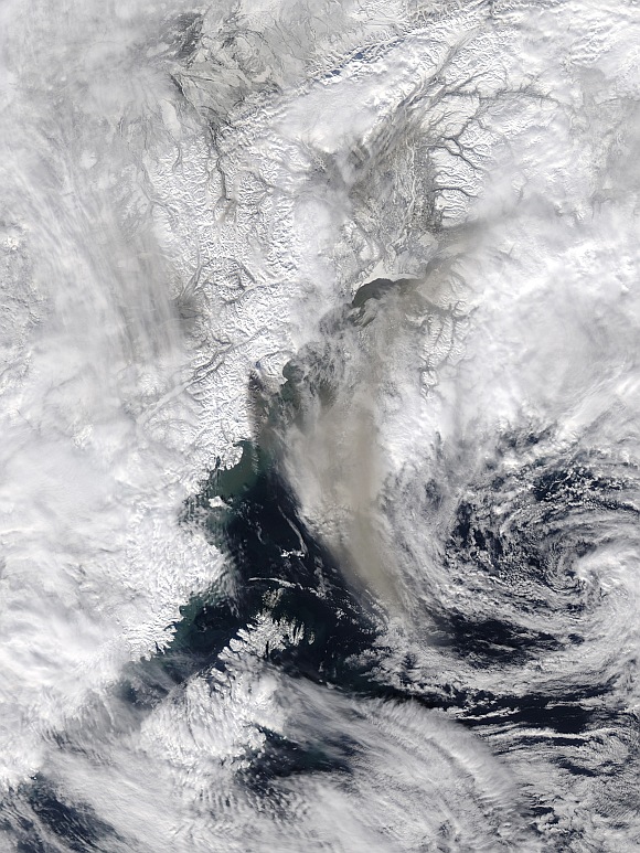
NASA's Aqua satellite captured this image of the aftermath of the eruption Alaska's Mount Redoubt erupted on March 26, 2009.
The volcano sent a plume of ash at least 65,000 feet above sea level. A cloud of tan ash extends from the volcano south and east. The ash colors the clouds south of Anchorage, an indication that the volcanic plume rose above the cloud level.
A dark-colored streak extends south of the volcano where ash had fallen on the snow.
Click NEXT to read further...
PICS: NASA's satellite clicks UNSEEN events on earth
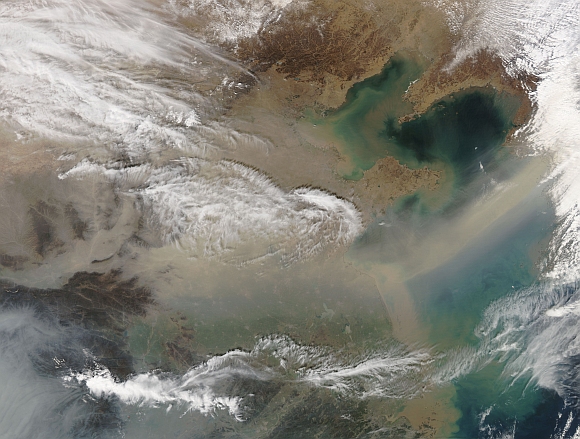
An Aqua satellite image provided by NASA of a large dust storm sweeping across eastern China, March 12, 2010.
Tons of sand carried by winds of up to 100 km/h affected more than 270 million people in 16 provinces, covering about 2 million square kilometres.
Click NEXT to read further...
PICS: NASA's satellite clicks UNSEEN events on earth
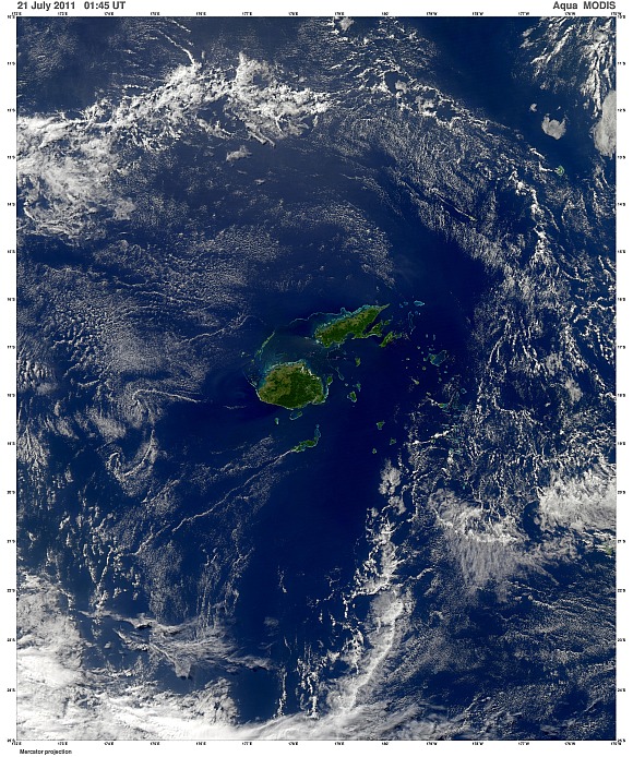
The Fijian Islands of Viti Levu and Vanua Levu (right) are seen in this image captured by Moderate Resolution Imaging Spectroradiomete on NASA's Aqua satellite on July 21, 2011.
Above Vanua Levu, the Cakaulevu Reef is visible.
Click NEXT to read further...
PICS: NASA's satellite clicks UNSEEN events on earth
A view of the Eyjafjallajokull volcano in Iceland taken by NASA's Aqua satellite shows a visible image of its ash plume, as seen in this handout photo taken on May 4.
Despite the abundance of clouds in the area, the plume appears as a thin line of darker clouds streaming from the center of the image toward the southeast.
Click NEXT to read further...
PICS: NASA's satellite clicks UNSEEN events on earth
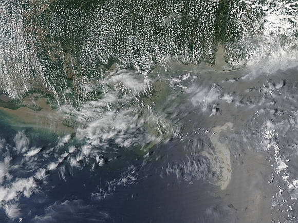
This image from the Moderate Resolution Imaging Spectroradiometer on NASA's Aqua satellite taken May 11, 2010, shows that the damaged Deepwater Horizon oil well that continued to leak significant amounts of oil in the Gulf of Mexico.
Oil slicks become most visible in photo-like satellite images when they appear in a swath of the image called the sunglint region, where the mirror-like reflection of the Sun is blurred by ocean waves into a washed-out strip of brightness.
The slick appears as a silvery-gray patch in the center of the image. The tip of the Mississippi Delta is at upper left. Wispy clouds make it hard to determine whether any of the streamers or smaller patches of oil extend northeast of the main spill.
Click NEXT to read further...
PICS: NASA's satellite clicks UNSEEN events on earth
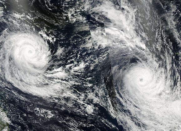
Tropical Cyclones Ului (left) and Tomas and are seen in the southwestern Pacific Ocean on March 16, 2010 in this combination photo, captured by the Aqua and Terra satellites.
Click NEXT to read further...
PICS: NASA's satellite clicks UNSEEN events on earth
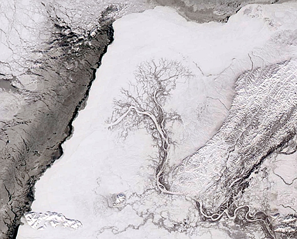
As spring nears, the silvery outline of a tree appears in western Alaska in the northernmost part of the United States, as waking-up streams weave across the wetlands of the Yukon Delta, in this photo taken on March 8, 2004.
To the west, the Bering Sea begins to soften the frozen shoreline.
Click NEXT to read further...
PICS: NASA's satellite clicks UNSEEN events on earth
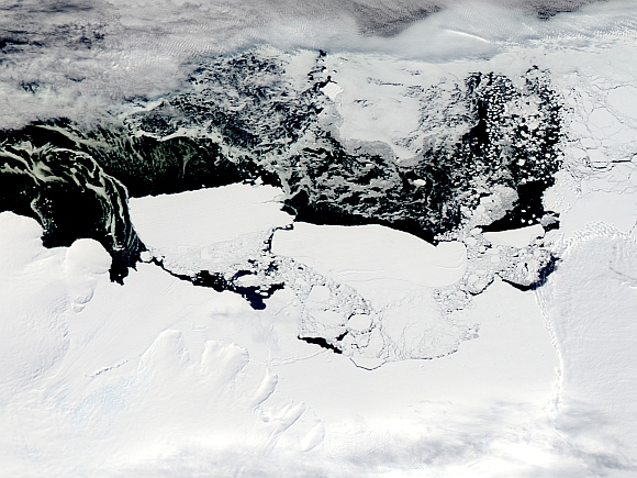
The Mertz Glacier Tongue (centre, left) breaks away from the Mertz Glacier in this image on February 26, 2010.
An iceberg's crash into the glacier in East Antarctica last year broke off nearly 78 km of glacier tongue, exposed a section of ocean water previously covered in hundreds of meters of ice and brought to light marine life including sea stars as big as hubcaps, bringing to light a vast span of the Southern Ocean and providing scientists with a chance to conduct experiments that may help understand climate change.
TOP photo features of the week
Click on MORE to see another set of PHOTO features...