| « Back to article | Print this article |
AMAZING VIEWS: Himalayas, Ganga, more from space!
Launched in 2002, European Space Agency's Envisat is the largest Earth observation spacecraft ever built.
It carries ten sophisticated optical and radar instruments to provide continuous observation and monitoring of the Earth's land, atmosphere, oceans and ice caps.
The satellite has orbited Earth more than 50,000 times and has lived twice as long as planned, a Wired Science report stated.
Rediff.com presents some of the amazing pictures captured by Envisat over the years, as it completes a decade in space.
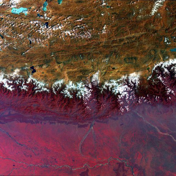
This Envisat image captures Asia's diverse topography, altitude and climate with the snow-sprinkled Himalayan Mountains marking the barrier between the peaks of the Tibetan Plateau (top) in Central Asia and the plains of Nepal, Buthan and India in the Indian subcontinent. In this false-colour image, lush or green vegetation appears bright red.
This image was acquired by Envisat's Medium Resolution Imaging Spectrometer instrument on February 20, 2009, working in full resolution mode to provide a spatial resolution of 300 m.
The Ganga river, the most important of the Indian subcontinent, is visible across the image bottom.
Click on NEXT for more...
Click here for more Realtime News!
Ganga delta
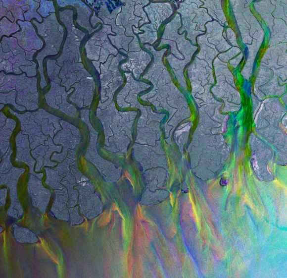
This Envisat image highlights the Ganga Delta, the world's largest delta, in the South Asia area of Bangladesh (visible) and India.
The delta plain, about 350-km wide along the Bay of Bengal, is formed by the confluence of the rivers Ganga, Brahmaputra and Meghna.
As radar images represent surface backscatter rather than reflected light, there is no colour in a standard radar image. This image was created by combining three Envisat Advanced Synthetic Aperture Radar acquisitions (Jan 20, 2009, Feb 24, 2009 and March 31, 2009) taken over the same area.
The colours in the image result from variations in the surface that occurred between acquisitions.
Click on NEXT for more...
Canary Island archipelago
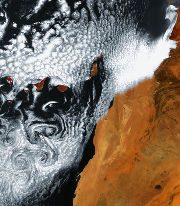
This false-colour Envisat image, acquired on June 6, 2010, highlights a unique cloud formation south of the Canary Island archipelago, some 95 km from the northwest coast of Africa (right) in the Atlantic Ocean.
Seven larger islands and a few smaller ones make up the Canaries; the larger islands are (left to right): El Hierro, La Palma, La Gomera, Tenerife, Gran Canaria, Fuerteventura and Lanzarote.
Click on NEXT for more...
The McClure Strait, Canada
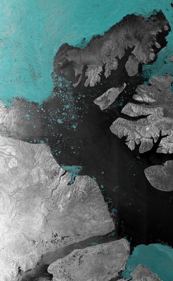
Envisat ASAR image of the McClure Strait in the Canadian Arctic Archipelago, acquired on August 31, 2007.
The McClure Strait is the most direct route of the Northwest Passage and has been fully open since early August 2007.
Click on NEXT for more...
Algerian Sahara
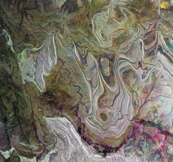
Envisat radar image of the Tanezrouft Basin in the Algerian Sahara. Radar images reveal surface roughness -- the rougher the surface, the brighter it appears. Hence, darker areas represent softer rock with a sandy or small-stoned surface.
This image was created by combining three Envisat radar passes (March 23, 2009, June 1, 2009 and Sep. 14, 2009) over the same area. The colours result from changes in the surface between acquisitions.
Click on NEXT for more...
Galapagos Islands
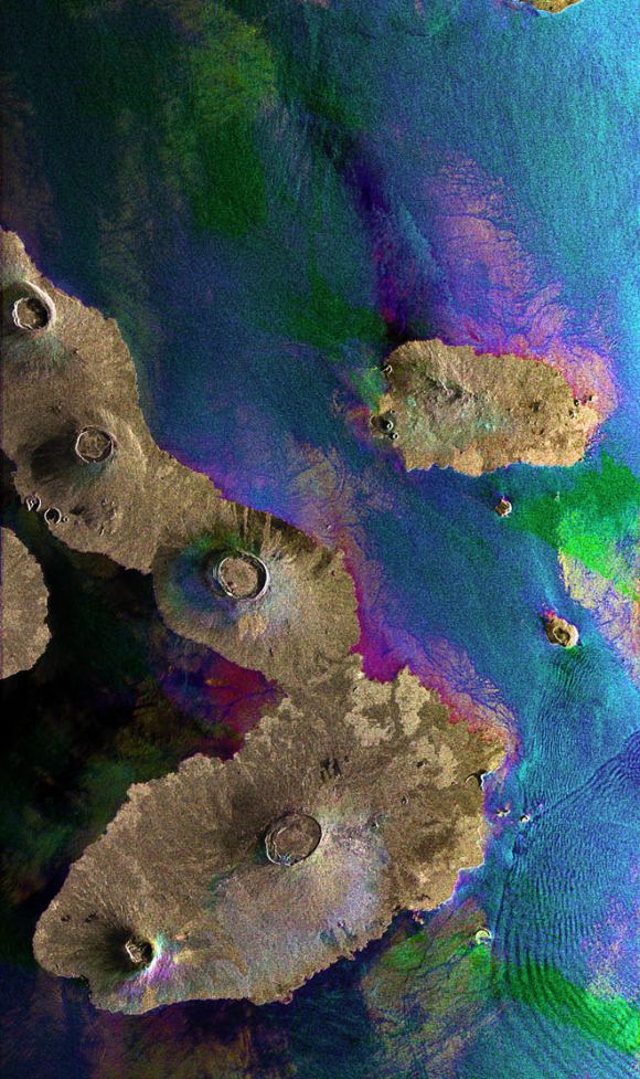
This Envisat image features the Galapagos Islands, an archipelago situated some 1,000 km to the west of Ecuador in the Pacific Ocean.
Galapagos's largest island is Isabela (visible). The five volcanoes seen on the island are (from north to south): Wolf Volcano, Darwin Volcano, Alcedo Volcano, Sierra Negra Volcano and Cerro Azul Volcano. The bigger island to the right of Isabela is Santiago Island.
The image was obtained by combining three Advanced Synthetic Aperture Radar (ASAR) acquisitions (March 23, 2006, Aug. 14, 2008 and Jan. 1, 2009) taken over the same area.
The colours in the image result from variations in the surface that occurred between acquisitions. Apart from mapping changes on the land surface, radar data can also be used to determine sea surface parameters like wind speed, wind direction and wave height.
Different wave types and wind speeds are visible in the image as ripples on the water surface.
Click on NEXT for more...
Ireland

Resembling the brush strokes of French Impressionist Claude Monet, electric blue-coloured plankton blooms swirl in the North Atlantic Ocean off Ireland in this Envisat image.
Plankton, the most abundant type of life found in the ocean, are microscopic marine plants that drift on or near the surface of the sea.
While individually microscopic, the chlorophyll they use for photosynthesis collectively tints the surrounding ocean waters, providing a means of detecting these tiny organisms from space with dedicated "ocean colour" sensors, like Envisat's Medium Resolution Imaging Spectrometer (MERIS), which acquired this image on May 23, 2010 at a resolution of 300 m.
Click on NEXT for more...
'Wild Wild' West
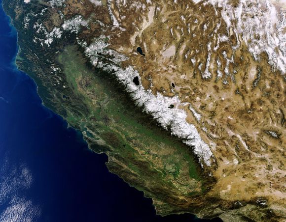
The contrasting landscape of the western US states of California (left) and Nevada (right) are highlighted in this Envisat image, acquired Februray 9, 2011.
The Sierra Nevada mountain range (snow-capped) runs along California's eastern edge. Lake Tahoe (visible) is located in the Sierra Nevada on the California–Nevada border.
Also visible in the image are the California cities of San Francisco (whitish area on the peninsula surrounding the San Francisco Bay, center left) and Los Angeles (sprawling grey area, bottom left).
Click on NEXT for more...
Kamchatka Peninsula
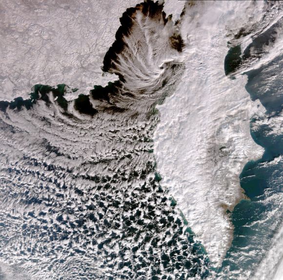
This image, acquired by Envisat's Medium Resolution Imaging Spectrometer (MERIS) instrument on November 12, 2009, captures the rugged and remote Kamchatka Peninsula on Russia's east coast.
The 1,250-km long peninsula lies between the Pacific Ocean to the east and the Sea of Okhotsk to the west.
Click on NEXT for more...
Hurricane Katrina
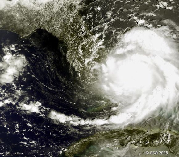
Hurricane Katrina as seen by Envisat's MERIS in Reduced Resolution mode, off southern Florida on August 25, 2005, when it was still Category One on the Saffir-Simpson scale measuring hurricane intensity.
The storm caused great damage after landfall, mostly due to heavy rainfall.
Click on NEXT for more...
Great Barrier Reef
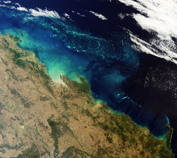
This Envisat image features one of the natural wonders of the world -- the Great Barrier Reef in the Coral Sea off the east coast of Queensland, Australia.
Australian researchers have discovered that Envisat's Medium Resolution Imaging Spectrometer sensor can detect coral bleaching down to 10 m deep.
This means Envisat could potentially map coral bleaching on a global scale. MERIS acquired this image on May 18, 2008, working in full resolution mode to yield a spatial resolution of 300 m.
Click on NEXT for more...
Mt Etna erupting

This Envisat MERIS image, acquired on January 11, 2011, shows the plume of smoke billowing into the atmosphere from Mount Etna, Sicily, Italy.
Activity gradually increased the following day, peaking in the evening.
Click on NEXT for more...
Strait of Gibraltar
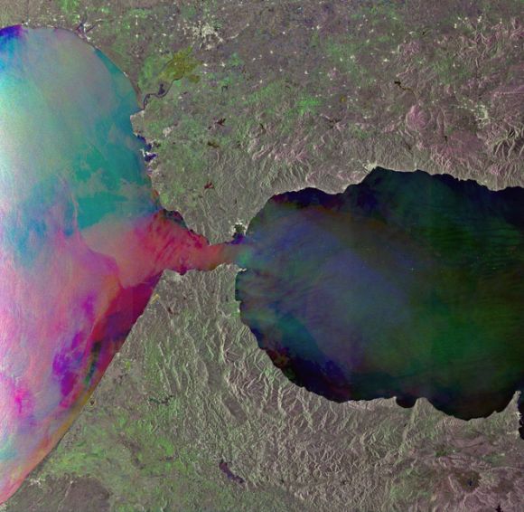
This Envisat radar image shows internal waves in the Strait of Gibraltar, between the southern coast of Spain (top) and the northern coast of Morocco.
From space, internal waves can be detected very efficiently using Synthetic Aperture Radar instruments that are sensitive to changes in the small-scale surface roughness on the ocean surface.
Internal waves in this image show up as a semi-circular rippled pattern east of the strait's entrance in the Mediterranean Sea.
Additional sets of internal waves generated in the Atlantic Ocean are visible as dark pink lines on the western side of the strait.
This image was created by combining three Envisat SAR acquisitions (August 12, 2010, October 1, 2009 and August 27, 2009) over the same area. The colours result from changes in the surface between acquisitions.
Click on NEXT for more...
Hawaiian Islands
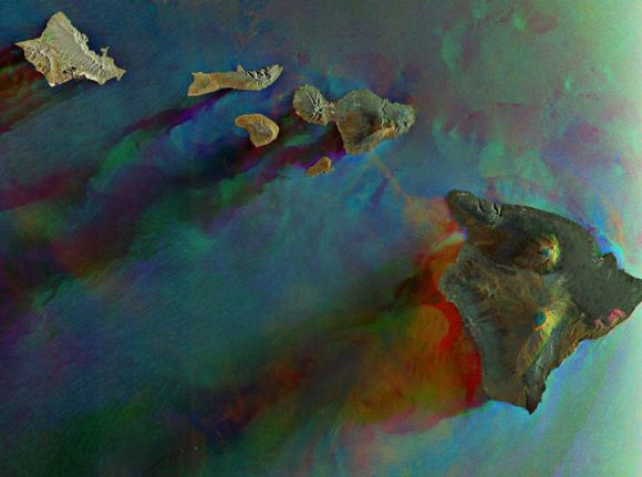
This Envisat radar image features six of Hawaii's eight major volcanic islands. Visible from right to left are the Big Island of Hawaii, Kahoolawe, Maui, Lanai, Molokai and Oahu.
In addition to two other major islands, there are also 124 islets.
This image was created by combining three Envisat ASAR acquisitions (March 27, 2006, April 16, 2007 and January 21, 2008) taken over the same area.
The colours in the image result from variations in the surface that occurred between acquisitions.
Click on NEXT for more...
Magnetic North Pole

Sea ice around the North Magnetic Pole, a wandering point on the Earth's surface, is featured in this Envisat radar image, acquired on December 8, 2008.
Just as Earth has two geographic poles, the North Pole and the South Pole, it also has a North and South Magnetic Pole.
Although the geographic and magnetic poles are near each other, they are not located in the same places.
Currently, the North Magnetic Pole is located in the Canadian Arctic at approximately 82.7 north and 114.24 west.
Click on NEXT for more...