 | « Back to article | Print this article |
IN GRAPHICS: The search for missing Flight MH370
Now this has really been one of the most baffling stories of our times. Barely an hour after taking off from Kuala Lumpur International Airport, a Beijing-bound Malaysian Airlines operated Boeing 777-200ER -- Flight MH370 -- disappeared in thin air with 227 passengers and 12 crew members from as many as 15 countries.
Twelve days since the strange disappearance, and literally the entire world on the edge of its seat trying to predict its fate, the MH370 continues to remain untraced. As of March 18, there are 26 countries participating in the revised search, focusing on a northern locus from the Kazakh-Turkmen border to northern Thailand, as well as a southern locus from Indonesia to the southern Indian Ocean, even extending to Australia.
Rediff.com’s Reuben NV presents some graphics to showcase the entire story of the missing flight.
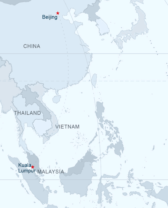
On March 8, Saturday, Flight MH370 took off from the Malaysian capital at 12:41 am (local time) and was supposed to touch down in Beijing at 6:30 am the same day after covering a distance of approximately 4,350 kilometres.
However, at around 1:30 am, air traffic controllers in Subang, outside Kuala Lumpur, lost contact with the plane over the sea between Malaysia and Vietnam. The aircraft's last known position was 6°55′15″N 103°34′43″E, at which point it was supposed to alter its course slightly eastward, and had enough fuel for 8 hours of flying.
The aircraft was also expected to contact air traffic control in Ho Chi Minh City as it passed into Vietnamese airspace.
“The New Straits Times reported on March 9 that the captain of another aircraft had attempted to reach the pilots of MH370 "just after 1:30 am" to relay Vietnamese Air Traffic Control's request for MH370 to contact it. The captain said he was able to establish contact but just heard "mumbling" and static,” media reports stated.
On March 11, a senior Malaysian air force official said the flight was hundreds of miles off course and traveling in the opposite direction from its original destination. It was last tracked over over Pulau Perak, a tiny island in the Strait of Malacca at about 2:40 am, over an hour after air traffic controllers in Subang lost contact with the aircraft.
Please click NEXT to see the graphic on the initial search operations…
The initial search operations

Early search efforts generated multiple false leads. An admiral of the Vietnamese Navy reported that radar contact with the aircraft was last made over the Gulf of Thailand. Oil slicks detected off the coast of Vietnam on March 8 and 9 later tested negative for aviation fuel. The alleged discovery of debris about 80 kiloemtres south of Thi Chu Island on March 9 was also found to be not from an aircraft.
Searches following a Chinese website's satellite images showing three floating objects also turned out to be damp squib, media reports suggested.
It was then that the Royal Thai Navy shifted its focus in the search away from the Gulf of Thailand and the South China Sea at the request of its Malaysian counterpart, which was investigating the possibility that the aircraft had turned around and could have gone down in the Andaman Sea, near Thailand's border.
On March 12, authorities also began to search the Andaman Sea, northwest of the Strait of Malacca, and the Malaysian government requested help from India to search in the area.
On March 17, Australia agreed to lead the search in the southern locus from Sumatra to the southern Indian Ocean.
Based on fuel estimates, the aircraft could have flown an additional 2,500 miles after the point of last contact. Malaysian authorities said Thursday they believe several "pings" of data from the airliner's service data system, known as ACARS, transmitted to satellites in the four to five hours after the last transponder signal, a senior US official told CNN.
This new information, combined with known radar data and knowledge of fuel range leads officials to believe the plane may have made it to the Indian Ocean.
The total area now being searched stands at 2.24 million square nautical miles -- nearly the size of continental United States of America.
Please click NEXT to see the graphic on the extended search operations and latest revelations…
The extended search
Although Bloomberg News said that analysis of the last satellite "ping" received suggested a last known location approximately 1,600 kilometres west of Perth, Australia, Malaysian Prime Minister Najib Razak on March 15 said that the last signal, which was received at 08:11 Malaysian time, might have originated from as far north as Kazakhstan.
Razzak explained that the signals could not be more precisely located than to one of two possible loci: a northern locus stretching approximately from the border of Kazakhstan and Turkmenistan to northern Thailand, or a southern locus stretching from Indonesia to the southern Indian Ocean.
“While official contact was lost with Flight 370 about 45 minutes after takeoff, officials believe a combination of military radar data and a satellite-based system called ACARS provide hints regarding the path of the plane,” CNN reported.
Though no actual data was transmitted via satellite, it still appears to have made contact through hourly 'handshakes,' the last instance being at 8:11 a.m. local time somewhere along the red lines.
Please click MORE to find out 12 weird conspiracy theories behind the missing MH370 saga...