'We need an early warning system in India.'

"A large volume of water was flowing through a very narrow gorge, just above Reni village. The slope was extremely high and the valley very narrow -- this is the reason it shot like a jet," says Dr Mohammed Farooq Azam, assistant professor, IIT-Indore with a long experience in glaciology and hydrology.
Dr Farooq Azam has a PhD in earth sciences from the University of Grenoble, France and his research is focused on the glaciology, hydrology, and climate change in the Indian Himalayas.
Dr Azam discussed the reasons for the February 7 glacier collapse in Uttarakhand with Rediff.com's Archana Masih.
It is being said that a part of the glacier broke and collapsed into the Dhauli Ganga river. What are your initial thoughts about what brought about this mishap?
Looking at the videos yesterday (Sunday, February 7), we could see that there was an outburst of water mixed with ice, rock and snow.
It was like a slurry -- very concentrated liquid flowing downstream. The initial thought was that it was GLOF [a glacial lake outburst flood], but looking at satellite images we can say that it was not a GLOF because of two reasons:
First, we could not find any glacial lake up there.
Secondly, if there is a glacial lake normally at this time in February, it would be in a frozen state.
The satellite images suggest that there was an ice and rock avalanche from a small glacier which was a hanging glacier, just above Reni village.
That hanging glacier at 5,600 metres broke and fell two kilometres down and that started the disaster. This is the present understanding we have.
Did this hanging glacier break off from the Nanda Devi mountain?
No, it broke off and started flowing down from the Trishul peak. On the other side there is another glacier, which is locally known as the Reni glacier. The hanging glacier was above the Reni glacier.
It is part of the Nanda Devi range, but the hanging glacier was close to the Trishul peak rather than Nanda Devi. Nanda Devi lies on the west of Trishul peak.
If we see the [satellite] image from day before yesterday (Saturday, February 6), it shows a small crack in that glacier.
The latest image shows a scar [where the glacier has broken off]. So, the hanging glacier has gone down bringing lots of material with it.

How big was the hanging glacier that has fallen?
It was a very small glacier with an area of around point two square kilometres. What remains is just a scar which happens after a landslide or rock slide or glacier slide.
Could an avalanche have caused this hanging glacier to fall off?
The hanging glacier was right on top, at one side of the mountain with nothing above it. It was at around 5,600 metres. The glacier itself started the ice fall and landslide.
What causes a glacier to break and fall?
We are trying to understand the possible reasons for this. One reason could be the snowfall that happened in that area on February 1.
It is possible that the clear environment and the weather subsequently resulted in the melting of snow that went through the crack.
When melted water reaches the bottom of a hanging glacier, we know it freezes and builds pressure. One explanation is that the glacier slipped because of this pressure.
The other reason could be that mass was slowly accumulating for the last few years and that heavy weight generated a crack day before yesterday (February 6) -- and then yesterday (February 7), it slipped completely.

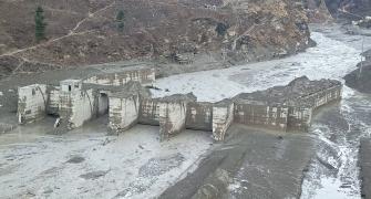
When a glacier falls causing massive flood and destruction, how does it happen and what changes does it leave in its wake?
Two things happened according to our present understanding.
First, a chunk of glacier fell down in the valley bottom at about 3,500 metres.
The satellite images show deposited sediments which we feel were actually stopping the glacial stream, and possibly absorbing the water from the glacier for quite some time.
This deposit happened after 2017. The possibility is that some portion of the hanging glacier portion fell down in this marshy area at around 3,500 metres.
Even at this height it can be frozen at the top, and exist in semi liquid form at the bottom.
When it was hit by this big ice chunk, the water locked inside this debris was released together with this ice and snow avalanche.
So this is our present understanding, but, of course, we need more time and more satellite images. Scientists will go there and study the local topography to confirm the sequence of events yesterday (February 7).
How fragile is the entire Nanda Devi ecosystem and how will it impact us in time to come? How can such disasters that are waiting to happen be prevented?
The whole Himalayan ecosystem is very fragile.
The Garhwal mountain range is perhaps the most fragile ecosystem because the local topography is specific to sedimentary rocks which are more fragile.
Himachal Pradesh and Kashmir have metamorphic rocks that are more resistant and have a strong composition. This is the reason why there are more frequent landslides in the Garhwal Himalayas compared to other parts.
Coming to your other point if there are disasters waiting to happen -- yes, I think that is very much possible because we have many glacial lakes.
An example we have already faced was the Kedarnath disaster in 2013.
There are many other lakes in the Himalayas which may burst because of increased water which is mostly due to enhanced glacial melting and also the increased temperature of the lake water.
The water level of these lakes is increasing and beyond a specific threshold these lakes may burst and release all the water and sediment along the way downstream causing devastation.

What can be done prevent glacial lakes from breaching their threshold?
There can be an early warning system against glacial lake outburst and floods.
For that, we need both field and satellite data to analyse the strength of the moraine which holds the lake.
We need to apply modeling tools for the future to analyse the water capacity of a lake which increases because of glacier, snow or rain.
This way we will be able to gauge how much water a fragile lake can hold. If there are chances of an increase in the water level, some water can be pumped out of the lake.
This is one of the methods which has been applied in Peru and Nepal.
We need similar initiatives and an early warning system in India.
Landslides and ice avalanches are happening more frequently because of global warming. We have to study climate patterns to find out those specific areas where there is probability of such occurrences in the future.
A lot of work has to be done in this direction in order to predict such disasters beforehand.
Is climate change one of the main reasons for the Chamoli disaster?
We cannot really say right now how this is linked to climate change, but one way or another it is linked with climate change.
Such events can also happen without climate change because snowfall is a natural phenomenon and over a period of time, the mountain slope is unable to hold more snow. That is what leads to an snow avalanche or an ice avalanche. That is how the excess snow and ice from a particular area is released.
Climate change has resulted in the slopes becoming more lubricated because of warm snow. The snow is close to zero degrees centigrade.
This makes the snow wet and we know that wet snow has a greater tendency for avalanche compared to very dry snow.
Overall, it is true that even without climate change, we will have such events, but climate change is the reason we are witnessing these events at higher frequency.
There are also a large number of hydro projects in the region. How do such projects impact the occurrence of such disasters?
That is a tricky question because hydro power is developed to control carbon emission. India is one of the countries where maximum energy is coming from burning coal. We install hydropower to control carbon emissions, but at the same time when hydro projects are under construction, there is a lot of local black carbon and dust released in the atmosphere which adds to global warming.
In my opinion, we cannot link it to such disasters because in the long term hydro power projects are beneficial because they cut black carbon emission.
But whenever we are constructing hydropower projects, we have to be extremely careful that these are far below fragile glaciers and steep slopes.
We should not construct our dams, and hydropower projects or any other construction very close to these ecosystems.
We need to investigate the local geology and the ecosystems very carefully before we start any construction,
Just as the glaciers are old, we have villages that have existed in those areas for many, many, years too. Earlier, possibly such disasters were not happening at this scale because the climate was not as warm like it is now.
But now with climate change, we may also need to shift villages that lie very close to such glaciers to mitigate the effects of any disaster.

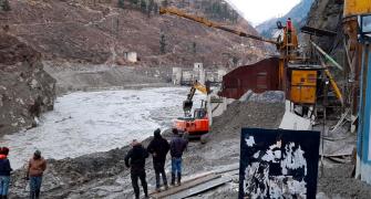
What are the after effects of such disasters? What are the things that they leave behind that we have to be careful about?
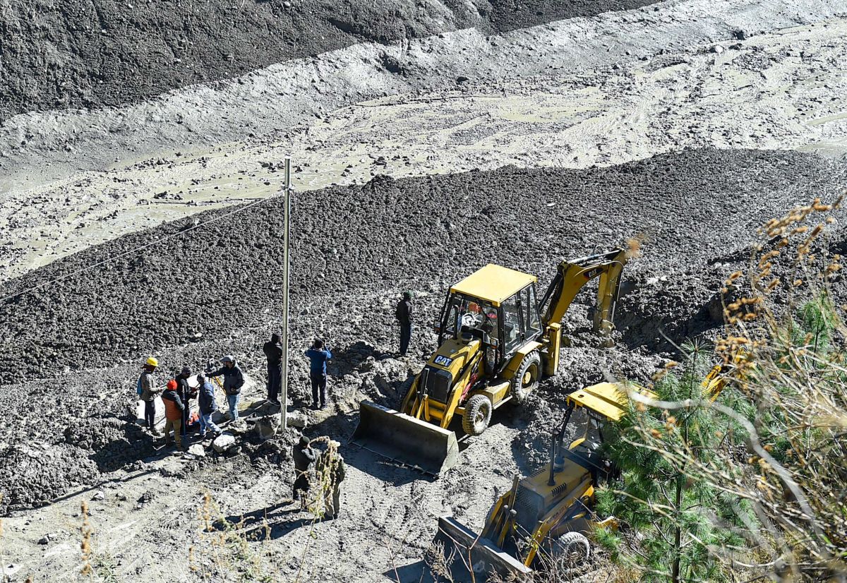
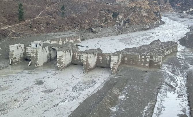
The sediment, rocks, water has been washed downstream. The workers are trapped inside the tunnel where they were working because the tunnel has been covered by silt. These are the post disaster effects.
I think we are working on those issues. This disaster is at a smaller scale compared to the Kedarnath disaster where the volume of water was very high.
The problem happened because the water volume was flowing through a very narrow gorge, just above Reni village.
The slope is extremely high and the valley is very narrow -- this is the reason it shot like a jet and the flow speed was very high.
Feature Presentation: Aslam Hunani/Rediff.com