'It could rain about 200 mm in short span of time.'

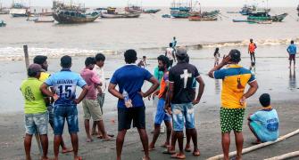
"Starting from the entire Konkan coast -- Ratnagiri, Sindhudurg, Alibaug -- going further north towards Mumbai, suburbs of Mumbai, be it Navi Mumbai, Panvel, Thane, Kalyan and going up to Dahanu and Palghar (will be affected by Nisarga," Air Vice Marshal G P Sharma, President, Meteorology and Climate Change, Skymet Weather Services, tells Prasanna D Zore/Rediff.com.
AVM Sharma, an alumnus of the College of Defence Management in Hyderabad, served in the Indian Air Force and retired as an air vice marshal.
Where is cyclone Nisarga right now?
It is still in the sea.
It is almost about 170 to 180 kilometres southwest of Alibaug and another 220-odd kilometres from Mumbai, again directionally southwest only.
Where is the landfall likely to happen?
It appears it should be close to Alibaug, plus-minus about 20 kilometres from Alibaug.
One must understand the landfall is not one moment; it will take some time.
My assessment is anytime after one o'clock we can have the landfall.
Which parts of the western coast will be affected the most?
Starting from the entire Konkan coast -- Ratnagiri, Sindhudurg, Alibaug -- going further north towards Mumbai, suburbs of Mumbai, be it Navi Mumbai, Panvel, Thane, Kalyan and going up to Dahanu and Palghar.
It could rain about 200 mm in short span of time.
As it moves further away from the centre of the sea, the intensity will be little less, but it will still be there.
It could then roll over into the Navsari area of Gujarat also.
Which parts of Maharashtra and Gujarat will be severely affected?
The Konkan region will be severely afffected as it moves fast.
Then it will go over to central Maharashtra, mainly the northern parts of central Maharashtra like Nashik, Ahmednagar, Jalgaon, Dhule, Nandurbar.
How intense will it be when Nisarga hits land?
What appears right now is that Nisarga should be a cyclonic storm and all cyclonic storms have a tendency to weaken a little.
To me it appears, based on the features I see, it should be a cyclonic storm and while crossing (from sea to land) also it will be a cyclonic storm.
During storms, wind speeds are anywhere from 60 to 80 kilometres per hour, but I will put it little on the upper side between 90 to 100 kilometre per hour.
The thing is where it will be striking (the entire Konkan coast), the terrain is very uneven; there are ghats, there are mountains; so it is not a levelled terrain.
Levelled terrains are very different because the gustiness of winds become more.
So wind speeds can vary up to 20-30-40 kilometre per hour and may also increase in intensity, while average wind speeds will be about 90 kilometres per hour.
What are the precautions people living in these area must take apart from being evacuated?
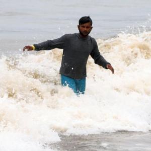
That is the only precaution: you need to be evacuated particularly from the structures which are weak, kutcha or thatched because these structures could be swept away by the winds along with heavy rains and this combination has maximum damage potential.
Along with that there is the high tide (around 10 am), and if there is a strong surge, and if heavy rains start, the rain waters won't go into the sea.
Fortunately, the (high) tide is around 10 o'clock only and by the time the storm strikes it will be receding, it will be going towards the low tide.
So, it may not aggravate the problem but there is a high tide around that time only with waves of around five to six feet high.
On top of that storm surge is going to be there.
People should obviously stay inside only, because it is going to disrupt the communications connectivity, even rail and road traffic will be disrupted.
People should not venture outside. Now (around 8 am) it's just about raining right light.
If you venture out and try to come back in the evening, you will find it difficult; better to stay indoors, at least today.
What are the chances that it could weaken by the time it has landfall?
I told you that all the storms, not only this (Nisarga), with their proximity to land become weaker.
It is intense when it is in deep sea, but when it approaches land, because of the intrusion of the land-air, it has a tendency to weaken a little.
And here the thing is, it's a difficult terrain also (that could weaken cyclone Nisarga further).
Even if it were to be a severe cyclonic storm, at the time of crossing it will become a cyclonic storm and the upper range of winds will be between 80 to 90 kilometres per hour.
Gusts should be more, but normal should be this much (between 80 to 90 kilometres per hour).
Is this cyclonic storm the onset of the monsoon?
These cyclonic systems are the drivers of the monsoon.
Cyclone Amphan brought monsoon to the south Andaman Sea; this system (cyclone Nisarga) brought monsoon to Kerala.
If you give me a chance, I will say this is the monsoon.
To me, it appears the monsoon. How else does the monsoon come?
Is this cyclone related to climate change, global warming?
It is climate change.
Basically, what climate change means is warming; more the warming, more is the frequency and intensity of the storm.
The heat potential is what feeds such storms.
Even if the sea temperature is more by 0.5 per cent even or one degree then it makes a phenomenal difference.
It will increase the frequency and intensity in the Arabian Sea, Bay of Bengal, and that is what the climate change is doing and it will continue to do.