 | « Back to article | Print this article |
Before undertaking such difficult projects as a 378 km railway line to Tawang, the government must seriously examine whether having quality roads is a better option, says Sanjeev Nayyar.
Even before the Dalai Lama's recent visit, and in response to the excellent infrastructure constructed by the Chinese in Tibet, there have been reports of India proposing to construct a railway line to Tawang in Arunachal Pradesh.
According to one such report, the 378-km railway line, with an elevation of 3,048 metres, would begin from Missamari near Tezpur in Assam and would, in most places, follow the existing 320-km Tezpur-Bhalukpong-Bomdila road.
Given the jingoism that surrounds such infrastructure projects, there was hype of India catching up with China, with a minimal understanding of the ground realities.
Anyone who has travelled to Tawang would know what a Herculean task it is.
The drive from Tezpur to Tawang is 320 km long via Bhalukpong, Seesa, Bomdila, Dirang, the Sela Pass and Tawang.
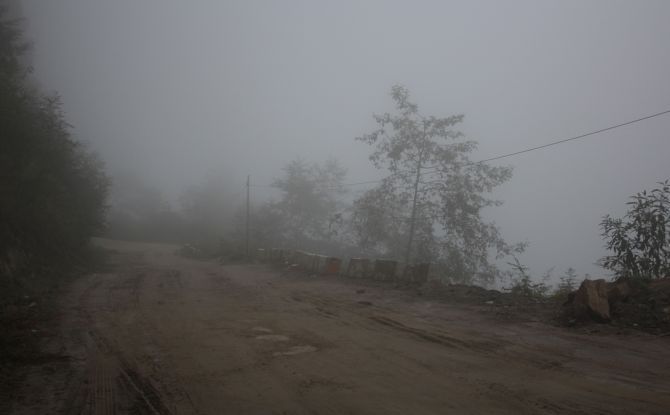
Yours truly drove from Tezpur to Tawang in September 2013.
The road from Tezpur to Bomdila passes through dense forests.
In most parts, the road is single lane. We moved from a height of 700 feet at Bhalukpong to 6,000 feet at the Nechiphu Pass, down to 4,000 feet at Tenga Rupa Valley and up again to 8,500 at Bomdila.
In spite of being only four people in a Tata Sumo, the drive was tough and exhausting. Moreover, we were lucky there was no rain or landslide that morning.
En route, we were shown a hill where, years ago, a helicopter crash took the lives of some Art of Living devotees -- a sobering thought as we drove up.
The drive from Bomdila to the Dirang Valley, a drop of about 3,500 feet, was really tough. It was very foggy both ways, and one could barely see ahead up to a few metres.
It did not matter whether the road had a black cover or was dusty as long as there was a road.
The road from Dirang to the Sela Pass meant a gain of 8,700 feet. The road going up to the Sela Pass, the world's second highest motorable pass at 13,700 feet, was the toughest.
The road goes up a single giant mountain.
A stop at the Jaswant Garh War Memorial cheered us up and made the drive post the Sela Pass relatively easier.
My experience could give one a sense of the terrain and difficulties while driving to Tawang in September.
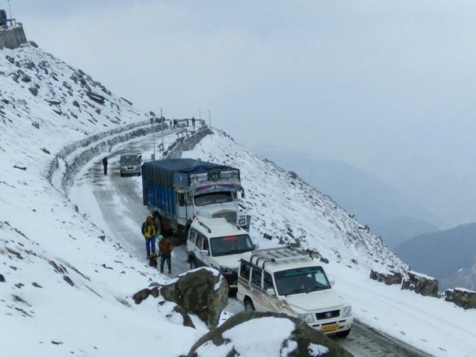
Vir Nakai of Helmet Stories, a company that organises Adventure Motorcycle Tours, says two months ago, they were unable to reach Tawang and had to turn back six km before the Sela Pass because of heavy snow and a blizzard.
Can the Indian Railways construct and maintain a 300+ km line in such terrain and weather?
By all means, one must think big. But before starting work on such an ambitious project, it might be useful to know the fate of the rail project from Jammu to Kashmir.
According to a July 2016 report on the Kashmir rail project, 'Metroman' Dr E Sreedharan said '12 years after the project sanction in 1994, work on the 124-kilometre Katra to Banihal section has been lingering. Progress on this section is not even 20 per cent. With the present style and speed of construction, it would take another 10 years for completion with severe cost escalations.'
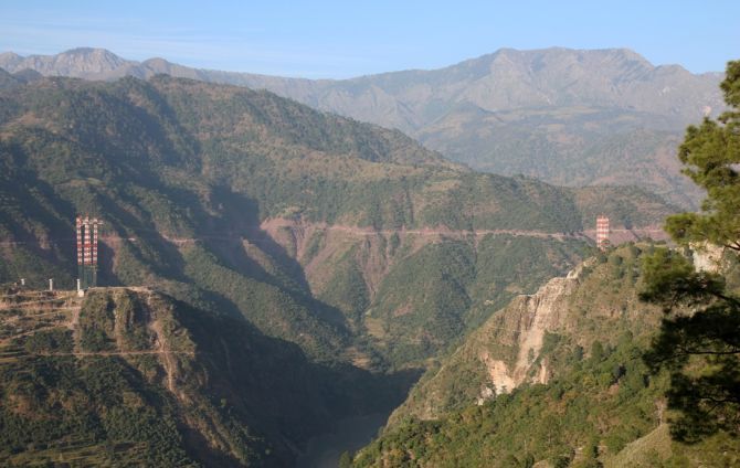
Dr Sreedharan had also pitched for a safety review of the proposed Chenab bridge -- touted as the world's tallest rail bridge -- that is being constructed on the route.
In October 2014, I visited Reasi, where the bridge is being constructed, about a four hour drive from Jammu.
Though the work is in progress and thousands of crores of rupees have been spent, the completion date is still uncertain.
According to a media report of May 4, the bridge will be completed in two years' time, but it does not say when the railway line from Katra to Banihal will be operational.
Before undertaking such difficult projects, the government must seriously examine whether having quality roads is a better option.
The recently inaugurated Chenani-Nashri tunnel that links Kashmir with Jammu by an all-weather route, and built at a cost of Rs 2,500 crore (Rs 25 billion), is a good example.
Alternatively, if railway connectivity is needed, it must be along the same alignment as the road being planned; which means having good roads in such cases as Tawang is a precursor to rail connectivity.
Sounds like a good plan, but what is the condition of the roads today?
According to H V Kumar, who runs a very popular road travel blog and who visited Arunachal Pradesh in 2016, the condition of the road to Tawang has improved since 2013, even though there is scope for huge improvement. Roads are being widened and most of them are tarred.
However, sources in Tawang say the Border Roads Organisation is lagging far behind in the improvement of the Balipar-Charduar-Tawang road.
Kicked off during the United Progressive Alliance regime, only about 40 per cent work on the 317 km has been completed.
Worse, the stretches that have been completed are again calling for maintenance because of the poor quality work.
A January 2015 report quotes then BRO director general Lieutenant General R M Mittal as saying that the BCT road would be completed by 2016. We are in 2017 and the road is nowhere near complete.
Sources say a two-lane road from Orang-Kalaktang-Rupa-Tenga, which was started almost a year or two after BCT, was inaugurated in October 2016.
To be fair to the BRO, the OKRT road is 158 km long as compared to the BCT's 317 km. But that there is a delay in completing the work is beyond doubt.
The good thing is one can use the OKRT road to reach Tawang via Tenga (Shergaon) or Bomdila.
The OKRT, Kumar says, is not as popular as the BCT. Mostly because of the powerful Tezpur-Tawang taxi lobby which prefers the BCT. But the OKRT route is more popular with some taxi operators directly operating from Guwahati.
At a more macro level, Lieutenant General Prakash Katoch (retd) struck a discordant note in a recent article: 'The Parliamentary Committee for Defence has been rapping the government for its lackadaisical approach to defence, however, this time it is the Comptroller and Auditor General who has pulled up the Border Roads Organisation for inordinate delays in building strategic roads facing China.'
'It has pointed out several deficiencies like faulty construction, defective alignment and improper contract management; not that the CAG doesn't not bring out such anomalies from time to time against government organisations including the army, navy, air force,' General Katoch added.
On Army Day (January 15) this year, army chief General Bipin Rawat stated that of the 72 strategic roads, only 22 have been completed after so many years, and 'all of the 14 strategic rail lines approved remain on paper only.'
Why does the BRO not give out border road contracts to large infrastructure companies?
Let there be a healthy competition between service providers. Higher cost could get compensated with timely completion, better quality of work and penalties for delays.
Lack of adequate infrastructure demoralises the border population and makes them vulnerable to external influences.
Improvement of border infrastructure must get priority under the prime minister's 'Sab ka saath, Sab ka vikaas' goal.
Instead of announcing huge border projects and letting them remain on paper or incomplete, the government must undertake a few mission critical projects and complete them.
The construction of a quality, all-weather road to Tawang must become a national priority.
Sanjeev Nayyar, an independent columnist, tweets @sanjeev192
MORE FEATURES in the RELATED LINKS BELOW...