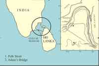
The Rs 2,427.40-crore Sethusamudram canal project aims to create a navigable channel of 152.2 km from the Gulf of Mannar to the Bay of Bengal through the Palk Bay and Palk Strait.
The project that was inaugurated by Prime Minister Manmohan Singh on the July 2, 2005, has drawn flak from many quarters from the day the idea was mooted.
One of the debates going on is whether the chain of islets called Ramar Sethu, also known as Adam's Bridge, linking India with Sri Lanka should be destroyed while dredging.
Dr S Kalayanaraman, eminent research scholar who has earlier done signal work in locating the mythical river Saraswathi, has been associated with the move to prevent the dredging of Ramar Sethu.
He has been researching Indian civilisation and Indian languages for quite some time, and is a former employee of the Asian Development Bank.
 He says the project should not progress as it is and argues his point citing archaeological, scientific, textual and cartographic evidence to show that Adam's Bridge is actually Ramar Sethu and it is several centuries old. He says it is indeed a world heritage site and should be declared as one at the earliest.
Before we get to the existence and ancient nature of Ramar Sethu, let us first look back when the first idea for a canal in the Gulf of Mannar originated. It was first conceived by a British commander of the Indian Marine A D Taylor in 1860, but was discarded because it did not make economic sense.
In 1956, the Sir A Ramaswamy Mudaliar Committee, constituted to develop the Tuticorin port, came out with a report that discussed reducing the maritime route around the Indian peninsula by avoiding circumnavigation of the island of Sri Lanka. It spoke of nine alignments and all of them were land based canals.
The report said the advantage of a land based canal was that it can be adequately deep and still keep the canal safe by having locks on either side where it met the sea. The land based canal would avoid dredging in the serene Gulf of Mannar and keep it safe from the turbulence of the Indian Ocean.
According to Kalyanaraman, the report also clearly stated that any idea of cutting a channel through Ramar Sethu should be abandoned because of the problems of maintaining a mid-ocean channel and the "turbulence of the Indian ocean waters."
After criticism arose about the Sethusamudram Canal project, the Minister of Tourism and Culture Ambika Soni said in a written reply in the Rajya Sabha that there were no archaeological studies that revealed the existence of a bridge called Ramar Sethu between India and Sri Lanka.
Kalyanaraman lists cartography, textual, and epigraphic evidences to show that a bridge called Ramar Sethu existed.
 "A NASA satellite picture has shown the existence of a stretch of land bridge in the Palk Strait between the countries," says Kalyanaraman.
He cites two items from the NASA website.
February 2000 report of NASA: Shuttle Radar Topography Mission of NASA aboard the space shuttle Endeavour launched in February 2000. It says, "Sri Lanka is shaped like a giant teardrop falling from the southern tip of the vast Indian subcontinent. It is separated from India by the 50 km-wide Palk Strait, although there is a series of stepping-stone coral islets known as Adam's Bridge that almost form a land bridge between the two countries."
The second item is a photograph taken by the Gemini mission of the 1960s that shows the clearly visible outline of the "bridge."
But what Kalyanaraman wants to clarify is that the Sethu, or bridge, is centuries old. "Sethu in Tamil means "manmade bund" and this bund is called Sethuband. Asiatic Society, 1799, refers to the bridge that is broken at three places. It also says "people call it a bridge; or otherwise it appears to have wood growing on it, and to be inhabited."
"The Sethupatis of Ramanathapuram are called so because they were expected to protect the Sethu."
He further adds two other evidences, "The Madras Presidency Administration Report 1903 refers to the bridge as a glossary entry: 'Adam's Bridge is called the bridge of Rama. It really joined Ceylon to India until 1480, when a breach was made through rocks during a storm. A subsequent storm enlarged this and foot traffic then ceased.'
"The next is a book written by Alexander Hamilton in 1744, A New Account of the East Indies which describes his visit to 'Zeloan' by walking on the bridge."
"In the Aganaanooru Sangam literature text also, there is a reference to Sethu and there are hundreds of references to Rama," Kalyanaraman added.
All these were put together by Schwartzberg and the University of Chicago as Schwartzberg Atlas that have around 100 maps showing Sethu (in bracket, it is written Adam's Bridge) clearly and the maps are dated back to the seventh and the twelfth centuries.
In 1788, Joseph Parks, a Botanical explorer from Australia marks the structure as Rama's Bridge. But it is renamed as Adam's Bridge in the 1804 Survey of India map.
Kalyanaraman also speaks about thousands of copper, gold and silver coins with the word Sethu on them that have been recovered in Jaffna. They were issued circa the twelfth to fifteenth century.
Paranthaka Chola of the tenth century copper plates and the copper plates indicate that Aparajitavarman went to Sethutirtha.
"Krishnadevaraya's epigraph mentions that his territory extended from Sethu to Vijayanagaram."
Another important reason cited by Kalyanaraman why a canal should not be built in the region is because Sankha or Turbinella pyrum is found in the region and not found anywhere else in the world.
 "In a place called Keezhakarai, a surviving industry which is 8500 years old is that of sankha. Divers go into the shallow depths of water and pick up sankha. No Bengali or Oriya marriage is complete without the Sankha bangle. The heritage of this place is linked to the Saraswathi civilisation."
When the Survey of India was first set up in 1767, the logo said "From Sethu to Himalayas."
"So, Sethu was looked upon as a boundary of India even then," said Kalyanaraman.
Kalyanaraman asks, "Do you want to be like the Taliban who destroyed the Buddha statues in Bamiyan by calling it mere pieces of stone? Section 295 of the Indian Penal Code says sentiments of the people about sacredness should be respected. If anybody hurts the sentiments of people, it is a cognisable offence. But here, the state says a monument does not exist and is trying to destroy it instead of protecting it. With all these evidences to back my point, I say that Ramar Sethu should be declared a world heritage site."