|
|
|
|
|
| HOME | NEWS | INTERVIEW | |||
|
September 5, 2001
NEWSLINKS
|
The Rediff Interview/ V K Gaur
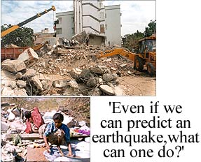
Red rain in Kerala. Red wells opening up in parts of the Deccan plateau. Tremors in Bangalore. Another earthquake in India, this time South of the Vindhyas? These are some of the questions irking both administrators and citizens alike. And in an attempt to find answers, the Government of India has set up a high powered committee headed by internationally renowned seismologist V K Gaur. M D Riti spoke to Professor Gaur in Bangalore, who had just returned from the committee�s first strategy planning meeting at Kerala. Will your committee help predict the next earthquake in South India? Today, it's not possible to predict earthquakes. It is practically attainable, though, to put a maximum limit, with a high degree of probability, to the ground-shaking intensity of a region. Given that knowledge, we will have to spring into action and design our buildings in such a way that even if an earthquake takes place, the buildings are safe. Even if we could predict an earthquake and say when it will occur, what can one do other than ask people to come out of their houses or workspots? And after the earthquake has passed, it will have left all those people destitute. What does not seem to trouble our conscience at the moment is the enormous amount of destitution caused by earthquakes. So many people are left back alive, but without the wherewithal to live. The important question we should ask, therefore, is: can we, with a very high degree of reliability, work out what are the levels of ground-shaking at which places, over the next 50 or 100 years? Then, we should take measures that are essentially of an engineering nature to do the following things: one, classify the land. Some kinds of land begin to shake rather violently because of loose soil. Other lands maybe rocky or have consolidated soil, and will be less liable to shake so violently. Land use planning would help mitigate the disaster caused by quakes. Second, draw up a code for building and construction plans and designs. According to this, the ground-shaking potential of an area that is to be built upon must be taken into consideration. This is something I am sure engineers never took into account until now. Third, we should look at all the big public buildings already in existence, in which large human activity takes place. Schools, colleges and hospitals, for example, must all be assessed. Power generating houses, transport systems, and other utilities, must also be studied. Then, we should ask engineers to go around and determine whether these are safe for the level of ground-shaking that can be expected in those spots. If they are safe, no questions need be answered. If they are not, then we must also have engineering designs to retrofit them. Remedial measures must be taken to ensure that they will not become death traps in the future. Engineering solutions can certainly be found to all these issues. What exactly will your newly constituted committee on earthquake zone mapping and management do then? To start with, we were trying to figure out how many seismic recording stations we need to have in this area. We will also look at small tremors that we have been having and locate them. When we actually plot their locations, we may find that they are scattered over a large area. But if we locate them very carefully, we will probably find them all on a single line. We have identified the minimum number of stations required to do this kind of mapping. However, the bigger earthquakes cannot always be felt in advance. We have decided to study everything below 18 degrees latitude in India, which basically comes down to some parts of Andhra Pradesh and the whole of Karnataka, Tamil Nadu and Kerala. Can you outline briefly what we can do to mitigate, manage or prevent the disaster that earthquakes seem to cause? To put it very briefly, we can classify land for land use planning, design buildings that will withstand earthquakes, identify the vulnerability of existing buildings, and make designs to retrofit those buildings to make them safe. We could also make sure that our network of roads is so made that they do not add to the trouble following a quake. Do away with narrow lanes, for example, which will result in people spilling out of their homes and possibly being killed by bricks falling from on top of buildings. What we should do, meanwhile, is to put a large spread of engineers to study the public buildings and give us some notional ideas of what to do in the immediate future. They could study, for example, which buildings were affected in recent tremors, and form some kind of a map that would show us weak zones in these states. We can quickly look at buildings that are manifestly vulnerable, and do something about them. We can also distribute pamphlets to people, to tell them to ascertain whether their houses are built in a certain way to help them withstand a quake, or not. Communication systems should be improved so that people know where to go in times of a natural disaster. Now they all tend to congregate in one place and jam up that place. If we have land use planning maps made, we would also know, after a quake, which spots would have suffered the most, even without actually going and seeing there. The relief and rescue headquarters could have a map, to start with, of where the damage would be most. You can direct rescue operations in a better informed and planned manner. How do you determine the intensity of ground-shaking in an area? If one knows where the weak spots in a zone are, one can predict where tremors will be felt the most. It's something like this: if one has a table that is subject to high pressure at certain spots, one knows where the table is going to crack. It will crack along the weak grains that exist in it. Before it actually cracks, there will be some movement along those places. Today, there are at least three methods by which you can determine ground-shaking intensity. The first is by using global positioning systems, through which we can see ground movements. There is a possibility of seeing where energy is being accumulated, and finding out where cracks might occur. The second is by just looking at scars on the earth surface. Like an injury on your body, the grainy surface of the body is slightly different. The third is by having a number of seismic stations that record ground vibrations. Even before a reasonably well-felt earthquake takes place, you will have tiny squeaks occurring. And this will happen along those places where there are weaknesses. If you can locate and map them, you will know where they are. There is a need to mount all these methods so that you get a knowledge-based database of information. This approach along with others, like retro-fitting existing buildings to withstand quakes better, classifying ground as compact or loose soil and building accordingly on them, will help us to tackle earthquakes better when they occur. What about the red wells that have opened up recently? The Kerala region is very old. If you had been alive, say, about 25 million years ago, you would have seen that it was an arid place. Now, with rainfall, wind action and pelting with little bullets of sand, all natural processes of erosion year after year, soluble materials on the earth�s surface there have dissolved. What has been left behind is that which is not soluble. The first thing that is left behind on the top is iron oxide, better known as laterite. After millions of years, as soluble materials percolate downwards. They are held fast at places along the way as they travel downwards. If you imagine this process recurring over thousands of years, the crust left behind will have a lot of laterite and therefore the soil is red in colour. What you have, in effect, is a laterite top, with some accumulation of these soluble materials which will have some kind of base of calcium, aluminium and magnesium, which is what gets easily dissolved in water. If this amount is large and somehow the aluminium can be precipitated, then underneath the laterite you will get a rich aluminium layer. It will be mixed with some very fine material called clay. I can only speculate on what has happened in these regions where the wells have opened up, but I think my speculation maybe quite accurate. There must have been a topsoil of laterite. Below it, there is soluble material that has gone down and formed clay. If you go deeper and deeper, you will find other materials. Imagine this situation. You have a lot of cars coming in from one side, down a particular road. They come up against an obstacle that slows them down considerably. They will bank up. This is exactly what I think must have happened there. Rainwater would have flowed easily down through the laterite layers until it encountered the clay layer, where it would have got blocked. This accumulation of water over the years would have created a great pressure, weakened those walls. Wherever there is a hole in that pressured area, pressure will increase around it and eventually that spot will collapse. Elsewhere you may have a weak zone because the laterite may have been washed away or broken. There is so much human activity that can also cause this. People use laterite for bricks. If the clay layer is exposed, the clay layer itself may crumble and cave in. It may look like a well. This is all pure speculation. To be sure that this is exactly what happened, somebody must give us exact data. This question was also asked in the committee that I head to study earthquake management. I told them that there was nothing much we could make out because all the evidence we had been given so far was purely anecdotal. If we had even a clear soil profile, we could have come up with some conclusions. We could have put some numbers on it if we had had a good sample of the soil. We could have put these numbers together and said how much pressure had built up. But this was not done. I think this was most irresponsible. There are so many competent people in Kerala. The government could have asked any of them to do this. This should be done before we draw any conclusions. Instead you have someone coming up with a bucket of soil saying that he collected it from a red well. You do not know what else was in that bucket before the soil went into it. How can you draw any scientific conclusions? You can only speculate. Are the recent occurrences of red rain in Kerala symptomatic of an earthquake that will soon hit that area? No, they do not seem to be related to the occurrence of earthquakes at all. Of course, many things in life happen to take place simultaneously, even though they are not connected in any way. One should not simply link them unless one has a logical reason to see the cause and effect. Otherwise, it will just be as if we are practising astrology, making unreasonable predictions! The one thing that I can certainly say is that this was no supernatural phenomenon. I suspect that if there was a lot of red rain, it maybe laterite topsoil that came down as dust with the rain. Once the new seismic recording stations are in place, will you be able to start mapping the area quickly? People think if you put in a couple of seismic instruments, you will know when the next earthquake is coming. But what are those seismic instruments going to do? If they are properly located and are appropriate for their use, then they might be useful. I am sorry to say that there is a lot of money available in this country for buying scientific equipment, and a lot of agents roaming around trying to sell equipment of dubious quality. As I said before, if you have the right equipment and know-how, we should be able to come out with a map of earthquake prone zones in five years. But even before you come out with such a map, you can use whatever other knowledge you have, like satellite imagery, to form some idea about soil erosion and vulnerable areas.
ALSO READ:
Tell us what you think of this interview Design:Dominic Xavier |
|
HOME |NEWS |
CRICKET |
MONEY |
SPORTS |
MOVIES |
CHAT |
BROADBAND |
TRAVEL ASTROLOGY | NEWSLINKS | BOOK SHOP | MUSIC SHOP | GIFT SHOP | HOTEL BOOKINGS AIR/RAIL | WEDDING | ROMANCE | WEATHER | WOMEN | E-CARDS | SEARCH HOMEPAGES | FREE MESSENGER | FREE EMAIL | CONTESTS | FEEDBACK |
|