Information Technology Minister Pramod Mahajan says REDAKE (short for 'Republic Day Killer Earthquake') measured 6.9 on the Richter Scale. "We will stand by this figure," he said, amid conflicting reports about the magnitude of the disaster.
Dr Harsh Gupta, director of the Hyderabad-based National Geophysical Research Institute, told rediff.com the quake-measuring instruments in his laboratory stopped functioning because the intensity of the tremors was over 7.0, the upper limit of the instruments. "It must be higher than 7.0," he said.
Elsewhere, the US-based Incorporated Research Institutions for Seismology or IRIS, considered a reliable source of accurate quake information, said it measured 7.9, just a decimal point less than what is the considered the gravest magnitude.
Confusion ensued. For the lay people, it seemed so much jargon and mumbo-jumbo. In order to make matters clearer, Y Siva Sankar compiled this ready-reckoner on earthquakes:
What is an earthquake?
The surface that we walk on appears hard, almost rock-solid. But Earth's surface is, in fact, not a stationary layer of soil. It is made up slowly-moving sections. In other words, they are dynamic. These sections are called tectonic plates.
 Tectonic plates are, thankfully, lazy and could give snails a complex. As a result, their movement can be detected only on geological time-scales. If you trawl the Internet a bit and research, you will discover that North America and Europe -- to give tectonic plates names of continents -- are drifting apart at the rate of five centimetres per year.
This ultra-slow motion, nevertheless, builds up enormous stress in the crust. If stress levels soar beyond a certain threshold, a portion of the crust will implode, moving suddenly, and, often times, violently. This sudden movement occurs along a fracture called the fault zone, where the earth's crust is weak. And that, folks, is an earthquake. Click here for animations of earthquake funda.
Is there any way one can protect oneself during a quake?
Yes. The first thing is to have presence of mind. Do not panic. It never helps. This is easier said than
done. But then, who said lives can be saved easily? The moment you are conscious of the fact that you in the midst of a quake,
the best thing to do is to get into an open space as quickly as possible.
Or, if that is not possible, crouch under big tables: this might help protect themselves from the debris.
Another tip: do not get into the lift (elevator); climb down the staircase to the ground if you are in a
high-rise structure. If you are on the bed, you should roll off it or crouch in a foetal position. You should
move next to a solid object which is not likely to get crushed in the earthquake and can withstand any
fall.
Asked what he did at the time of the quake, one of rediff.com's senior staffers, who lives
in Borivli, a northwestern suburb, said: "My wife, my little daughter and I stood under the main
doorframe." So there.
Is it possible to create tremor-proof buildings?.
Japan and California have such buildings which are base-isolated. The foundation is isolated and has
steel springs so that none of the tremors pass through to the building.
But whether this will happen in India is a little difficult to forecast at this stage. However, a
rediff.com staffer who lives in Mira Road, another northwestern suburb, claims newly
built buildings in his locality are quake-proof, thanks to the same technology employed by builders.
Is it likely that the Republic Day earthquake may trigger some more quakes, even in other
areas?
Difficult question. If one says yes, it would sound alarmist. But then, latest reports indicate that
Ahmedabad and other places in Gujarat experienced tremors, with magnitude upwards of 5.5 on the
Richter Scale, on Sunday morning (January 28), two days after the main quake.
An earthquake in California did trigger off earthquakes 800 kilometres away. Experts says this
Gujarat-centric earthquake may not trigger off any more similar disasters in other places.
How are earthquakes measured?
The scale for measuring earthquakes was first developed by geologist Charles Richter at the California Institute of Technology in the 1930s. As was the Richter Scale, which is named after him.
However, the Richter Scale is only one of the several methods that seismologists use. But it has become famous because it gives an easily understandable number, called the magnitude, to an earthquake. The bigger the number, the more devastating the quake.
So a quake measuring 4.0 on the Richter Scale is okay, no great shakes (pun unintended). But a 6.0 is dangerous, and anything above 7.0 is, to put it simply, disastrous.
A seismograph is what indicates this magnitude. It keeps drawing a line on a paper, the line representing movement of the earth's crust. Its other end is inserted deep into the layers of the earth. In some ways, a seismograph looks like angiogram or any other medical graph you get to see on computer monitors used in the hospital scenes in movies.
Generally, it's a straight line. But if there's an earthquake, there are violent-looking deviations on the graph. There are no lower and upper limits on a Richter scale, only a "logarithmic" rhythm. Meaning: measurements are in multiples -- each higher point represents a 10-fold increase in the magnitude (read power) of the quake.
There is a discrepancy on the magnitude of the Gujarat earthquake -- the IMD says it measured 6.9 while according to the USGS it measured 7.9 on the Richter Scale. Why?
The updated USGS magnitude is 7.7. That helps, but does not
remove the discrepancy. The initial magnitude from the USGS was a
surface wave magnitude (7.9). The updated M7.7 is the Energy or
Moment magnitude, a more reliable measure, particularly for large
earthquakes.
Moment magnitude is now almost universally accepted as
the magnitude, though it is not available as rapidly as the surface
wave magnitude. Many independent analyses have confirmed a Moment
magnitude ranging from 7.6 to 7.7.
The details of the 6.9 Indian Meteorological Department magnitude are fuzzy. Maybe,
it was a locally determined magnitude, not a Moment magnitude.
Quite often, a locally-derived magnitude saturates, or fails to
recover the full size of the earthquake.
Is there any way by which an earthquake of such intensity can be
forecast?
The relative intensity of shaking can be partially understood by
knowing what soil/rock is in an area, and what faults might rupture
and with what magnitude. But it is not possible to know when such
earthquakes will happen.
Some tremors were felt before the killer earthquake. Can it be said that those tremors were a warning of things to come?
Many times people feel small earthquakes, but no large earthquakes
follow. This is a limitation with earthquake prediction. There are
many, many small earthquakes and nearly all of them are not followed
by larger ones. We have no way of knowing at this time which ones
will be followed by larger ones. We can only see that in hindsight.
In Los Angeles this past year, locals have felt many small earthquakes,
none of which resulted in a larger earthquake. If people assume that they
were warnings, they would be mistaken.
Is Kutch in Gujarat under threat of facing such a
quake again? There have been almost 500 aftershocks in the region already.
After a large earthquake there are always many aftershocks, and there
is always a chance of damaging ones.
In the past, have two earthquakes of almost the same magnitude hit
the same area in rapid succession?
This can and has certainly happened in the past, but it is the
exception, not the norm.
What happens inside the earth during a quake?
Good question. A tremendous amount of energy is released; the amount increases with the intensity of the quake. The rate at which the energy is released rises by a factor of 32 for each one-point increase in the magnitude of the quake.
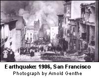 The "7+" earthquakes release so much energy that man-made explosions cannot even begin to match it. In 1906, San Francisco was rocked by a quake measuring 8.3; its power was enough to destroy one million Hiroshimas.
What is the least magnitude that a person can feel?
Anywhere between 2 and 3. Magnitude 5 is regarded as moderate and can be a cool, even memorable, experience for a large number of people. No major damages. But we'd like to point out that our world suffers 1,500 quakes of magnitude 5 or higher every year.
If the Richter scale touches 6, it is big. Bad. The worst quake in human history measured 9 on the Richter Scale.
Are some places more prone to earthquakes than others?
Yes. As we said earlier, when two tectonic plates kiss, sparks fly, fires rage (volcanoes) and the earth shakes, leaving behind a trail of death and destruction. Call it The Deadliest Kiss, if you will.
On the surface, stretching over thousands of kilometres, people may be blissfully unaware that, beneath their feet, two huge blocks of earth (tectonic plates, dummy) are inching towards each other. And, somewhere on the surface, unmarked, are the boundaries of these places. The people/places located on these boundaries face the maximum risk at the time of The Deadliest Kiss.
Well-known tectonic boundaries on Planet Earth are the edges of the Pacific plate, which lies beneath the Pacific Ocean. This plate is relatively hyperactive, which explains the frequent earthquakes along the west-coast of North America and in Alaska, Chile and Japan. It is also known to cause volcanic eruptions in north-west US, the Andes Mountains and the Philippines.
Which are the major earthquake-prone areas in India?
The entire northern belt in India is earthquake-prone. From Assam right upto Kashmir to the Narmada
Sohn Linearment to the Koyna belt which sees a slot of seismic activity.
So earthquakes occur only on the boundaries of tectonic plates. Right?
Wrong. Rather, partly right. Not all quakes occur at plate boundaries.
Research on the Internet reveals an interesting piece of information. In 1811-12, powerful quakes measuring 8.4 to 8.7 rocked the sparsely populated Mississippi valley in the US. Tremors were felt in Boston and Denver, hundreds of kilometres away. However, the quake proved relatively harmless: there was little damage and few casualties. Boston and Denver, in this case, were far away from the plates's boundaries. Geologists refer to these safe areas as "stable continental regions" or SCRs. When tremors rock these safe areas, it is called an SCR earthquake.
I think I asked this before. Anyway, can't earthquakes be forecast?
No. Earthquakes cannot be forecast. Period.
However, scientists have developed ways of making meaningful guesses.
Guesses?
That's right. Guesses. A statistical study of the history of earthquakes in a given region yields information like the frequency of quakes, change in magnitude over the years and so on.
Let's say, for example, that Bombay had quakes of 6.0 in 1950, 5.6 in 1960, 4.8 in 1970, 3.2 in 1980, 6.6 in 1990 and 7.2 in 2000. This is just an example, mind you. So you have a rough idea of the pattern in quakes: down, down, down, bottom, sharply up, further up.
If a certain region experiences eight quakes measuring 5 on the Richter Scale in the last 150 years, seismologists would say there might be a quake in the next 30 to 40 years. They can measure the stress level and its rate of increase in the earth's crust in a certain region. Coupled with knowledge of the time that has elapsed since the last earthquake, scientists can hazard a guess about whether another earthquake is likely in the region.
This method is imperfect, yes. It needs meticulous examination of seismological data. However, there is no such data about most regions.
What is the epicentre of an earthquake?
Unlike the equator, the Tropic of Cancer, latitudes and longitudes -- all of which are imaginary -- the epicentre of an earthquake is real. It is the point on the surface of the earth that is vertically above a quake's point of origin and is denoted by its latitude and longitude.
What is the origin of an earthquake?
 The origin of an earthquake is called the Hypocentre. It is also called the Focus. It is the point within the earth from where seismic waves originate. The vertical distance between the hypocentre and epicentre is called Focal Depth.
How is the epicentre determined? I mean, how did the experts determine that Bhuj was the epicentre of yesterday's quake?
Good question. We could answer that, it would be easier for you to click the following hyperlink to epicentre funda.
So many terms!! OK, tell me again, what is magnitude?
Sure. Magnitude is the measurement of the size of an earthquake expressed in terms of a numeral. Magnitude represents the energy of an earthquake.
Here's a quick method to classify earthquakes on the Richter Scale:
- Less than 3.5 = Generally not felt, but recorded.
- from 3.6 to 4.5 = Often felt, but rarely causes damage.
- From 4.6 to 4.9 = Slight damage possible.
- From 5.0 to 6.9 = Moderate damage, but buildings designed to resist earthquakes could escape with slight damage. However, it can cause major damage to poorly constructed buildings.
- From 7.0 to 7.9 = The damage resulting from these kind of quakes can be devastating (Bhuj, January 26, 2001).
- From 8.0 to infinity = Deadly!
Would you explain what a Richter Scale is once again?
 Remember that line about the scientist after whom the scale is named? An improved version of this scale was created by Japanese seismologist Hiroo Kanamori in 1977; it is called the Moment Scale.
Both scales are similar in that the stronger an earthquake, the higher its magnitude.
The magnitude is measured on the basis of the ground motion recorded by the instrument, after accounting for standard correction to discount the epicentral distance from the recording station. It is linearly related to the logarithm of the amount of energy released by an earthquake.
For your benefit, this is how the dictionary defines it:
Rich�ter Scale (rktr skl) n. = A logarithmic scale ranging from 1 to 10, used to express the total amount of energy released by an earthquake. In this scale, an increase of 1 represents a 32-fold increase in released energy. [After Charles Francis Richter (1900-1985), American seismologist.]
Thanks. But what is intensity? Yesterday, several reports on rediff.com and other websites mentioned intensity as well as magnitude. Are they interchangeable terms?
Intensity is one thing, magnitude is something else. You know, by now, what magnitude is, so we won't go into that. Intensity refers to the rating of the impact of a quake at a particular place. It is determined by studying the affected areas, using a descriptive instrument like the Modified Mercalli Scale.
How well-equipped is India to study earthquakes?
The Indian Meteorological Deparment has 45 national seismological observatories. There are nine observatories for special studies in north India and three mobile observatories in and around Delhi.
Ten observatories in peninsular India were upgraded in 1996-97. A National Seismological Database Centre and a Central Receiving Station have been established in New Delhi to receive, archive and analyse seismic data.
The NSDC gets both digital and analog data in real time. Well, almost. In 1999, 12 more seismological observatories were upgraded to analyse broadband digital seismographs. The NSDC is capable of quick event determination and dissemination of information in an operational mode. Its seismology division responds to queries relating to earthquakes. It also develops and manufactures seismological instruments and accessories in the IMD Instrumentation Workshop at New Delhi.
Do you think I need to know anything else about earthquakes?
That would depend on your curiosity. If you are the kind who is always hungry for more information, click on the following links. They will lead you to seemingly endless knowledge of earthquakes.
The RD Killer Quake of Jan 26, 2001: Technical details
Significant earthquakes in India and its neighbourhood
All about earthquakes in India and their impact
India Meteorological Department's earthquake reports
Disaster relief set-up in India
Major earthquakes across the world in recent times
Earthquake News: Comprehensive news, information and features
A post-quake volunteer's unusual tryst with the departed
Earthquake site map
USGS: Earthquake Hazards Program
Design: Lynette Menezes
Back to top
Do tell us what you think of this ready-reckoner on earthquakes